Trails and Tribulations
(Scroll down toward the bottom of the page for photos)
This was my first hike beyond Wy'East Camp on Eagle Creek Trail. As an adult, I've ventured on to the Eagle Creek Trail 3 times prior to this trip. The first time, I made it to Tenas Camp, made a fire, relaxed for a bit and hiked back out. The second time, I stopped at a campsite just beyond the 4 1/2 mile bridge, made a fire, relaxed for a bit and hiked back out. The third time, I hiked in to Wy'East Camp, set up a tent, stayed the night and hiked back out the next day. Aside from that, the only real "hiking" I've done is around 100mi/mo of in-town surface roads for the last several months. So, I'm just getting my "trail-feet" on, so-to-speak.
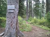
I arrived at the ECT trailhead (via my lovely girlfriend) at about 07:15 and, after some adjustments, I was making my way down the trail by 07:30. I set myself a fairly quick pace, since I've seen the first 5 miles enough times already, and was trucking right along. I stopped to make another adjustment a couple minutes later and was passed by a nice older guy and his beautiful beast of a dog (complete with "saddle bags"). Even with my quick pace I didn't see them again for quite some time.
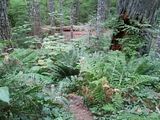
As well as this being the first time for me hiking this distance, this is also the first time I've done any of the ECT solo - and I've never set foot on the PCT. I expected the first 5 miles of the ECT to be boring but being on the trail by myself (aside from the friendly passersby) lent it an entirely new feeling. I noticed a lot more about my surroundings being by myself and I definitely spent a lot more time inside my own head amongst my thoughts. I stumbled upon the thought that, I'm not walking somewhere, I arrived somewhere to go walking. I wasn't on the trail to get to destinations, I was on the trail because it was my destination. Remembering that fact definitely helped any time the trail got tedious (which was rare, especially later!).
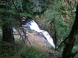
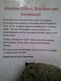
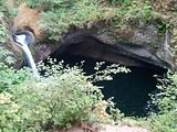
I arrived at the Punchbowl Falls overlook at 08:17, snapped the obligatory photo and kept on truckin'. Just down the trail a bit is a place where people have begun to carve a "trail" down to the ledge that sits over Punchbowl Falls. I went down the "trail" on my 2nd trip on the ECT and it does indeed reward you with a beautiful view and a nice place to relax (as well as some area to go climbing around off-trail). However, it seems this "trail" is not meant to be there. Near the point of entry I found a sign asking people to please stop going down there as that is not meant to be a trail and we are all just tearing up the plant-life. Not to mention all of the people who attempt to jump off the falls and the subsequent injuries that have (and inevitably will) come after. There is a reminder on the note of, basically, how much of a pain in the neck it is to rescue those fools and that ALL rescue expenses are billed to the "victim". So, while I very much enjoyed the beautiful view over the falls from the bottom of this "trail", I will stop going down there until an officially-sanctioned trail is created. Or, I'll find my own way down that is less-destructive (yes, there are other ways =D.). I carried on for a few more minutes down the trail before stopping for breakfast and water (up til this point was just waking up enough to eat! I'm not a morning person).
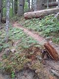
Things go pretty uneventful for a while from there. I made High Bridge at 09:00, Tenas Camp at 09:09 and 4 1/2 Mile Bridge at 09:16. But here, I had to make a note (I kept sort of a journal through most of my hike); people are actually saying hello to me and smiling! I've been worried for a while because the last 3 times I've taken the ECT, people seemed to be ignoring me and saying hello to those who were with me. Granted, I tend to have lots of large blades visible (machete sticking out over the shoulder, knife on either hip, hatchet and field-spade hanging from pack) but I'm a nice-enough guy. I wondered if people didn't say hi because I looked imposing or because I was usually the one in the front of my 'group'. But this time, I was by myself and I wasn't covered in so many blades - and people were saying hi to me! It really makes me wonder heh. Is it coincidence? Is it the lack of blades? Is it because I was alone? Who knows? I'm just glad they said hi to me, it's nice to hear other voices on the trail.
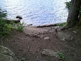
09:32 I made Wy'East camp (my previous farthest point of penetration on the ECT). There used to be a rickety old bridge just before it but it looks to have been completely removed and replaced by a patch of rock and dirt-pack. I was sort of saddened; I like rickety old bridges (that aren't high off the ground heh) and it was shedding some nice pieces of wood for starting up a campfire haha. I assume that's why it was taken out though and this is indeed a positive thing. Someone could've hurt themselves eventually (if they hadn't already) and improvements to the trail are a good thing.
09:42; I'm now in unfamiliar territory and I come across none other than the nice older guy and his pack-pup standing by a wooden box talking to a couple other folks. The other folks were planning to do the same hike I was and the guy standing by the wooden box was filling out forms for where people were going and on what trails, so that the most-used trails can get the most funding for repairs and improvements. So, of course, I agreed to fill out the paper (which is a Wilderness Use Permit and required - it turns out) because I want to do what I can to help these trails out (I've applied to be a volunteer for PCT trail maintenance, I need to do the same for ECT since it's infinitely more accessible for me). The guy-with-dog attached a "luggage tag" with all of my info onto my pack, wished me good trails (not quite what he said, but same difference) and I was on my way - the other couple already gone ahead.
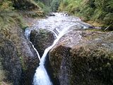
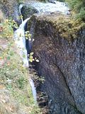
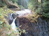
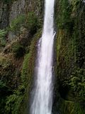
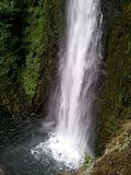
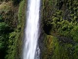
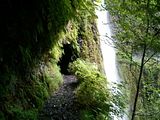
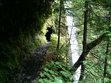
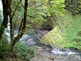
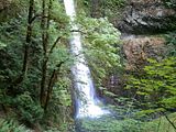
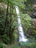
Still moving right along, I made the Eagle Creek - Eagle Benson trail junction by 09:47, tromped through the talus slopes and the very neat "Potholes", snapped a pic of Grand Union Falls at 10:05 and made my way toward Tunnel Falls. Now, I have seen pics of a lot of these places online but absolutely nothing is like the real thing. When I got close enough to truly see Tunnel Falls, I immediately stopped where I was and said, "whoa". What an absolutely beautiful waterfall - and tall! I also took some photos of the falls but they don't do it any justice. 10:14 I came out the other side of the tunnel, soaked up the spray for a moment and carried on. I took some video of going through the tunnel but the best photo opportunity came after exiting the tunnel and going down the trail a little farther. Everything opens up and gives you an amazing view of the falls from head-to-toe. I would have stood there all day admiring but I noticed another person coming up the trail so I moved on (I'm pretty shy, so sometimes I'm quite socially-reluctant).
The waterfalls just keep on coming! That's gotta be one of the best things about the ECT, all the beautiful waterfalls. Up next, I landed at Twister Falls at 10:20 and paused for a moment to take a picture and converse with the person who had been behind me at Tunnel Falls. It was nice to say hi to somebody else for a moment but he seemed equally reluctant so I bid him good hiking and carried on. He must not have gone much farther because I didn't see him again. After Twister Falls, we come to the 7 Mile Falls at about 10:28. Down near the base of those falls I saw a neat cave embedded into the rock that looked to have been used for shelter a few times. If anybody knows of the cave (I didn't get a picture) and knows an acceptable way down to it, I'm all ears =D. At 10:45, I strolled in to 7 1/2 Mile Camp for my next rest and meal period. Lunch time!
It seems like the trail is going by so much faster than it has the previous times, but then it's probably a little easier and quicker each time. Also, the previous times I was looking for places to stop to rest before turning back, or somewhere to camp for the night. That was "walking to get somewhere" and like I said, "I arrived somewhere to go walking". Every time I'm out hiking or doing long walks in the city, being close to my destination always seems to sap my energy and drag time out farther. Since my destination is the end of a large loop, I didn't feel that for a long long time (at least it seemed like it).
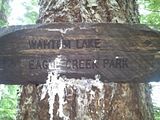
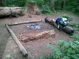
My lunch break at 7 1/2 Mile Camp was pretty uneventful, I had some cold summer sausage, a power bar, a handful of Skittles and some water. I was starting to feel a bit sore so I took some Ibuprofen (thanks to my lovely girlfriend for making sure I had some!) and relaxed for a few. I started feeling quite cold due to the sweat on my clothing and I soon got tired of shivering and made ready to leave. I got up and walked around the camp site for a few, windmilling my arms, high-stepping my legs and doing some stretches to get the heat going again - and by 11:42 I was loading up and heading back out. Wahtum Lake or Bust! (what does that mean?)
By this point (11:51), I've drank 1/3 of the fresh water I had packed and feelin pretty good, when my left knee starts to develop a painful twinge. This is where I should have turned around and gone right back to the campsite to get some rest and wrap my knee up but I did the foolish thing and kept going. Right there was the biggest on-trail mistake of my entire trip and proved the deciding factor for the difficulty and comfort levels to follow. Oh hindsight, you can be so cruel. So I kept going and came across someone coming back the other way (he had passed me when I was having lunch), which should have made me think about turning around - but of course the thought never crossed my mind.
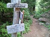
12:04, still trekking along, passing the Eagle Creek - Eagle Tanner Trail junction. A few more minutes up the trail (12:16) and I see a couple of familiar faces! The couple I came across back when I was filling out the wilderness permit - the ones who intend to take the same route that I had planned. They looked to be filling up their water containers and I showed them my maps and trail log to help them plan out their water consumption and their stopping point for the night. As for myself, I planned to trek through to Wahtum Lake and make camp for the night there, so I kept on down the trail. About 12:25 I came across a tree downed across the trail. It looked fresh and wasn't too massive, so I finished the job and yanked it off the trail and sent it down the slope a little ways.
12:56 and this is getting difficult. This part is a lot of uphill, followed by more uphill - and my knee is really hurting. I'm starting to think I should stop early at one of these campsites to wrap my knee up. 13:04, I came around a corner to a point on the trail that had an amazing view and an even more amazing breeze. I stopped dead in my tracks and felt instantly calmed and relaxed. I marveled in this lovely spot for a few minutes before reluctantly moving on - though thoroughly invigorated by my break. At 13:20 I decided to pull out my trail log and map to find my location when I see on the log, "Inspiration Point" and I had apparently just passed it. So that's what that beautiful spot on the trail was, very aptly named. I definitely felt inspired to go on - and go on I did!
It's about 13:34 and by this time my body is starting to accept the idea of continuous uphill hiking, when I come across a lovely little trickle of water running down some rocks on the right of the trail. So I took off my floppy hat, soaked it in the nice cool water and bathed all of my exposed parts. Then I rinsed my hat out and had a nice cool/wet hat to wear. It also worked nicely as a sweat mop for a while =D. Then, moving on. At 13:50 I finally found myself a good, stout walking stick. This definitely helped take some of the weight from my knee (which hurts even now as I type this) but it also helped bring my optimism levels back up, which might be more important than the pain relief. A positive mindset is very important in ventures like this. I'm sure enough of you remember the Swamp of Sadness in The Neverending Story where Atreyu lost his horse. You gotta stay positive!
14:01, the rocks and plant life are really starting to look different. The rocks are looking a little more volcanic and the grasses were little clusters of long-leaves (like those little fiberoptic-strand lamps) and spread about sparsely, as opposed to the solid angular rocks and thick brush I was used to. I arrive at the Indian Springs Trail junction and campsite. There wasn't much here to interest me but again, I should have stopped. I intended to stop here and wrap my knee up but of course I didn't. I did sit for a moment and drink some water, then I re-wetted my hat, wiped down my arms and face and decided to push through. *facepalm*
Nothing much happened for a while, though I did make a couple of "journal entries", which I will just type here - rather than converting them to past tense.
14:33 - "Not much in the way of signage after 7 1/2 Mile. I saw an 8mi post and I think I've been going off my printed materials since. Uphill to Wahtum, might have to steal a camp table heh [this, I meant, as opposed to paying for camping]. I think I lost the last couple that was following, they were probably stopping at Indian Springs for the night they said. Gettin cold up here..."
14:54 - "It's very slow going now. Limping uphill over rocks, not fast ha. I'll get there though, then, I feast!"
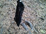
I read the sentence about my "feast" at least a few times, just trying to maintain my positive attitude, which was quickly slipping. However, I found a boost! At 15:05, I came across something quite unexpected. I crossed a stream trickling across the trail only to come to a stop in front of something black and lacy (panties? a thong? a garter?) stuck to a stick and stood up in the ground - like a flag. I immediately burst out laughing, grateful for the lift to my spirits (maybe some other spirits would have helped... next time I pack a flask of whiskey). I didn't move the totem though, I left it for anybody else who might have been coming or going and the next little while down the trail was occupied by humorous visions of how that item may have come to be there.
At 15:29, my knee and my thirst were getting the better of me so I had to take a break. I took a naproxen sodium tablet for the pain, drank plenty of water, had a power bar and took a 15 minute breather. 15:47, I was back on the trail and anxious to make Wahtum Lake. Looking back, about here is where my mind went from "got somewhere to go walking", to "walking to somewhere". Everything was a destination and everything seemed to be farther away than it should have been. I couldn't think about the very end of my trip anymore because I was too tired and in too much pain to think about anything beyond where I was going to find relief for one or both of those states. Mistakes turn into mistakes, which breed litters of mistakes.
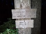
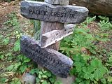
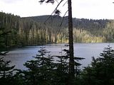
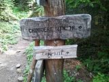
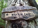
At 16:15 I made the junction that said, Short cut to North Bound P.C.T. and Chinidere Mtn. Tr. Some more hindsight, I should have taken this trail and said screw Wahtum Lake altogether. But, I didn't. I had been to Wahtum Lake before, but we got there by car and didn't actually go down to the lake as we were just scouting out the campground. Though we did take the trail out of the upper campground that looked like a vehicle road (probably only rarely used by quads or trucks for maintenance, but I don't think it's a vehicle road heh), but we took it in the car and damn near got stuck. I had to build a turnaround and we only managed because we have a Subaru Outback. But that's a story for another time lol. Moving on! By 16:20 I was getting my first good views of
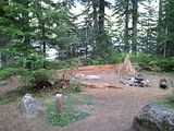
I arrived at the Pacific Crest Trail junction at 16:24 and finally got to set foot on the PCT! Hmm, still feels like dirt and rock, not a magical wonderland trail ;D. Well, I wanted the PCT, so I got it. At 16:35 I came to the Wahtum Express staircase-trail that climbs up to the campground. I should have skipped this too but I thought I'd be better off up top - I don't know why. At 16:47, I finally arrive at the top of the Wahtum Express, make my way to a table and plop my weary behind down on the seat as I let out a loud involuntary groan when the weight comes off my legs. It's definitely good to sit on "furniture". I made myself a temporary camp, changed clothes and wrote a couple more "journal entries", which I will just copy again.
17:12 - A completely fresh change of clothes (some warmer ones) and sitting for a few has made me feel a ton better. Now I just need to eat, rest and formulate the rest of my plan. My head is nice and toasty because my Honey thinks about me and had me pack a wool hat. And I have her Army Surplus "sleep shirt" =) <3.
17:39 - Well, I've decided it's too cold up here, with the sun going down, to try to sleep. I'm gonna eat/rest some more, then get back on the trail. I'll try to sleep when I find better warmth or I make it back to town ha. This may be a quick loop indeed =).
Had I been smarter about things, I would have realized that it was too cold to sleep at Wahtum Lake because I was ill-equipped for the temperatures around 3700-4100 feet and that I should turn around and take the ECT back because most of the rest of the trip was going to be up at this elevation. For some reason (even though I had the trail log with elevations for the entire trip) I thought it would get warmer as I got farther north on the PCT and I would find somewhere to camp. But that was not the case. I was a fool about too many things on this trip and I can still feel it. So, I got packed back up and got ready to leave.. but not before leaving behind a nice treble-hook fishing lure for someone else to use. I had brought it with me (just in case) but it was another bad idea and I decided to part with it. I don't own any other fishing gear so it wasn't a big loss lol. I left it on one of the signs up by the restrooms at the upper Wahtum Lake Campground. At 17:53 I was getting packed back up and 18:09 I was heading out.
I got on the trail that leads back to the PCT and as soon as I got back down by the lake (18:36) I saw some folks camping and holy mother they were cooking something that smelled delicious. Even though I had eaten my fill up at the picnic table, I had to stop and pull a pita out of my bag to snack on - that smell made me hungry all over again. I'm not sure what it was and I wish I had the nerve to stop and ask to join them, but they may not have had enough to share with a random stranger. The fire and anything warm in my belly would have been welcome, but as I said, I'm a shy idiot. So I hobbled on by after basking in the smell for a few moments.
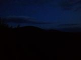
At 17:05 I saw my first clump of horse poo =D. Yeah, nothing exciting I know, but I hoped to run in to some people on horses. The poo did not look fresh at all though so I gave up on that - they were long gone. At this point, another terrible idea occurs to me. It's getting dark and, guess what, I forgot my main source of light at home - my Maglite. So, in my brilliance, I decide I'm going to test my night-vision when it gets dark and see how far I can get without needing to use my other lights (a couple of smaller LED lights, one a headlamp that my ever-thoughtful girlfriend provided). Until then, I continue trudge along through the lessening light.
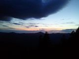
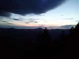
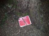
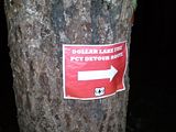
Back when I was filling out the Wilderness Permit, the guy had asked me if I was going North or South on the PCT. When I told him North, he said that was good because I'd have to walk a loooong way to get to PCT South. He didn't, however, elaborate on why lol. At 19:33 I came across a sign that said there was a large detour for PCT South due to the Dollar Lake fires. So that's what the guy meant lol. Good thing I wasn't going that way. Carrying on, I had to stop at 19:44 to take some pictures of a beautiful sunset. Then it started to get dark and the test of my night vision (natural, not goggles) began. It was really no surprise when 19 minutes later I had to strap on my head lamp =D. There's no way I could make it without light, I saw at least a dozen places along the trail that had washed out that I wouldn't have seen at all and went tumbling off the trail - potentially to my death. Some brilliant idea that was. However, that meant that I had only 2 small LED lights to work with and not many spare batteries (LEDs don't use much juice but the headlamp wasn't very bright unless the batteries were absolutely fresh and I needed both of my hands free), so I couldn't dawdle too much.
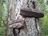
My mood was really starting to slip at this point. Insufficient light, getting tired from no sleep and an early start that morning and the general creepiness of the woods in a dark night (the moon was not yet up) all lent themselves generously to the shrinking of my hiking-spirit. From then on, it was no longer about the hike, it was about being done with the hike - which was the wrong way to think. My hopes came up once when I came to a sign that I thought meant I was transferring onto the Ruckel Creek Trail #405, which would have meant I was making better time than I thought and I berated myself for being so critical of my progress. Then, about an hour later when I got to the real junction to Ruckel Creek Trail #405, my heart sank. The last entry in my journal was at 22:30 when I got on the #405. I took no more pictures and wrote no more in my notepad, I didn't have the heart - I just wanted to be home with my Honey. But, to do that, I needed to make it off the trail. So, my strength renewed itself from my sense of need and I carried on, very weary.
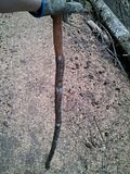
I don't know what times I got to any places since I didn't write them down, so the rest of my account is approximate. I plodded along the #405 for a while. At one point, I think I encountered a bear, but I can no longer remember which trail that was on or what time of night it was, so I will share that short story at the end. I made note on my printed trail log of the obvious features that I came upon on the trail but I missed much because I was just focused on where I was placing my feet and making sure each one kept going. The #405 became the most difficult for me when it started climbing back down from near-4000 feet. Earlier, my knee was acting up mostly on uphill climbs, at this point it was downhill that caused the pain and I had a lot of it to go. The walking stick I found probably saved my life because it kept me from many tumbles and was the only thing keeping me upright through some parts as my right leg would slip out and my left would not hold my weight. I might not have fallen off a cliff, but I might have fallen and broken something and succumbed to the elements, animals (unlikely) or hunger/thirst (thirst long before hunger, I actually had plenty of food). I'm definitely keeping this walking stick.
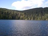
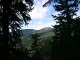
Eventually, the #405 turns into Switchback-Hell (at least it seemed like it with a bad knee, sore feet and thorough fatigue) which almost defeated me a few times. The thought to just stop, sit down and see what happens kept popping into my head but I couldn't do it. A few times I stopped to rest my knee for a second and woke up seconds later leaning on my walking stick, about to fall over. Eventually (I have no idea what time), I came to 1 of 2 shelves that overlook the Columbia River and wow what a view! I was able to (somewhat) detach myself from my discomfort long enough to enjoy the view for a moment but I felt sleep drag at me as soon as I stopped, so I got back to the trail. I continued down the switchback for a little way until I came to a second shelf that overlooks the Columbia and this time I stopped. I knew that one of the two shelves should be the "Columbia River Viewpoint" that was listed on my trail log and it was marked at 23.8 miles (of the total hike). I was so close but there was still a ways to go and I couldn't make myself go back to the trail. So I dropped my bag on the ground, pulled out my meager blanket and "pillow" (a thin seat cushion) and tried to curl up enough to be warm enough to sleep. Then, I started feeling clouds hitting myself and my pack (not rain falling, but clouds forming - there is a difference lol) and I didn't want all of my stuff getting wet, so I tried to adjust my position to fit my pack in under the blanket. I had a wall of roots and dirt behind be to keep the wind off that side but I couldn't get myself and my bag covered completely with my legs stretched out, so I tried to pull my knees up closer and received a cramp in each leg for my troubles. From there all I remember is wrestling around with the blanket, the pillow, my pack, the wind, the ground and my leg cramps - trying to find a position to get some rest, then waking up sometime after 05:00.
Just thinking about that ledge makes me cold while I'm typing this. After I woke up, I decided that I had rested enough and I was getting off this hill! I was still damp from sweat and quite cold (I should have changed my clothes or attempted a fire), so I wrapped my blanket around my torso before putting my hoodie back on over it. After strapping my bag back on, adjusting everything and getting moving, I warmed right up! The blanket under the hoodie was lovely for a while. It was fully sun-up when I reached the Powerline Clearing and that's when I really started feeling positive again. Though it was still incredibly slow-going downhill, I gritted my teeth and did my best to ignore the pain so I could make better time. I wended my way down and eventually the trail got easier and after a while, I spotted pavement!!!!!!!!!! I stopped where I was, yelled out (very loudly) "Thank $#&% god!!!", put my stick to the dirt and get the hell off the hill. I've never been so happy to put my feet on paved road in my life.
I wasn't sure which way I was supposed to go from here, so I took a right. That went uphill, which I was not happy with, but I thought that's the way I needed. After a few minutes of seeing nothing but a sign for a park, I took my pack off, set it down on the side of the road and dug my phones out so I could swap out (the one in my pocket was dead and the other had fresh battery) and find my location on GPS. I made the mistake of laying down on the road, with my head on my pack, for a moment while my phone was loading some maps and I woke up several minutes later lol. However, my maps were loaded and I knew where I was, so I got up, slung up my bag and went back down the road - the way I had come from ;D.
So I trekked back down what I had just realized was the HCRHT (the walking path that you see along I-84) and that I was essentially done. I actually skipped for a moment but it was too tiring haha. I didn't go all the way back to the trailhead, instead I went to the campground (the old trailhead) and refilled a water bottle. This is the first water I had that wasn't from my house on this entire journey. I drank the last of my water (started with something over 3 liters) after the Powerline Clearing on Ruckel #405, I did pretty well on rationing. After filling my water, I plodded over to the Eagle Creek Overlook group-camping area (this is where I have my family reunion every summer for years and just got to the ECT this year) and set myself up on a bench by the gate to watch some fishermen until my girlfriend arrived in her Subaru chariot of gold to take me home.
As far as the "bear encounter", thinking it over, I believe it was somewhere between the PCT/Ruckel-#405 junction and the Hatfield Wilderness Boundary. There was a stretch that I can only recall as surreal. It didn't look like any part of Oregon I'd been in (this may have been the fatigue and poor vision talking). This is what happened:
I was walking down a track with large trees all around but not much in the way of underbrush. I happened to look up from the trail and see a large pair of glowing eyes (yes I know it was the reflection from my headlamp) a few feet down the trail from me. I was making no effort at being quiet and I had music playing out of a speaker, so I'm sure I startled it. It darted across the path from my right to my left and I felt a slight tremor in the ground at its passing. It was just beyond my vision so I couldn't see clearly what it was, but I did see a "body" cross the trail behind those eyes. I can only surmise that it was a bear, a short elk or a very fat deer. Though it seemed to be in front of me for several minutes, it was across the trail to my left and gone in a couple of heartbeats and I leaped behind a tree to my right. I peered out on either side, I didn't see any charging animal. I jumped out and banged my stick to the right side of the tree and yelled, jumped back behind it and did the same thing to the left, but in a different tone. Hoping it would think there was 2 of me or that I was bigger than I am. I have no idea what it thought, I saw no sign of it again. After a few more heartbeats, I got back on the trail and went on my way as fast I could hobble without stinking like fear or killing my leg. I think this is when I first started getting into the switchbacks.
----
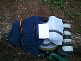
And that's my hike. What did I learn? What I do and don't need for such a through-hike. I had more "comfort" items than I needed and not enough "useful" stuff. I should have packed more water, warmer bedding, a tarp or something to keep dry and not forgotten my good lighting. I need to learn about and invest in some lighter, more comfortable gear for this sort of hike. Lighter yet more effective clothing and bedding, better shoes, some of those walking poles I saw most people with, a brighter headlamp and.. I should have rested somewhere. But, since I failed in preparation, I didn't have much choice but to push through and get out of the situation before it got any worse. Rain was on its way in, which I would have been caught in I think. Another thing I learned is to listen to my girlfriend more. Everything she had me pack, I needed (thermal sleep shirt, wool hat, pain pills, head lamp. Most of the stuff I packed, I didn't need. She recommended I take a trash bag or something, which I scoffed at - but could have been used to wrap my pack in so I didn't have to sacrifice any of my weak blanket.
It's all my fault, because I rushed this trip. It was a last-minute decision with last-minute preparation and that is never a good idea for something like this. I definitely intend to repeat this loop, but in better weather, with some company and better preparation. I absolutely recommend this hike.
Photos are in another post toward the bottom of this page. Sorry if that was too long to read.
Eagle Creek to Wahtum Lake 09/16/11 - 09/17/11
-
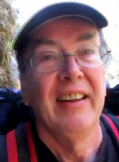
Dustin DuBois

- Posts: 789
- Joined: September 19th, 2011, 1:24 pm
- Location: Beaverton, OR
Eagle Creek to Wahtum Lake 09/16/11 - 09/17/11
- Attachments
-
Last edited by Dustin DuBois on September 22nd, 2011, 6:02 am, edited 2 times in total.
Hi!

Re: Eagle Creek to Wahtum Lake 09/16/11 - 09/17/11
Great write up and story! I laughed when you tried to fool a bear, not sure what it thought 
I still never been to Wahtum Lake, your trail description and times fills in the gap and will help me to plan my trip, maybe next year.
As for light-weight food, many people take freeze dried food to which you add boiling water at camp. It tastes quite good and weights almost nothing in the pack.
I still never been to Wahtum Lake, your trail description and times fills in the gap and will help me to plan my trip, maybe next year.
started with something over 3 liters
Nooooo! Unless you hike in a desert or a long streatch w/no water, it's much better to take a filter (this type or this type) and refill water from streams. I never take more than 1.5-2 liters, more often just 1/2 liter and a filter.I should have packed more water
YESI should have packed ... warmer bedding, a tarp or something to keep dry and not forgotten my good lighting.
As for light-weight food, many people take freeze dried food to which you add boiling water at camp. It tastes quite good and weights almost nothing in the pack.
-
Dustin DuBois
- Posts: 789
- Joined: September 19th, 2011, 1:24 pm
- Location: Beaverton, OR
Re: Eagle Creek to Wahtum Lake 09/16/11 - 09/17/11
I'm not sure what I thought, trying to fool whatever it was, either lol! For all that I "suffered", I had a blast and I definitely need to make sure I'm properly prepared next time.
Those filters you linked are awesome! I'm definitely going to pick one up and minimized my camel-ness.
I have a lot of investing that I need to do, I basically prepared with what I had laying around the house and stuff from my "outdoor" gear - which isn't much.
But good suggestions so far; I'm gonna get a filter and I can totally eat "MREs" and other insta-meal type things - I just gotta get 'em. So over the winter, I'm going to be getting advice and researching and building up some better gear for next dryer season, so I can do bigger and neater hikes.
Thanks for the tips!
Hi!

Re: Eagle Creek to Wahtum Lake 09/16/11 - 09/17/11
WOW....You made though & are a true trooper, what a great report!
Shoe Shine Boy Has Left The Building!

Re: Eagle Creek to Wahtum Lake 09/16/11 - 09/17/11
An entertaining account of your initiation! It takes time to whittle things down to the necessary but still retain a little comfort - the usual trials and errors. In certain places, where I know I can water from springs, I don't even take a filter although it's probably necessary anywhere in the Gorge. I'd suggest weighing your pack and trying to pare it down a little each time (lighter food, less extra clothing, etc.).
John
John
-
Splintercat

- Posts: 8333
- Joined: May 28th, 2008, 10:03 pm
- Location: Portland
- Contact:
Re: Eagle Creek to Wahtum Lake 09/16/11 - 09/17/11
Great report... er... not sure I want to call you "HeadIdiot"..! Welcome to Portland Hikers!
So, as I understand your report, you hiked all the way up to Wahtum Lake via, then back on the PCT to somewhere on the Ruckel Creek Trail switchbacks for a few hours of sleep, then finished the loop to the Eagle Creek trailhead..? Wow! That's quite a hike! A bit harrowing, given your saga, but glad you made it, and glad you're already thinking about your next trip! Love the "fat deer" encounter, too..!
-Tom

Re: Eagle Creek to Wahtum Lake 09/16/11 - 09/17/11
I think Friedrich Nietzsche said it best: "That which does not kill us makes us stronger." IMO definitely applies to hiking. But I suppose we also can evaluate and learn from our experiences as we go along, and make better choices.
Your experiences sounds like quite an adventure! I remember one of my first trips up Eagle Creek to Wahtum many moons ago... I was toting a huge 'Rambo' knife on my hip. People gave me some odd stares, me and my knife. I bet the same applied to you, during the times you were packing so many blades.
As for gear choices - it's hard to know exactly how much warm clothes and such that you'll need. Best to plan for the worst. And learn from mistakes... BTW those cheapy mylar space blankets can truly be life-saving (or at least 'trip-saving') items. Fragile and noisy, yes, but they do hold in heat. I always carry two of them, along with a 5x7 emergency survival blanket on day hikes, backpack trips, etc. Don't hit a trail without one, is my motto. Works for a zillion things - taking a nap, staying warm, fending off a rain shower, and probably even emergency signaling too.
Water! This year I finally took the plunge and started using an inexpensive hydration bladder for water. Best thing I've ever done. Great way to stay hydrated!
I really, really enjoyed reading your trip report, HeadIdiot! Great story. Can't wait to see your pictures.
Your experiences sounds like quite an adventure! I remember one of my first trips up Eagle Creek to Wahtum many moons ago... I was toting a huge 'Rambo' knife on my hip. People gave me some odd stares, me and my knife.
As for gear choices - it's hard to know exactly how much warm clothes and such that you'll need. Best to plan for the worst. And learn from mistakes... BTW those cheapy mylar space blankets can truly be life-saving (or at least 'trip-saving') items. Fragile and noisy, yes, but they do hold in heat. I always carry two of them, along with a 5x7 emergency survival blanket on day hikes, backpack trips, etc. Don't hit a trail without one, is my motto. Works for a zillion things - taking a nap, staying warm, fending off a rain shower, and probably even emergency signaling too.
Water! This year I finally took the plunge and started using an inexpensive hydration bladder for water. Best thing I've ever done. Great way to stay hydrated!
I really, really enjoyed reading your trip report, HeadIdiot! Great story. Can't wait to see your pictures.
-
MarkInTheDark
- Posts: 220
- Joined: August 11th, 2008, 3:58 pm
- Location: Portland, OR
Re: Eagle Creek to Wahtum Lake 09/16/11 - 09/17/11
Great report, what an adventure!
-
Dustin DuBois
- Posts: 789
- Joined: September 19th, 2011, 1:24 pm
- Location: Beaverton, OR
Here are the photos!
Aside from a couple blisters, I'm pretty much recovered =D. I'm not sure how much good my knee is going to be until next year, I'm gonna take it easy on it for a while just to avoid any long-term damage (if there isn't already heh). I won't be sitting around for long though, I'm already itching to get back on the trail - even for just a quick day-hike.
As far as the emergency blankets, my girlfriend suggested those too loo, which I also scoffed at. Next time, I should just let her fill my pack and hope for the best =D. I bet I find an emergency helicopter inside.
Thanks for all the great responses! I'm glad you guys like the account of my "adventure", though I'm sure it pales in comparison to many of yours ;D. Now that I'm feeling good again, it was nothing but fun, learning and exercise lol. I'll try to keep making logs and taking pics on my hikes to come share them here and collect some more great feedback =D.
---------------------
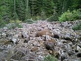
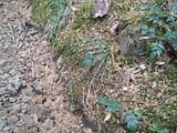
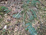
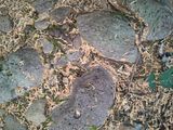
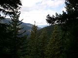
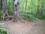
Anyway, here are the photos! Descriptions are in the file names. Click the thumbnails for larger images, though not full size (I have full-size of all of them available, just send me a PM on the site) - Photobucket resized my images. A couple other image hosts didn't resize them, but they wouldn't leave the file names alone or give me a nice handy list of links either. I think I'm just going to use my own web host next time heh. Also, for some reason, it's starting with the last image first. So at the beginning, you'll see the last photos I took lol.
-----
Also, I uploaded a couple videos of Tunnel Falls to YouTube. Check 'em out. (Sorry if the sound is horrible, I'm only working with a cell phone)
Going through Tunnel Falls: http://www.youtube.com/watch?v=L1w53su8zRQ
Top-to-Bottom of Tunnel Falls: http://www.youtube.com/watch?v=D47y_Iepkr0
As far as the emergency blankets, my girlfriend suggested those too loo, which I also scoffed at. Next time, I should just let her fill my pack and hope for the best =D. I bet I find an emergency helicopter inside.
Thanks for all the great responses! I'm glad you guys like the account of my "adventure", though I'm sure it pales in comparison to many of yours ;D. Now that I'm feeling good again, it was nothing but fun, learning and exercise lol. I'll try to keep making logs and taking pics on my hikes to come share them here and collect some more great feedback =D.
---------------------
Anyway, here are the photos! Descriptions are in the file names. Click the thumbnails for larger images, though not full size (I have full-size of all of them available, just send me a PM on the site) - Photobucket resized my images. A couple other image hosts didn't resize them, but they wouldn't leave the file names alone or give me a nice handy list of links either. I think I'm just going to use my own web host next time heh. Also, for some reason, it's starting with the last image first. So at the beginning, you'll see the last photos I took lol.


-----
Also, I uploaded a couple videos of Tunnel Falls to YouTube. Check 'em out. (Sorry if the sound is horrible, I'm only working with a cell phone)
Going through Tunnel Falls: http://www.youtube.com/watch?v=L1w53su8zRQ
Top-to-Bottom of Tunnel Falls: http://www.youtube.com/watch?v=D47y_Iepkr0
Hi!
Re: Eagle Creek to Wahtum Lake 09/16/11 - 09/17/11
Wow that is some report. You might find some practical information for lightening your load and saving your knees/feet at: http://www.hikelight.com/videos.html
Steve, the publisher of the videos operates out of Troutdale and sells some of the nicer gear around.
Hope to see you on the trails.
Steve, the publisher of the videos operates out of Troutdale and sells some of the nicer gear around.
Hope to see you on the trails.