11/24/12 Table Rock Wilderness & Exploration *Molalla Status

This forum is used to share your experiences out on the trails.
User avatar
mileagemike25000
Posts: 475
Joined: February 8th, 2012, 7:40 pm
Location: Vancouver, WA

11/24/12 Table Rock Wilderness & Exploration *Molalla Status

Post by mileagemike25000 » November 26th, 2012, 7:06 pm

We just intended on heading out to the Molalla Recreation area with the intention of an easy, but beautiful, hike. :) As soon as we reached the area we noticed that there were signs indicating that the area was being logged, a seemingly long term ongoing project. :shock: We first saw a sign at Amanda's Trail TH. After seeing this we got a bit disgruntled and decided to continue driving up the road. We did see a truck parked at the Hardy Creek parking area, but again decided to try our luck further south. After seeing a few more signs for logging we decided to continue on to Table Rock Wilderness. We love this wilderness but it did cost us an additional 20 minutes of travel time. :x

We parked at the large gravelled area next to the gate, just off Middlefork Rd, SE of the Molalla River bridge.
1 Table Rock Wilderness Parking Area_(1).JPG
Note the yellow gate on the left of the picture. We had heard that there was a trail that had originated off this road, at one time. Being curious, we decided to check it out. :?

We started hiking past the gate and quickly passed many piles of gravel. At the end of this gravelled area is a dirt berm.
2 Explore past berm_(1).JPG
Walking past the berm the path turned into an obvious old forest road. As we ascended up the trail we were greeted by a nice view of a mountain to the north. :)
3 Nice view along the way_(1).JPG
As we continued there was evidence of exposure to humans, discarded junk. :x
4 Some discarded items._(1).JPG
Now this old forest road was full of leaves and felt like we were walking on plush padded carpeting. :D
5 Leaf covered old forest road_(1).JPG
And there was the occasional water on the trail, from the recent rain.
6 Trails a bit wet_(1).JPG
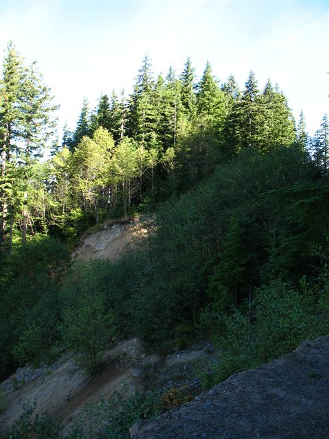
A ways up the road we observed a nice slide area where several trees had been knocked over.
7 Slide area took a few trees with it!_(1).JPG
After about one mile we came to the end of the road! There was no obvious way to go, and there was certainly no trail. :(
8 End of the road_(1).JPG
I remember seeing a trail/road on the GPS a ways back, but thought nothing of it since no spur trail was obvious. We turned around and looked for signs of some path up this gently graded slope. It appeared that there could have been something here, but it was long gone and had been reclaimed. :shock: We bushwacked up this gently graded area but found nothing obvious. Oh well, it was worth the effort to check out the story!
9 Investigated a possible trail that was on gps_(1).JPG
Heading back to the parking area we turned to the left and ascended up the Table Rock Wilderness Trail. The Wilderness check-in is less than 1/10 mile up the trail.
10 Wildernes sign-in on real Table Rock Wilderness Trail_(1).JPG
At this point my goal was to reach a nice outcropping with a fantastic view of the surrounding Mts.! For those that haven't been up this trail just know that the grade is mostly gentle and the greenery provides plenty of eye candy! :)
11 Nice stand of trees_(1).JPG
12 Plenty of moss on vine maples!_(1).JPG
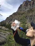
The temperature was cool with no wind, and a gentle rain was falling continuously for much of this portion of the hike. However, the real treat was the MOOD! :D As we ascended into the mist we were overcome by the surreal ambience.
13 The perfect mood for a hike!_(1).JPG
14 Where are the Trolls & Goblins and Hobbits!_(1).JPG
We never made it to the viewpoint, but then we didn't care since the hike was so peaceful. :D We never saw any hikers or hunters, which just added to the serenity!

The hike was 6.3 miles with an elevation gain of just over 1600ft.
Table Rock Wilderness & Exploration.JPG

User avatar
bobcat
Posts: 2771
Joined: August 1st, 2011, 7:51 am
Location: SW Portland

Re: 11/24/12 Table Rock Wilderness & Exploration *Molalla St

Post by bobcat » November 26th, 2012, 7:27 pm

Mike: That's the High Ridge Trail you went up from the Old Bridge Trailhead. The trail goes all the way past Rooster Rock (but not Table Rock) to the Pechuck Lookout. It was first used by Native Americans (to get to berry fields) and then by settlers as a route to Bagby Hot Springs. I recently entered a Field Guide page on this and other trails in the Table Rock Wilderness.

As for the road you first went up, I'm not sure there ever was a trail off it. The main access road to the Table Rock Trailhead goes up from the junction before you cross the bridge to your trailhead. The Table Rock Trail was lengthened by about a mile when the road dropped down the slope during the 1996 deluge.

User avatar
mileagemike25000
Posts: 475
Joined: February 8th, 2012, 7:40 pm
Location: Vancouver, WA

Re: 11/24/12 Table Rock Wilderness & Exploration *Molalla St

Post by mileagemike25000 » November 26th, 2012, 8:19 pm

Bobcat - Thanks much for the info on the trail names and history! :) I read your field guide page on this hike and found it informative and excellently written! After reading it I can't wait to do the entire trail to Rooster Rock, in the summer months.

I see now that there isn't a trail that spawns from this road. I do remember talking with someone, in years past, about some trail that used to start from that road but has been decommissioned? If nothing else, it was an interesting exploration and worth the small effort. It's very interesting about the trail being lengthened due to the road dropping down. Where do you, and others, find the interesting historical information on the trail system history?

User avatar
BrianEdwards
Posts: 2405
Joined: February 2nd, 2010, 1:32 am
Location: Oregon City, OR
Contact:

Re: 11/24/12 Table Rock Wilderness & Exploration *Molalla St

Post by BrianEdwards » November 27th, 2012, 7:11 am

Well atleast im not the only one that's walked up an old forest road in search of something, only to find a lackluster end :P But hey, sometimes it's intriguing to find out where an old mossy road goes.

Regarding the logging, I too am tired of all the normally open areas up the Molalla being closed due to "logging." Hopefully next year things are opened back up
Clackamas River Waterfall Project - 95 Documented, 18 to go.

User avatar
mileagemike25000
Posts: 475
Joined: February 8th, 2012, 7:40 pm
Location: Vancouver, WA

Re: 11/24/12 Table Rock Wilderness & Exploration *Molalla St

Post by mileagemike25000 » November 27th, 2012, 5:59 pm

Brian - I'd like to think that great minds think alike! :lol: It was still very interesting and exciting to explore the possibilities.

Yeah, the Molalla Recreational Area is a nice place for winter hikes and this minimizes the possibility. I'm confused why they're taking so much time logging a small area that is used frequently by many people. :?

forestkeeper
Posts: 1291
Joined: July 23rd, 2011, 8:31 pm
Location: Canby, Oregon
Contact:

Re: 11/24/12 Table Rock Wilderness & Exploration *Molalla St

Post by forestkeeper » November 27th, 2012, 6:18 pm

Another nice TR Mike. That Table Rock trail is just a few yards from that yellow gate on the right. I hiked that trail to Rooster Rock a few years ago. When you see some black fungus growing on the tree trunks on the trail, you're on the correct trail. I weird thing was, I, along with my teenage son, was being tracked by something. As we hit some switchbacks approximately 1.5 miles ahead, we heard large branches being broke some 50 yrds from our location. We thought it was an elk or bear. Nothing appeared but the sounds followed us a couple of miles. Make sure you and your wife have some sort of protection. Also be wary of loggers that want to intimidate you. I was a few miles East of there on the way to Thunder Mtn when two loggers in a blue Ford p/u followed me for a few miles. Each time I stopped, they stopped. They happen to get in front of me and blocked the road, with no place to turn around. As I proceeded to take my M2 Carbine that houses 7.62 x 54 full metal jackets, out of the trunk, they quickly sped away. At that time, I also carried a .357 handgun with 180 gr bear rounds. What's this world coming to when you have to shoot your way to a trail. :roll: ;)

FK

User avatar
mileagemike25000
Posts: 475
Joined: February 8th, 2012, 7:40 pm
Location: Vancouver, WA

Re: 11/24/12 Table Rock Wilderness & Exploration *Molalla St

Post by mileagemike25000 » November 27th, 2012, 6:57 pm

ForestKeeper - Thanks. :) Wow! That's one spooky story! :shock: We've been on many trails, and in many areas, and have luckily never had the experience of being stalked. Perhaps a Cougar was stalking both of you?

We have always felt fairly safe, and haven't run into any loggers, but we always have a heightened awareness of our surroundings. Our general rule is to avoid people that appear to be questionable or threatening! At the end of this hike there was a pickup truck with two guys in the cab and four guys sitting in the bed, and they just drove off in the opposite direction after having watched us hike down the trail and put our gear in the car. I'm sure your experiences would freak us out, and hope it never happens. Hopefully, bear spray would be some minimal kind of deterrent, but probably not against a gun? :?

I'm hoping you, and all the other PH'ers, don't have any future experiences!

User avatar
renegadepilgrim
Posts: 585
Joined: October 15th, 2010, 8:11 pm
Contact:

Re: 11/24/12 Table Rock Wilderness & Exploration *Molalla St

Post by renegadepilgrim » November 27th, 2012, 11:54 pm

Nice TR...anyone know if this area gets much snow in the winter? Just curious as it's on my list of places to explore and thought I might try it out in January. Not afraid of a little bit of snow and I'll be hammock backpacking if I decide to stay overnight.

Although if Sasquatch is in that area, I might have to reconsider... :)
Travel and Outdoor Adventure Website: http://www.renegadepilgrim.com
Instagram/Tumblr/Twitter: renegadepilgrim

justpeachy
Posts: 3069
Joined: May 28th, 2008, 10:03 pm
Location: Portland, OR
Contact:

Re: 11/24/12 Table Rock Wilderness & Exploration *Molalla St

Post by justpeachy » November 28th, 2012, 1:43 pm

mileagemike25000 wrote:Where do you, and others, find the interesting historical information on the trail system history?
A lot of it is history that you just pick up along the way if you've lived/hiked in the area long enough. Many people remember the catastrophic destruction of their favorite trails (and trail access) from 1996. Some of the history can be picked up from hiking books as well. If there was a weather event or road closure that affects a hike in Bill Sullivan's book he'll either tell you about it in his next edition (or, if necessary, remove the hike from the book). Also if you look at older hiking books and older maps and compare them with current information you can often piece together some of the history yourself.

Here's a 2006 picture of the slide on the road to the Table Rock TH. It's a terrible photo, but see the edge of the road in the bottom foreground and that big yawing gap where the alders are growing? That's where the road used to be.

Image

forestkeeper
Posts: 1291
Joined: July 23rd, 2011, 8:31 pm
Location: Canby, Oregon
Contact:

Re: 11/24/12 Table Rock Wilderness & Exploration *Molalla St

Post by forestkeeper » November 28th, 2012, 2:23 pm

Hey Renegade. Yes it does get some good snow up there. I'm not sure what TR it is, but a believe last year at the end of winter I did my 1st snow hike at the main TH at the top of the hill. It is soooooo fun! Snow shoes are recommended but at that time it was fairly packed. Spikes are more recommended. I didn't have neither so when I came to a 5 foot snow cliff (the sides of where a stream flows through) I just crawled or bigfoot strided up the sides. Which was fun too but my pants got pretty wet. Hope this helps. :)

FK

Post Reply