I've noticed a couple of TR's lately on the "grand loop" from Coyote Wall to Catherine Creek and back:
http://www.portlandhikers.org/forum/vie ... =8&t=15110
http://www.portlandhikers.org/forum/vie ... =8&t=15086
It's an area I've visited for many years and love dearly, but also know that it's been exponentially growing in popularity, and is also a patchwork of public & private land, especially at the top of Coyote Wall.
I think I've found one uncertain section. According to the NFS Bourdoin/Coyote/Catherine Recreation plan, Atwood road is implied to be public access from Courtney Road all the way to Catherine Creek.
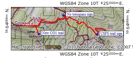
But according to the Klickitat GIS, Atwood Road is only public access from Courtney Road until it meets Cook Road (also public). And the road extending East from this intersection, which has been called Old Atwood Road, is called "B&B Road" on the Klickitat GIS-- and is designated as a private road on land owned by Adam Barton:
I think Kurt found this out accidentally when he was travelling counterclockwise on the grand loop-- only to find a "no trespassing" sign in his rear-view mirror at the intersection of Atwood & Cook when it was too late!
But it's an inevitable way to connect between Old Atwood Road and the top of Coyote Wall above Burns Farm and the vineyard. Does anybody know if it's OK to travel this section of Atwood Road thru Adam Barton's property?
Coyote Wall "disputed" territory
- chiefWright
- Posts: 101
- Joined: April 20th, 2011, 5:30 am
- Location: Marquam
- Contact:
- chiefWright
- Posts: 101
- Joined: April 20th, 2011, 5:30 am
- Location: Marquam
- Contact:
Re: Coyote Wall "disputed" territory
With Kurt's permission, I've highlighted on his GPS route map what I think is the private section of Atwood Road on Adam Barton's property:
- vibramhead
- Posts: 810
- Joined: November 15th, 2009, 10:52 am
- Location: SW Portland
Re: Coyote Wall "disputed" territory
I'd like to see this cleared up too. Perhaps the Forest Service recreation planner for the area, Stan Hinatsu ([email protected]) could shed some light on it.
Re: Coyote Wall "disputed" territory
When you do this loop counter-clockwise, as Kurt did, there's a USFS sign that implies that B&B Road is an acceptable trail. When you do it as I did, clockwise, the obvious route is to go down the B&B - except for the big no trespassing sign. The red track shows my attempt to follow the Green Trails map AND stay off private land; the yellow dotted line is where I think the USFS expects you to go.
Since this route shows up on the Green Trails map, it would be good to get this clarified (and the upper Atwood signed clearly) before there's an unfortunate hiker-owner confrontation this summer. Failing that, I would suggest folks take the CO2 use trail (which stays S of private land) and not try to make a loop using the NW portion of Atwood.
Re: Coyote Wall "disputed" territory
Yeah, I agree, that clarification would be great. That said, I have no doubt that we (inadvertently!) trespassed. We didn't find out, until we came to a sign pointing the other way. And that sign is along the segment you colored black, so I'd have to say that it seems the owners up there don't consider the western end of that road the same way they do farther east. There was no private property sign along the trail we took to get onto (what turned out to be) the Burns Farm driveway. Nor was there an indication that's what it was until we got to their signage farther north.
Please see this post for some photos of where exactly signs we saw were located.
Karl
Back on the trail, again...
Re: Coyote Wall "disputed" territory
After experiencing these issues a few years ago when I first explored this area, I now just stay lower and off those roads. That means that if I want to do a loop, I take the lower road that hits Coyote Wall at midpoint, making the upper part of the wall an out-and-back from there (now that the old loop with the canyon is closed). But the openness and sunnyness is one of the attractions of this area for me, so staying out of the forest and away from houses and improved roads is not a problem for me.
-
- Posts: 2
- Joined: December 23rd, 2015, 4:12 pm
Re: Coyote Wall "disputed" territory
Has there been any clarification provided by the forest service regarding this topic?