ZigZag Mtn Loop Sept 6th- with embedded photos this time!

This forum is used to share your experiences out on the trails.
Post Reply
User avatar
NWJeff
Posts: 40
Joined: September 2nd, 2008, 5:13 pm
Location: Hillsboro

ZigZag Mtn Loop Sept 6th- with embedded photos this time!

Post by NWJeff » September 9th, 2008, 11:11 am

This is a second post of my trip around ZigZag Mtns using attached photos instead of trying to link to a photo album. I'll post pictures of the alpine flowers I encountered in a second message.
-----------------------------

Last Saturday on Sept. 6th I hiked a 19 mile loop around the Zigzag Mountain area. I started from the Lost Creek trail for the Burnt Lake Trail (North). I went to Burnt Lake, East ZigZag Mtn., past Cast Lake, over to the West ZigZag lookout site, down to Devil's Canyon, and back to Burnt Lake and out to the parking lots.

I carried a 20+ lb. day pack, started at 7:00am and exited just before 7:00pm. Kind of a slow pace but it was was only my third week of hiking this year and I am stopping a lot more to check waypoints and snap photos. I took too much food, especially energy bars. I got by on three slices of hearty homemade wheat bread with cheese slices, a large sliced apple, one packet of Carb Boom gel, and three baggies of Gatorade for mixing with one quart of water each. I carried an old PUR Hiker water filter and usually carried one liter of water at any time.

A guide book I read said there was a stream for getting water around the Cast Lake area, but I never saw anything of the sort. I had planned to tank up and carry 2 liters from there until I got down past the lookout and near Devil's Canyon. So I was bummed and thirsty. But I was surprised to find a nice little drinking stream about a mile from the lookout.

View all photos from my ZigZag hike.

The first section is about 4.6 miles from the trail head to the Junction with the south side of Burnt Lake trail high on a ridge neat East ZigZag Mtn, and then on to the summit of East ZigZag with views of all the mountains.
P1020420.JPG
Burnt snags along the Burnt Creek as seen from the Burnt Lake (North) Trail. I sense a theme in this area!
P1020443.JPG
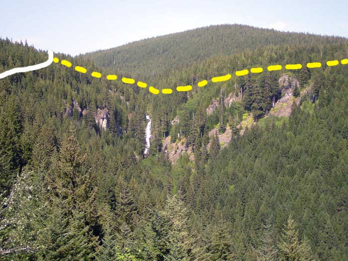
East ZigZag Mtn. Hidden behind the dip in the trail where it bends to the left is a white "temporary" sign marking the junction of this ZigZag Mtn. Trail with the Burnt Lake (South) Trail which heads down to Devil's Canyon.
P1020453.JPG
Mt. Adams as viewed from East ZigZag Mtn.
P1020454.JPG
Mt. Rainier as viewed from East ZigZag Mtn.
P1020455.JPG
Mt. St. Helens as viewed from East ZigZag Mtn.
The second section of the hike is about 4.7 miles from East ZigZag, down past Cast Lake and over to the ZigZag Lookout site.

P1020466.JPG
Trail climbs steeply from Devil's Tie junction toward another hilltop and ridge line.
P1020470.JPG
Mt. Jefferson looking south from a high meadow on the way to ZigZag lookout.
P1020490.JPG
Weathered log and boulders in a high meadow between Devil's Tie and the lookout site.
P1020508.JPG
West ZigZag lookout site looking south at Hunchback Mtn. Below is the Clackamas River valley, Hwy 26 and to the right is going west toward Sandy. Only the pillars remain. Ironic that a former fire lookout is now marked by the only campfire ring I saw on the entire hike.
The third section of the hike is about 10 miles from the lookout down to devil's Canyon, up the South Burnt Lake trail to the junction with the Zigzag trail on the high ridge viewpoint.
P1020533.JPG
Devil's Meadow
P1020551.JPG
The Burnt Lake (South) Trail is nearly invisible as it angles from the front center toward the right and tree line through tall plants.
P1020554.JPG
After a steep climb the Burnt Lake Trail (South) approaches the ZigZag Mtn. Trail junction on the high ridge above Burnt Lake.
P1020562.JPG
The rugged rock of Mt. Hood poking through the gathering evening clouds. As viewed from my supper break atop the high ridge trail junction.
P1020564.JPG
Looking down onto Burnt Lake from the high ridge top trail junction.
P1020565.JPG
Burnt Lake (North) Trail crossing of Burnt Creek, below Burnt Lake and heading back to the trail head.
THE END!

User avatar
NWJeff
Posts: 40
Joined: September 2nd, 2008, 5:13 pm
Location: Hillsboro

Re: ZigZag Mtn Loop Sept 6th- with embedded photos this time!

Post by NWJeff » September 9th, 2008, 11:46 am

Here are some of the alpine flowers I encountered and enjoyed on the hike.
P1020541.JPG
Little yellow tiger lily
P1020540.JPG
I don't know the name of this red flower but my wife thinks it looks like a ballerina.
P1020530.JPG
White flowers I have not seen before. Pretty.
P1020528.JPG
Light purple aster (?) with a speckled butterfly
P1020502.JPG
Indian paintbrush
And here is a map of the area with my initial waypoints marked. Click on the image and then zoom to see the detail. Most of the waypoints are spot on with reality. Z08 waypoint was supposed to mark the intersection of the Devil's Tie with the trail westward (not marked on topo map) to the lookout. The actual junction is about another 100 meters south of Z08.
ZigZag-loop-Jeff-2.JPG
West and East ZigZag Mtn, Burnt Lake, and Lost Creek trailhead

joerunner
Posts: 799
Joined: May 28th, 2008, 10:03 pm

Re: ZigZag Mtn Loop Sept 6th- with embedded photos this time!

Post by joerunner » September 10th, 2008, 5:07 pm

That is a great trip. Thanks for the photos.

pablo
Posts: 1451
Joined: May 28th, 2008, 10:03 pm

Re: ZigZag Mtn Loop Sept 6th- with embedded photos this time!

Post by pablo » September 10th, 2008, 6:26 pm

Very nice bunch of photos and accompanying descriptions. I wish the missus would let me stay out all night.

One thing about the map. The other day I was in TOPO! and for some reason hit the View/Live Map Updates... option and connected to Map eXchange and downloaded a ton of updated topo maps. Previously when I'd done this, I'd get back 'no updates' but this time huge numbers. I don't know how long these updates have been around but in some areas it really makes a difference, in the case of the ZigZag area, quite a bit. I think I see a lost trail - present on the older quad and gone from the newer, Devil's Canyon Trail - is this an abandoned trail?

In the newer map, trails are numbered and the missing section of trail between Z08 and Z11 is filled in with trail in the newer map.

What I've done is to keep TOPO on 2 systems because I like have the older topos available for lost trails investigations. It would be an easy configuration thing to have the new and old on the same system.

--Paul
newmap.JPG
Map as above but with updated 1997 Government Camp quad
The future's uncertain and the end is always near.

User avatar
Splintercat
Posts: 8333
Joined: May 28th, 2008, 10:03 pm
Location: Portland
Contact:

Re: ZigZag Mtn Loop Sept 6th- with embedded photos this time!

Post by Splintercat » September 10th, 2008, 10:36 pm

Thanks, Jeff - great report and great pics! One of my favorite areas.

Paul, that was a bonafide trail, though I'm not sure how intact it is. I've never been able to find the west end of it, but have thought about just searching the east end, where the junction would have been a bit easier to locate -- I've always been curious about how it crossed Devil Creek, given that this is a substantial stream for much of the year. Probably just a rock-hop, but given that there was a drive-in campground at Devils Meadow, there's a chance that it might have been a footbridge.

I've also scouted the upper part of Devil Canyon Falls - a wild drop that is impressive from any angle, but especially intimidating from above. Got as far as climbing down the upper 10-foot and 20-foot tiers, but then turned back as the yawning main drop opened up below. This is on my list for a bushwhack from the base -- hopefully, while I can still make it without a medivac rescue for the return trip! Here's a rough Madden-map of how the trail would have crossed the terrain:

Image

This is on the list of TKO trail proposals, BTW.

Tom

User avatar
NWJeff
Posts: 40
Joined: September 2nd, 2008, 5:13 pm
Location: Hillsboro

Re: ZigZag Mtn Loop Sept 6th- with embedded photos this time!

Post by NWJeff » September 11th, 2008, 8:23 pm

Thanks for the updated map example, Paul. I guess it is time to upgrade my Topo! Those new trail markings look exactly right. Plus, I notice the new maps have much more detail about campgrounds and trailheads, too.

MattC
Posts: 10
Joined: July 22nd, 2008, 5:59 pm

Re: ZigZag Mtn Loop Sept 6th- with embedded photos this time!

Post by MattC » September 13th, 2008, 3:19 am

Nice report and pics. ZigZag had been on my maybe list when I was visiting Oregon a couple weeks ago, but it never happened. Maybe next time.

The red flower in your second pic is Columbine.

Matt

User avatar
retired jerry
Posts: 14417
Joined: May 28th, 2008, 10:03 pm

Re: ZigZag Mtn Loop Sept 6th- with embedded photos this time!

Post by retired jerry » September 13th, 2008, 7:14 am

NWJeff wrote: A guide book I read said there was a stream for getting water around the Cast Lake area, but I never saw anything of the sort. I had planned to tank up and carry 2 liters from there until I got down past the lookout and near Devil's Canyon. So I was bummed and thirsty. But I was surprised to find a nice little drinking stream about a mile from the lookout.
Nice report and nice trip.

There is a stream just East of the junction of Devil's Tie Trail and Burnt Lake Trail, which crosses the Burnt Lake Trail.

As you go up the Devil's Tie Trail towards the junction with the Zigzag Mountain Trail (where Devil's Tie ends) and as you continue up the Zigzag Mountain Trail towards the Cast Lake Trail junction, the same stream is to the East of you. Later in the season, the stream flow reduces and you may have to go all the way down to the Burnt Lake Trail to find water.

Garlynn
Posts: 3
Joined: August 18th, 2014, 9:07 am

Re: ZigZag Mtn Loop Sept 6th- with embedded photos this tim

Post by Garlynn » September 15th, 2014, 11:23 am

Splintercat wrote:
I've also scouted the upper part of Devil Canyon Falls - a wild drop that is impressive from any angle, but especially intimidating from above. Got as far as climbing down the upper 10-foot and 20-foot tiers, but then turned back as the yawning main drop opened up below. This is on my list for a bushwhack from the base -- hopefully, while I can still make it without a medivac rescue for the return trip! Here's a rough Madden-map of how the trail would have crossed the terrain:

Image

This is on the list of TKO trail proposals, BTW.

Tom
I was up there yesterday, and it looks like there may be a way to access the base of the falls by climbing down a trail that starts at the cliffy viewpoint at the switchback on the ZigZag Mountain road from which you can see the falls. Since those cliffs appear to be at the same elevation and of the same formation as those that the falls fall over, I can imagine an old (perhaps Native American) foot track to reach the base of the falls from the base of the viewpoint cliffs. Haven't yet explored that possibility, however.

BTW, the falls should better be known as Spirit Horse Falls, and there was an effort by Native Americans in the 1990s to construct sweat lodges at their base, hold ceremonies, and thus show traditional use of the land to prevent the USFS from logging it. The other way to access the base of the falls is from the (now abandoned) road that points that direction from Zigzag Mountain Road near the bottom. This apparently involves a gnarly scramble up the steep creek bed from the end of the abandoned road bed, however.

Anybody ever accessed the base of the falls from either of those ways -- or another?

User avatar
fettster
Posts: 1720
Joined: May 28th, 2008, 10:03 pm
Location: Hillsboro, OR

Re: ZigZag Mtn Loop Sept 6th- with embedded photos this tim

Post by fettster » September 19th, 2014, 6:17 am

NWJeff, looks like the trail is tremendously overgrown at Devil's Meadow then? Is the underbrush pretty rough to brush against/through?

Post Reply