Devils Peak & Hunchback Mountain - 06/18/2010

This forum is used to share your experiences out on the trails.
User avatar
Guy
Posts: 3333
Joined: May 10th, 2009, 4:42 pm
Location: The Foothills of Mt Hood
Contact:

Devils Peak & Hunchback Mountain - 06/18/2010

Post by Guy » June 19th, 2010, 7:18 pm

We had the chance to do a car shuttle hike today and so set off to tackle Devils Peak from the Cool Creek Trail then hike down to Zigzag on the Hunchback trail.

I had never hiked the Cool Creek Trail before and was pleasantly surprised, I was expecting a relentless uphill slog in thick tree cover but the trail is quite open with some great view points and though it does climb about 3200 feet in 3.5 miles it spreads the climb out evenly over the whole distance. Our first unobstructed view of Hood as we made our way up.

Image

There is another great open area just below the Devils Peak summit at about 4800' with great views over in the direction of Hood.

Image Image

We ran into our first snow shortly after this but there isn't very much left!

Image Image

The peak itself is virtually snow free, the fire lookout was in good shape and based on the visitor log has been receiving a steady stream of visitors. We opened up a couple of the window shutters while we were there then closed the place up again before leaving.

Image Image

Taking the short spur trail to the South you get get some great views of Jefferson, & the Salmon Huckleberry Wilderness

Image

I believe this is the Devils Tooth?

Image

So here began part 2 of the day the 8 or 9 mile hike along the Hunchback trail to Zigzag, this trail is not for the faint of heart! in fact the first 4 miles from the lookout should be renamed The Trail of 10,000 Blow Downs!

Image Image

Most were easy to negotiate but they sure slowed us down and it seemed like an eternity until we reached this old sign just before the Great Pyramid, still 5 miles to go! To add insult to injury there is a relentless climb between this sign & the top of the Pyramid.

Image Image

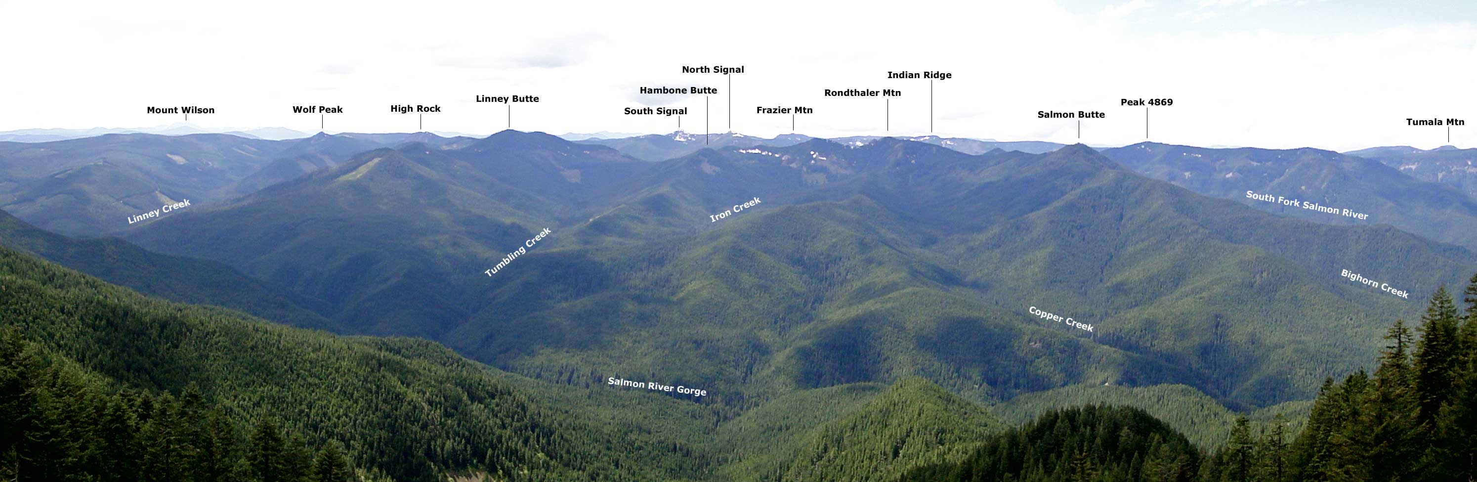
We took the now mostly overgrown Great Pyramid view point Spur trail & scrambled down a bit lower to get some views of were we had been, were we had to go & the Salmon River drainage.

Image Image

We also stopped at Helispot 260 viewpoint but the trees are slowly growing up around it.

Image

The final views were from the Rimrock viewpoint just before the trail finally begins its steep 2 mile decent into Zigzag.

Image Image

The final downhill can be a bit brutal on already tired knees! By now you are beginning to forget about renaming the trail the TheTrail of 10,000 Blow Downs & naming it The Never Ending Trail!

Finally a map & profile of our route from Eric's GPS. The profile is a bit hard to believe but all the other GPS stats seem to be right on! We know we were going up and down a lot along the Hunchback trail & perhaps it was also counting those hundreds of downed trees we had to climb over too but if the GPS is correct the cumulative elevation gain for this 13.5 mile hike is around 6900'!!

Image

Image

So in conclusion I'd say the hunchback trail is a tough hike but I'd still urge you all to go out & hike it, it needs more boots on it.

More photos of the trip live here.
hiking log & photos.
Ad monte summa aut mors

User avatar
pdxflowergirl
Posts: 589
Joined: March 6th, 2009, 12:47 pm
Location: Portland, Oregon
Contact:

Re: Devils Peak & Hunchback Mountain - 06/18/2010

Post by pdxflowergirl » June 19th, 2010, 7:57 pm

Guy wrote:and though it does climb about 3200 feet in 3.5 miles it spreads the climb out evenly over the whole distance
Um, Guy, that's still almost 1,000 vertical ft gain per mile! Looks like an intense day of hopping over logs...y'all are hard-core. I'm impressed! Thanks for the trip report. I definitely want to hike the first part up to the lookout tower. Looks like some amazing views.
Kam

User avatar
Splintercat
Posts: 8334
Joined: May 28th, 2008, 10:03 pm
Location: Portland
Contact:

Re: Devils Peak & Hunchback Mountain - 06/18/2010

Post by Splintercat » June 19th, 2010, 8:02 pm

Thanks, Guy - great report! Too bad to see so many logs down on the Hunchback trail, though. That's a lot of crosscut sawing, now that the entire ridge is firmly inside the wilderness boundary.

I'll date myself a bit, and mention that when I was in my teens (in the 1970s) the entire NE slope of Devils Peak (as seen in your second photo) was open, with just a few tiny trees. The view from the lookout was wide open in all directions but to the west, where the trees were already starting to fill in. You could also see down into the little meadow NW of the summit, at the head of Cool Creek -- not sure if you can see that now. I haven't hiked the Cool Creek trail in years -- last time I was up there was "cheating" via the short trail from Kinzel Lake...

:D

User avatar
retired jerry
Posts: 14424
Joined: May 28th, 2008, 10:03 pm

Re: Devils Peak & Hunchback Mountain - 06/18/2010

Post by retired jerry » June 20th, 2010, 5:40 am

"Trail of 10,000 blowdowns" Ha ha ha

I walked a couple miles down from the lookout last year and I agree, aptly named

Where'de you sleep?

I tried out the beds but they were very uncomfortable so I slept on the floor

Maybe next time, I'll sleep outside on the deck, or even down below on the ground

User avatar
fettster
Posts: 1720
Joined: May 28th, 2008, 10:03 pm
Location: Hillsboro, OR

Re: Devils Peak & Hunchback Mountain - 06/18/2010

Post by fettster » June 20th, 2010, 8:36 am

I definitely remember all those blow downs! There's gotta something about the lay of the land what whips the wind through there in the winter. There are some great views of the uncut drainage in that area and looks like you captured a couple. Did you get any shots of the Signal Buttes?

User avatar
Splintercat
Posts: 8334
Joined: May 28th, 2008, 10:03 pm
Location: Portland
Contact:

Re: Devils Peak & Hunchback Mountain - 06/18/2010

Post by Splintercat » June 20th, 2010, 9:06 am

Look way in the distance in the shot just after the Lookout photos -- they're just beyond Salmon Butte and (ahem) "Rondthaler Mountain"..! But there are some close-up shots on Guy's SmugMug set. Nice photos!

Tom :)

User avatar
Guy
Posts: 3333
Joined: May 10th, 2009, 4:42 pm
Location: The Foothills of Mt Hood
Contact:

Re: Devils Peak & Hunchback Mountain - 06/18/2010

Post by Guy » June 20th, 2010, 9:41 am

Cam: Yes The Cool Creek Trail is well worth doing & if you go up & down the same way it's only an 8 mile trip with lots of views. The trailhead is easy to get to but because it's just that little bit off the beaten path this trail is probably less used than it would be otherwise.

Jerry: We did this as a one day trip so we didn't stay at the Lookout, if we had I think I would have been on the floor though not on those old beds! Chiyoko told me she had no interest in staying there unless I went a day before her & cleaned it up first :) ..

Tom: Yes it will be a major job to clear this trail now, over the last few years I've had a big change of heart on no chain saws in wilderness areas & I'm thinking the main reason for this is to reduce human access to wilderness areas which I think is a great shame.
hiking log & photos.
Ad monte summa aut mors

User avatar
Guy
Posts: 3333
Joined: May 10th, 2009, 4:42 pm
Location: The Foothills of Mt Hood
Contact:

Re: Devils Peak & Hunchback Mountain - 06/18/2010

Post by Guy » June 20th, 2010, 9:49 am

Tom perhaps you and some others here can help me with some ID of the area looking South from Devils Peak as I'm not familiar with it:

First the view South over the Salmon Huckleberry Wilderness, anything you could point out in here would help, is your Rondthaler Mountain in here?

Image

The here is a closeup of the peaks that are in the middle of the shot above.

Image

And finally a wider angle pano

Image

Feel free to download these scribble on them & upload again!
Thanks.
hiking log & photos.
Ad monte summa aut mors

User avatar
Splintercat
Posts: 8334
Joined: May 28th, 2008, 10:03 pm
Location: Portland
Contact:

Re: Devils Peak & Hunchback Mountain - 06/18/2010

Post by Splintercat » June 20th, 2010, 2:35 pm

Guy, you KNOW I love those panoramas...! Here's the tiny version (unreadable), but click here for the large, scrollable version.

Image

I'm not sure of the ridge on the far horizon between Linney and South Signal -- could be Mt. Lowe, could be Fish Creek Mountain or Whale Head. I'm guessing the latter, but maybe one of the Clackamas groupies can confirm that one.

Neat!

Tom :)

User avatar
Guy
Posts: 3333
Joined: May 10th, 2009, 4:42 pm
Location: The Foothills of Mt Hood
Contact:

Re: Devils Peak & Hunchback Mountain - 06/18/2010

Post by Guy » June 20th, 2010, 3:29 pm

Hey Tom - That is so cool, thanks very much..
hiking log & photos.
Ad monte summa aut mors

Post Reply