
That must have been fun to build!
Bill
The Upper Latourell Falls mystery has been solved!

Re: The Upper Latourell Falls mystery has been solved!
Thanks for the great link. I use Salem Public Library Photo Archives when I'm looking for pictures. The 'Advanced Search' works really well if you know what you are looking for.Sore Feet wrote:Found the picture in the OSU Library's Digital Archives.
-
Introverted_hiker

- Posts: 14
- Joined: April 29th, 2009, 8:18 pm
Re: The Upper Latourell Falls mystery has been solved!
What a cool picture. Too bad that the trail and bridge are not there anymore. What a hike that would be. It's interesting how the way the angle of the picture is taken that the top tier of the falls looks really tall. When you're hiking up there and you directly face the falls from the front it seems so short. I wonder where this picture was taken from? Up in a tree or on one of the cliffs? Fantastic find.
-
Splintercat

- Posts: 8334
- Joined: May 28th, 2008, 10:03 pm
- Location: Portland
- Contact:
Re: The Upper Latourell Falls mystery has been solved!
Great find, Bryan! Scary, too... I'm not so sure I'd walk over that bridge..!  Run, maybe...
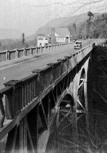
Okay, here's a theory -- and this is strictly speculation. But the thing about Latourell Falls is that it had two substantial road houses located where the parking area is now. Here's a photo showing the structure near the bridge, and a second building was located on the bluff where the paved trail now goes to the viewpoint with the bench and stone wall:
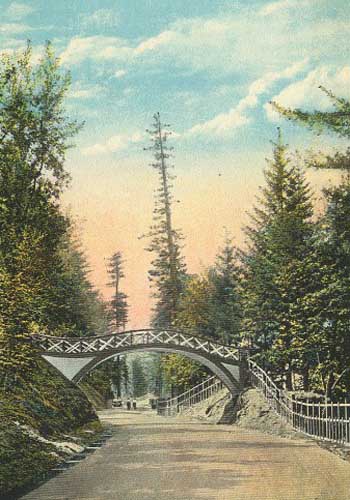
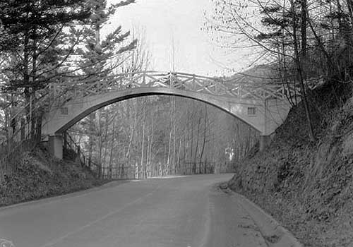
So, if you assume that these early developments included some footpaths to the falls, it's possible that the first trail up the canyon was built at about that time -- the east trail feels that way to me. But to add to the puzzle, there was once a rather ornate pedestrian bridge that crossed the Columbia River Highway just west of the Latourell Bridge. Here are a couple photos:
This bridge is long-gone, but it does suggest that the trail on the west side of the creek might have continued on up the canyon back in the day, since the trail to the falls from the west side of the creek (the other obvious destination) goes under the highway bridge. So, maybe if you assume that the upper falls loop trail is, in fact, quite old, then you've got a case for why the bridge was built at the mid-point of the falls, completing the loop.
A completely different theory is that the bridge was built on an opportunistic log that happened to be lodged at that point on the falls, explaining why the trail would come to the falls on the west side, then switchback up the hill instead of simply crossing at the base of the falls.
Fun stuff!
Tom
Okay, here's a theory -- and this is strictly speculation. But the thing about Latourell Falls is that it had two substantial road houses located where the parking area is now. Here's a photo showing the structure near the bridge, and a second building was located on the bluff where the paved trail now goes to the viewpoint with the bench and stone wall:
So, if you assume that these early developments included some footpaths to the falls, it's possible that the first trail up the canyon was built at about that time -- the east trail feels that way to me. But to add to the puzzle, there was once a rather ornate pedestrian bridge that crossed the Columbia River Highway just west of the Latourell Bridge. Here are a couple photos:
This bridge is long-gone, but it does suggest that the trail on the west side of the creek might have continued on up the canyon back in the day, since the trail to the falls from the west side of the creek (the other obvious destination) goes under the highway bridge. So, maybe if you assume that the upper falls loop trail is, in fact, quite old, then you've got a case for why the bridge was built at the mid-point of the falls, completing the loop.
A completely different theory is that the bridge was built on an opportunistic log that happened to be lodged at that point on the falls, explaining why the trail would come to the falls on the west side, then switchback up the hill instead of simply crossing at the base of the falls.
Fun stuff!
Tom
-
Splintercat
- Posts: 8334
- Joined: May 28th, 2008, 10:03 pm
- Location: Portland
- Contact:
Re: The Upper Latourell Falls mystery has been solved!
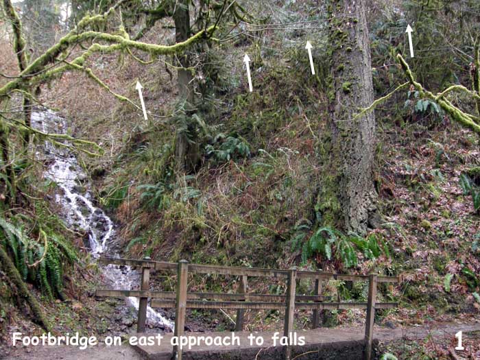
Bumping this up - had a little family hike on the Latourell loop this afternoon (along with every other family in Portland, I think!), and took the opportunity to examine the canyon walls around the upper falls. Here are some photos -- and as Bryan's photo of the bridge suggested, it's all hiding in plain sight. I've used little arrows to point to trail benches that remain, so that you can see them in the photos.
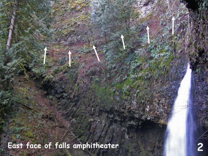
Beginning at the small footbridge over a side creek on the east side of the falls, there is the trace of a trail bench about 20 feet above the trail -- this is the most sketchy section:
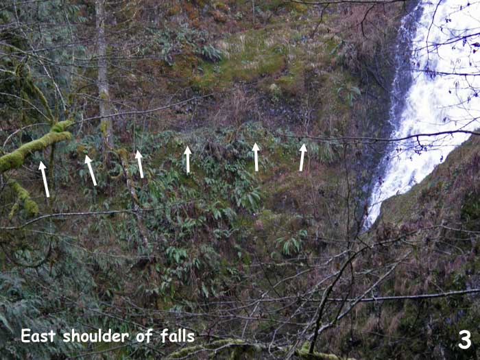
As the old trail closes in on the east side of the falls, it is cut into basalt, so very intact -- here are a couple shots of the cliff face on the east side of the falls:
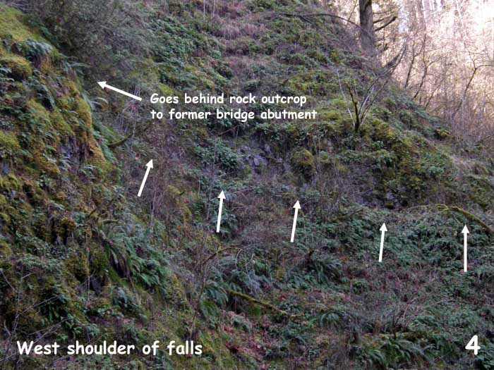
On the west side of the falls, the approach to the bridge ducks behind a rock outcrop on the falls face, but clearly emerges about 25 feet west of the falls, and begins traversing downstream:
A bit wider shot shows the trail heading into a small ravine, then continuing across the canyon slope:
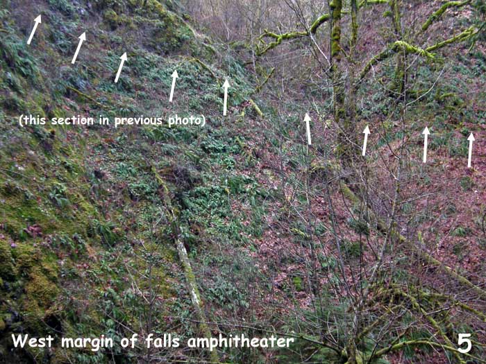
Here's the interesting part: there are clearly four (or more) switchbacks in the old trail as it climbs up the west slope of the canyon. But the trail heading to the old bridge across the falls departs in the middle - at the third switchback:
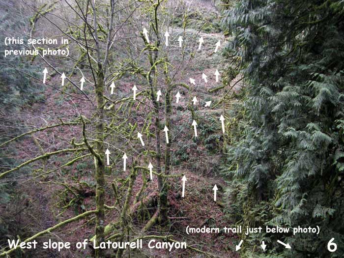
So, this lends credence to the idea that part of the trail went beyond the falls, perhaps simply to the road above.
I started to follow the west slope upstream... but alas, was with family, so no time on this trip. Next time!
Tom
Beginning at the small footbridge over a side creek on the east side of the falls, there is the trace of a trail bench about 20 feet above the trail -- this is the most sketchy section:
As the old trail closes in on the east side of the falls, it is cut into basalt, so very intact -- here are a couple shots of the cliff face on the east side of the falls:
On the west side of the falls, the approach to the bridge ducks behind a rock outcrop on the falls face, but clearly emerges about 25 feet west of the falls, and begins traversing downstream:
A bit wider shot shows the trail heading into a small ravine, then continuing across the canyon slope:
Here's the interesting part: there are clearly four (or more) switchbacks in the old trail as it climbs up the west slope of the canyon. But the trail heading to the old bridge across the falls departs in the middle - at the third switchback:
So, this lends credence to the idea that part of the trail went beyond the falls, perhaps simply to the road above.
I started to follow the west slope upstream... but alas, was with family, so no time on this trip. Next time!
Tom

Re: The Upper Latourell Falls mystery has been solved!
Great work Tom,
This has been on my mind since the old Bridge photo was posted. Definitely will be going to check it all out with your photos in hand!
This has been on my mind since the old Bridge photo was posted. Definitely will be going to check it all out with your photos in hand!
-
Splintercat
- Posts: 8334
- Joined: May 28th, 2008, 10:03 pm
- Location: Portland
- Contact:
Re: The Upper Latourell Falls mystery has been solved!
Excellent! I'd love to hear another take on this, Guy. There was a lot of trail up there at one time!
Tom
Tom

Re: The Upper Latourell Falls mystery has been solved!
Is it not cool when you look and old trails appear that most people never notice?
Freezer Bag Cooking, Trail Cooking, Gear & Beyond.....Outdoor Food Simplified: http://www.trailcooking.com/
Re: The Upper Latourell Falls mystery has been solved!
We had a couple of free hours today - just long enough we thought to go & check out the lost trails leading up to the "lost" Upper Latourell Falls Bridge.
My original plan was to check out the trails pointed out by Tom on both sides of the Falls but when we got there I felt there were just too many people on the trail for me to be seen clambering around in the undergrowth so I decided to skip the East side completely until a quieter day.
As for the West side I decided just to make a quick scramble straight up & see If I could intersect the trail which Tom points out in his photo. This was easily done & in just a few minutes a found myself here.

As you can see the old cable hand rail is still there too! I followed the trail around to the Falls.

And soon found myself looking across the Falls to the trail on the other side.


I retraced my steps to the washout that I'd scrambled up and tried to follow the trail to the junction where it continues to ascend but there was another washed out section so I would have had to scramble up the hillside in full view of a steady stream of hikers below so decided not to this time - I need to go back on a weekday morning! So there's still more to be discovered here on both sides of the creek.
About the ornate footbridge over the Highway that Tom posted photos of, you can still see the footings of this bridge just a few feet west of where the current trail returns to the highway:


The trail obviously continued on down off the bridge into Guy W. Talbot park, perhaps on down to these steps which are in about the right place:

A fun couple of hours of sleuthing was had ..
Guy.
My original plan was to check out the trails pointed out by Tom on both sides of the Falls but when we got there I felt there were just too many people on the trail for me to be seen clambering around in the undergrowth so I decided to skip the East side completely until a quieter day.
As for the West side I decided just to make a quick scramble straight up & see If I could intersect the trail which Tom points out in his photo. This was easily done & in just a few minutes a found myself here.
As you can see the old cable hand rail is still there too! I followed the trail around to the Falls.
And soon found myself looking across the Falls to the trail on the other side.
I retraced my steps to the washout that I'd scrambled up and tried to follow the trail to the junction where it continues to ascend but there was another washed out section so I would have had to scramble up the hillside in full view of a steady stream of hikers below so decided not to this time - I need to go back on a weekday morning! So there's still more to be discovered here on both sides of the creek.
About the ornate footbridge over the Highway that Tom posted photos of, you can still see the footings of this bridge just a few feet west of where the current trail returns to the highway:
The trail obviously continued on down off the bridge into Guy W. Talbot park, perhaps on down to these steps which are in about the right place:
A fun couple of hours of sleuthing was had
Guy.
-
Splintercat
- Posts: 8334
- Joined: May 28th, 2008, 10:03 pm
- Location: Portland
- Contact:
Re: The Upper Latourell Falls mystery has been solved!
Brilliant, Guy! I'm going to bump this over to Trip Reports, since it has morphed into one.
I love the cable up there -- that's amazing! I've been hiking up there since about 1968 (at the tender age of six), and would definitely remember a bridge across the mid-section of the falls! (in fact, back in those days, the hike down to viewpoint at the top of Wahkeena was well used and routine). So, this has probably been closed for a very long time. It looks like the original bridge was wood, so not the most durable in a Gorge winter... in fact, I'm not so sure I'd hike across it..!
The view across is cool, too -- neat perspective on the falls. Clearly, the trail has some sort of continuation along the east side, too.
What I like about the bridge is the whole notion of it -- it's from a lost era, when trails were built to thrill (think Eagle Creek). Clearly, we've evolved to be more environmentally responsible nowadays, and with good reason, but you have to love the passion for the outdoors that was evident in these early schemes to put you right on top of the viewpoints, waterfalls, and so on.
Thanks for posting -- and checking it out, Guy!