Lower Starvation Loop & Wind Mountain - 11/14/09

This forum is used to share your experiences out on the trails.
Post Reply
User avatar
Guy
Posts: 3333
Joined: May 10th, 2009, 4:42 pm
Location: The Foothills of Mt Hood
Contact:

Lower Starvation Loop & Wind Mountain - 11/14/09

Post by Guy » November 15th, 2009, 5:48 pm

Though I've gone up & down the Mt. Defiance & Starvation Ridge Trails I've never really checked out the waterfalls along the way. So we planned a short hike to check out the 4 Waterfalls on the lower Starvation Ridge trail loop & the dry Warren Falls. Lots has already been written about this area so I don't have much to add! I think Starvation Creek Falls is by far my favorite of the bunch & since we had the place to ourselves there was plenty of time for a good poke & scramble around.

Image

Next was Cabin Creek Falls & the now Dry Warren Falls which I had wanted to see since reading about it here.

Image Image

Then Hole in Wall Falls. Chiyoko took this photo (as I'm in it!)

Image

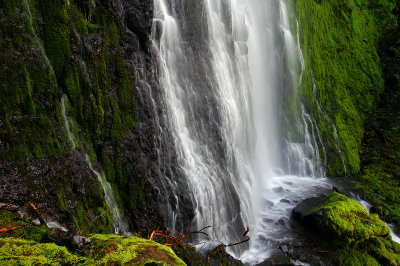
Finally the famous & elusive Lancaster falls of which you can only see the Lower 20'! I've read a few reports of a scramble trial up past this first 20' & I've seen great photos posted by Zach & others but I couldn't seem to see any obvious scramble trail. Can someone give me a few pointers, it it just to the West up a narrow gap in the rock wall?

Image

We came back the top way and were treated to a flyby of 4 big helicopters as we sat on the view point just past the Starvation Ridge Cutoff trail.

Image

Were we back at the car before 12:00 & since we had enjoyed some great views of Wind Mountain we decided to head over there for the afternoon. The Wind Mountain Field Guide does a good job of telling you where the trailhead is. The only thing I would add is if you are in a low clearance car stop in the open area where the pavement ends and walk the last 10th of a mile or so to the trailhead.
The trail is in great shape, & seemingly popular we past 4 other groups on the trail. This would be a great hike for your visiting non hiking out of town friends, only 1 mile long & a 1000 feet up to great views and some old Native American History.

Image

We were careful not to intrude on the old Indian Terraces but I was able to grab this photo from the side.

Image

A great little hike - 20 minutes later we were back at the car!

As always a few more photos here
hiking log & photos.
Ad monte summa aut mors

User avatar
anna in boots
Posts: 2122
Joined: May 28th, 2008, 10:02 pm
Location: In the moment

Re: Lower Starvation Loop & Wind Mountain - 11/14/09

Post by anna in boots » November 15th, 2009, 7:28 pm

Guy wrote:We came back the top way and were treated to a flyby of 4 big helicopters
Guy, yosemite hiker and I saw those choppers, too, on our way out to Tom McCall. Sikorsky's? Definitely military and moving slow. Very cool.

anna in boots
Current trip reports at All Thoughts Work™ Outdoors
http://allthoughtsworkoutdoors.wordpress.com/

User avatar
greglief
Posts: 640
Joined: May 28th, 2008, 10:03 pm
Location: Northern and Western Hemispheres
Contact:

Re: Lower Starvation Loop & Wind Mountain - 11/14/09

Post by greglief » November 16th, 2009, 2:18 pm

Hi!

In response to your question about scrambling up to the higher portion of Lancaster Falls, Tom, Jamie, and I did that last year. If I recall correctly, we trudged up the hill starting slightly before (east of) the lower tier. It is demanding, but doable. If you are interested, you can see my photos here. Here is one of them:

Image
Greg Lief
OregonWildflowers.org - locations, trip reports, user forum, et cetera
Greg's Back

User avatar
Splintercat
Posts: 8334
Joined: May 28th, 2008, 10:03 pm
Location: Portland
Contact:

Re: Lower Starvation Loop & Wind Mountain - 11/14/09

Post by Splintercat » November 16th, 2009, 4:07 pm

That's about right, Greg -- basically, we headed up the hill about 100 feet east of the lower tier, working our up the slope (from tree to tree) until a shallow ravine became apparent east of the stream, separate from the falls by a rocky ridge. As you reach the top of the slope, the brushiest part was traversing across the ravine to the ridge, where the upper tier comes into view. BTW, I looked hard for poison oak, and only saw a very small amount at the top of the slope, near the falls.

Tom

User avatar
Guy
Posts: 3333
Joined: May 10th, 2009, 4:42 pm
Location: The Foothills of Mt Hood
Contact:

Re: Lower Starvation Loop & Wind Mountain - 11/14/09

Post by Guy » November 16th, 2009, 6:54 pm

Thanks guys, something to check out on my next trip up there!
hiking log & photos.
Ad monte summa aut mors

fallsfreak
Posts: 13
Joined: May 27th, 2009, 6:54 pm

Re: Lower Starvation Loop & Wind Mountain - 11/14/09

Post by fallsfreak » November 24th, 2009, 12:09 pm

"Warren Creek Falls ceased to flow in 1938 when someone decided that Warren Creek was causing too much damage to the Old Columbia Highway. They blasted a tunnel through rock to divert the creek with the result that Warren Falls dies & Hole in the Wall Falls was born. No if you walk up the dry creek bed from Hole in the Wall falls you arrive at this dry waterfall."
Is the dry creek bed to Warren Falls west of Hole-in-the-Wall Falls? Do you walk along the rocky area west of the falls at the fork of the trail back to the parking lot and that one rocky area?
Interesting picture of the dry waterfall.

User avatar
Guy
Posts: 3333
Joined: May 10th, 2009, 4:42 pm
Location: The Foothills of Mt Hood
Contact:

Re: Lower Starvation Loop & Wind Mountain - 11/14/09

Post by Guy » November 24th, 2009, 12:15 pm

fallsfreak wrote:Is the dry creek bed to Warren Falls west of Hole-in-the-Wall Falls? Do you walk along the rocky area west of the falls, instead of going back to the trail?
Interesting picture of the dry waterfall.
No, as you approach Hole in the Wall Falls & see it in front of you you will cross the dry creek bed. Turn left here and follow the creek bed up to the dry falls. (So it's just East of Hole in the Wall Falls).

Cheers
hiking log & photos.
Ad monte summa aut mors

Post Reply