Oregon Caves' New Backcountry 22-Nov-2015

This forum is used to share your experiences out on the trails.
User avatar
VanMarmot
Posts: 1924
Joined: May 28th, 2008, 10:03 pm
Contact:

Oregon Caves' New Backcountry 22-Nov-2015

Post by VanMarmot » November 23rd, 2015, 8:14 am

Late last year, the original 488 acre Oregon Caves National Monument was expanded by about 4,000 acres (becoming a National Monument and Preserve in the process) to better protect the watersheds that feed the underground river in the cave complex. A preserve of this type allows for the continuation of hunting, which is not allowed inside the smaller monument boundary.

Image

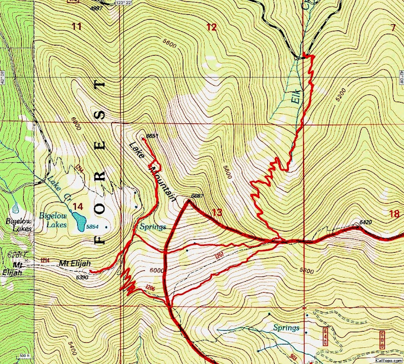
As a result of this expansion, the monument/preserve boundary has been pushed to the tops of the surrounding ridges and now includes the Bigelow Lakes, Mt. Elijah (both of them), and Lake Mtn.

Image

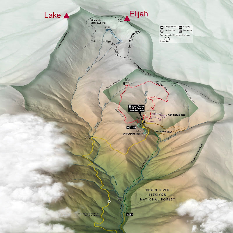
Last February, we had explored this new part of the monument by hiking in from the E via the Sturgis Fk TH (Sturgis Fk TR). While you can also hike into this area from the visitor center to the W, doing so involves a long drive around the mountains to Cave Junction and then up to the caves. A little hiking research found that a hike in from the W was possible - with much less driving - by using the more readily accessible Elk Ck trail (USFS #1230). So the plan was to use this trail to visit Mt. Elijah (again), checkout the old lookout site atop Lake Mtn, and hike another short stretch of the Boundary Trail (USFS #1207). Unfortunately, the LovedOne's knee was acting up again, so this was a solo hike ( :( ).

There was actually a sign at the TH (!) and the trail itself was in pretty good condition.

Image

It climbed steadily, but relentlessly, toward the divide, passing Healy Spring - a local favorite not shown on most maps - enroute. Even late in the season and after 2+ years of drought, this spring was still producing enough water to fill a water bottle in short order.

Image Image

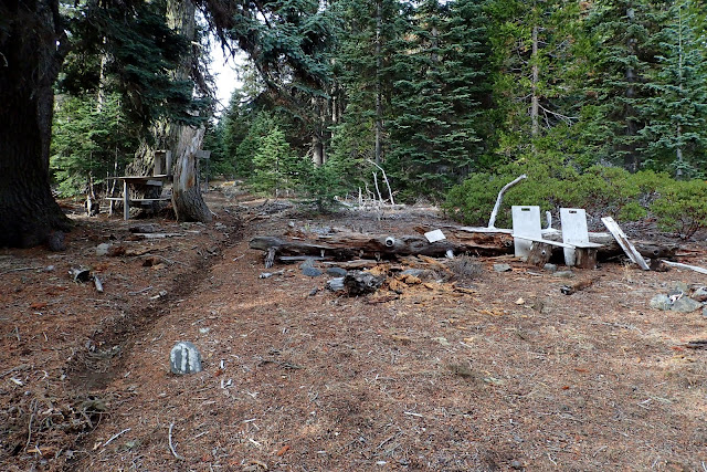
Up on the divide, I came to Sparlin Camp (an old hunting camp used for generations by locals) at the intersection of the Elk Ck trail, the Boundary Trail, and a shortcut trail to Mt. Elijah and the Bigelow Lakes (this is the "motorcycle route" shown for Hike #70 in Sullivan's Southern Oregon guide; but not shown on most other maps).

Image

I took the shortcut through the camp,

Image

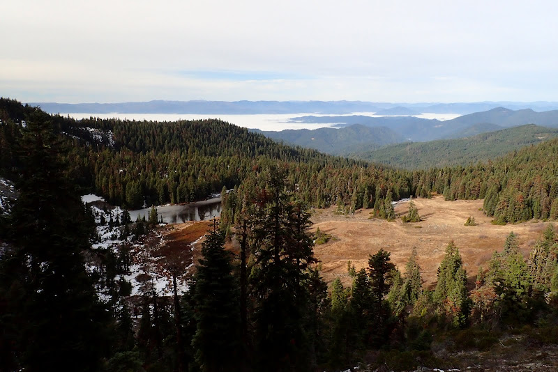
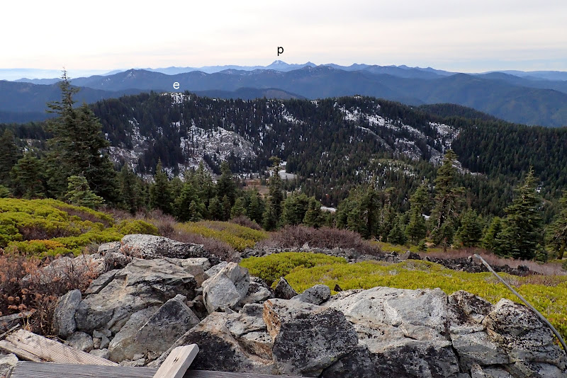
up across one of the large meadows that dot this range - with a view of Preston Peak (p) - the high point in the Siskiyou Wilderness (X) - in the distance,

Image

to the saddle between Elijah and Lake, for a view down the Bigelow Lakes basin toward the Oregon Caves.

Image

I collect old hiking guides and one of these, the Lowe's 1969 guide to hikes in Oregon, tipped me to the former LO site atop Lake Mtn (LO).

Image

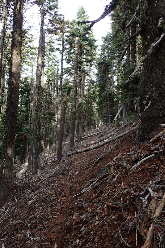
The LO blew down in 1953 but the Lowe's reported that the trail from the saddle to the LO was still mostly intact as of 1969. I was pleased to find that this is still the case - first a pretty good trail to within about 0.25 mi of the summit,

Image

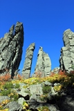
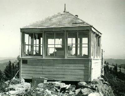
then a brief bushwhack up to and along the rocky ridge to the LO site, which looked like this back in the day,

Image

but has come to this. :(

Image

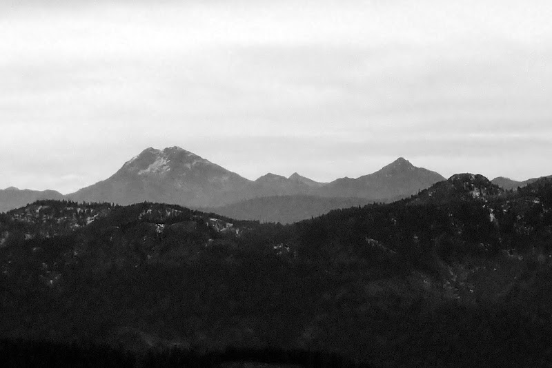
But the view - be still my beating heart! Even with a cloud deck, I had a full 360, with Elijah (e) below and Preston (p) beyond,

Image

Shasta to the SE,

Image

and Preston to the S (OK, these are "art shots").

Image

It was windy and "crisp" on Lake's summit, so I scurried back to the saddle and up to Elijah for a quick lunch, with a view of Lake Mtn in the background.

Image

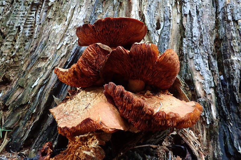
Then, to make a quasi-loop, I descended the #1206 trail (officially the Mt Elijah trail (USFS)) back to the Boundary Trail (#1207), took that back to Sparlin Camp, and descended the Elk Ck trail to the TH - passing an unusal species of soft tree fungus along the way.

Image

A short (8.7 mi, 2200' EG) but interesting hike that let me explore some unmapped local features and some of the history of this newest piece of the Oregon Caves monument. :D

Image
Last edited by VanMarmot on November 24th, 2015, 10:00 am, edited 1 time in total.

User avatar
BurnsideBob
Posts: 538
Joined: May 6th, 2014, 3:15 pm
Location: Mount Angel, Oregon

Re: Oregon Caves' New Backcountry 22-Nov-2015

Post by BurnsideBob » November 24th, 2015, 8:35 am

Another beautifully illustrated trip report that fills in a blank spot on the map.

Thanks for sharing!
I keep making protein shakes but they always turn out like margaritas.

User avatar
VanMarmot
Posts: 1924
Joined: May 28th, 2008, 10:03 pm
Contact:

Re: Oregon Caves' New Backcountry 22-Nov-2015

Post by VanMarmot » November 24th, 2015, 8:46 am

BurnsideBob wrote:Another beautifully illustrated trip report that fills in a blank spot on the map.

Thanks for sharing!
Thanks! Just doing what I can to lure folks out of the Gorge and down here to the uncrowded trails of the State of Jefferson!

User avatar
drm
Posts: 6152
Joined: May 28th, 2008, 10:03 pm
Location: The Dalles, OR
Contact:

Re: Oregon Caves' New Backcountry 22-Nov-2015

Post by drm » November 24th, 2015, 9:19 am

Shasta is NE of Lake Mtn?

I was at the caves last year when the addition was expected. Would be good to add a camp at one of the lakes to a visit to the caves.

User avatar
VanMarmot
Posts: 1924
Joined: May 28th, 2008, 10:03 pm
Contact:

Re: Oregon Caves' New Backcountry 22-Nov-2015

Post by VanMarmot » November 24th, 2015, 10:03 am

drm wrote:Shasta is NE of Lake Mtn?

I was at the caves last year when the addition was expected. Would be good to add a camp at one of the lakes to a visit to the caves.
Right - typo - my bad - Shasta is SE, not NE. :oops:

There is a drive-in USFS campsite near the monument but it's expected to be closed until they can remove some rotted trees. When we hiked around the lakes, we saw several decent campsites. So if you're willing to hike up there, you could have a pretty nice lake-side camping experience.

User avatar
bobcat
Posts: 2768
Joined: August 1st, 2011, 7:51 am
Location: SW Portland

Re: Oregon Caves' New Backcountry 22-Nov-2015

Post by bobcat » November 24th, 2015, 4:05 pm

Great report on the trails leading to the new addition. Thanks also for the information on the closer trailhead. I have no love for that road up to the Caves, winding around and following RVs, and I would never recommend it just for a day hike.

User avatar
VanMarmot
Posts: 1924
Joined: May 28th, 2008, 10:03 pm
Contact:

Re: Oregon Caves' New Backcountry 22-Nov-2015

Post by VanMarmot » November 25th, 2015, 7:53 am

bobcat wrote:Great report on the trails leading to the new addition. Thanks also for the information on the closer trailhead. I have no love for that road up to the Caves, winding around and following RVs, and I would never recommend it just for a day hike.
Here's how to get to this new part of the monument without having to battle RVs:

From Grants Pass, take Hwy 238 south toward Jacksonville. At Provolt, turn south (right) on to the Williams Highway and follow that through the very small hamlet of Williams. The road name changes to Cedar Flat just past Williams and in 3 miles you come to Cave Camp Road. Turn south (left) on to Cave Camp and follow it for 6.7 mi to end of pavement (where it becomes FR 4611), bear right at 7.5 mi, and at 10.4 mi turn left on to FR 079 for 1.6 mi to the #1230 TH on left. Or you can keep going up FR 079 for a short distance to the Bigelow Lakes TH. The Bigelow Lakes are home to more than 120 plant species, including a vast array of wildflowers, a mere 150 feet from the shoreline.

User avatar
derwoodynck
Posts: 286
Joined: April 21st, 2013, 2:26 pm
Contact:

Re: Oregon Caves' New Backcountry 22-Nov-2015

Post by derwoodynck » November 25th, 2015, 7:01 pm

VanMarmot wrote:
BurnsideBob wrote:Another beautifully illustrated trip report that fills in a blank spot on the map.

Thanks for sharing!
Thanks! Just doing what I can to lure folks out of the Gorge and down here to the uncrowded trails of the State of Jefferson!

Keep those reports coming. We really enjoyed our time down in that area this year.

User avatar
VanMarmot
Posts: 1924
Joined: May 28th, 2008, 10:03 pm
Contact:

Re: Oregon Caves' New Backcountry 22-Nov-2015

Post by VanMarmot » November 26th, 2015, 11:51 am

derwoodynck wrote:

Keep those reports coming. We really enjoyed our time down in that area this year.
Good to hear that! I was a little worried that the lower part of the Butte Fork trail might have been a little off-putting as it gets limited use and maintenance. That said, there are plenty of other hikes down here on OK to great trails that never seem crowded... :)

User avatar
Splintercat
Posts: 8333
Joined: May 28th, 2008, 10:03 pm
Location: Portland
Contact:

Re: Oregon Caves' New Backcountry 22-Nov-2015

Post by Splintercat » November 26th, 2015, 3:53 pm

Thanks, Bruce! Ditto for your work on the Field Guide, too - much appreciated! :)

Question on the additions: are they reasonably intact, or had USFS logging already pushed into this watershed?

Tom

Post Reply