Last summer’s
Pablo report on this ridge reminded me that I have been wanting to explore the nether reaches of Barlow Ridge: all the maps and the USFS have the #670 trail as a full-blown legitimate track between Barlow Butte and Klinger’s Camp.
This was also a lesson in pioneer history as I returned along the Barlow Road. My references are mostly gleaned from the application to put the Barlow Road on the
National Register of Historic Places.
Everything was socked in as I began the hike from Barlow Pass in a thick, damp cloud. Going straight down from the picnic table there, rather than down FR 3530, takes you on the old wagon route, which then crosses the road and drops to the head of Barlow Creek. The small meadow at the junction with the Barlow Creek Trail was the site of an excavation in 1976 during which a number of Oregon Trail artifacts were found. Based on this, some think the meadow was the site of Fort Deposit, mentioned in trail diaries, where a rough cabin once stood and where late-arriving emigrants, wanting to travel light over the passes, left possessions and wagons for a late spring retrieval.
 Viewed 4821 times")
 Viewed 4821 times")
I hiked up Barlow Butte. There were still no views, so I continued down along the open ridge crest on the 670 trail. My first stop was Lambert Rock, where I scrambled to the top. The clouds were beginning to lift by that time and I began to get some vistas, including freshly dusted Hood fading in and out of the cloud cover. Farther south on the ridge, I made for a higher pyramidal formation, now christened Barlow Pyramid.
Before I got back up to the ridge, however, I found a flagged trail peeling off to the left. Seventy-five yards from the junction, another trail headed north, perhaps to one of the forest roads that run along Barlow’s east side. I continued along the flagged trail, which was not blazed but in decent shape. This took me down two soggy meadows obviously much frequented by elk and eventually to a short spur road off of FR 3560. A campsite at the end of the road had been recently used, probably by hunters.
 Viewed 4821 times")
 Viewed 4821 times")
I returned to the 670 trail and hiked up to the ridge line, whence I made a short bushwhack and scramble to the top of Barlow Pyramid. The clouds had lifted somewhat and the meadows on Barlow’s steep west slope were glowing. I then kept going along the 670 trail, now clearly little used but still fairly obvious. The trail took me to the high point on the ridge, at 5,170 feet, which offered a partial view back to Hood and a sweeping vista east to the Lookout Mountain-Badger Butte ridge. From there, the trail kept close to the crest, passing through a couple more rocky meadows. From the last of these, the path veered to the west among some impressive old growth Douglas-fir and noble fir. Crossing the top of a shallow gully, the trail picked up a level ridgeline, but soon enough began to drop steeply. By this time, I was navigating by trail markers left decades before: double blazes, red paint spots, and white plastic diamonds on trees. As the trail descended steeply down the nose of this ridge, the diamond markers became my beacons, but soon I lost even these. At some point, I took it into my head to follow a fairly well-defined trail heading west on the level. This carried quite a way along the hillside, but ended at a spring, and I realized the local elk had led me astray. I dropped the short distance from here down to FR 3530 (Barlow Road) and found myself perhaps half a mile west of Klinger’s Camp.
 Viewed 4821 times")
 Viewed 4821 times")
 Viewed 4821 times")
 Viewed 4821 times")
 Viewed 4821 times")
I walked down the road to Klinger’s Camp, just an open spot off the road with a couple of fire circles. Just to the west of this area is another exit off the road which is blocked by branches. This is the lower Barlow Trailhead: the sign is still there and red paint leads you up the ridge.
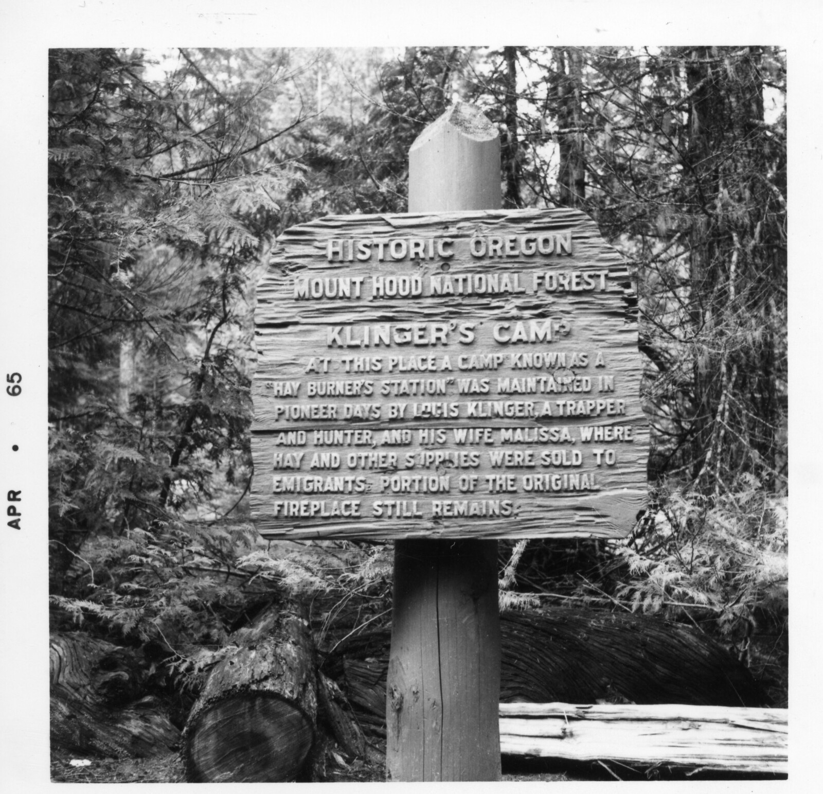
It should be noted that Klinger’s Camp has no documented connection with the Oregon Trail. The association might have begun with a large interpretive sign put up there (the post remains), perhaps by the CCC, in the 1930s. The sign said:
Historic Oregon/ Mount Hood National Forest/ Klinger’s Camp/ At this place a camp known as a/ 'Hay Burner's Station’ was maintained in/ pioneer days by Louis Klinger, a trapper/ and hunter and his wife Melissa, where/ hay and other supplies were sold to/ emigrants a portion of the original/ fireplace still remains
Actually, nothing remains of the fireplace. Also, Louis Klinger homesteaded at Eightmile Creek, not here. This place was the site of a trapper’s cabin constructed by one Joe Douglas and the Klingers probably passed through here on occasion. The CCC sign seems to have disappeared or been taken down some time in the 1990s.
My original intention had been to return via the White River Trail to the Mineral Jane Ski Trail, but I had frittered much time on the ridge and, also dreading all the blowdown on the White River, another USFS trail which is really a non-trail, I hiked back along the Barlow Road.
This is one of the more pleasant road walks one could imagine. From Klinger’s Camp at least half the way to Devil’s Half-Acre there is towering old growth and the road is narrow and rutted, more like a wide trail. A couple of motorcycles and hunters rigs passed me, rumbling along very slowly, but generally I was alone with the conifers. The wagon route deviates from the forest road at one point, and I paused for a serious episode of rut watching. Then I headed up past the Grindstone Campground to cross Barlow Creek and arrive at Devil’s Half-Acre.
 Viewed 4821 times")
 Viewed 4821 times")
 Viewed 4821 times")
 Viewed 4821 times")
This broad meadow also has an apocryphal association with the Oregon Trail. It didn’t exist when Barlow built his road and the first emigrants came through. In fact, the pioneers bewailed the lack of grazing for their stock until they reached Summit Meadows, near Trillium Lake. Over the years, however, emigrants set fires to burn brush and downed trees. Some of these went out of control, and by the 1880s, the area was a swath of blackened snags that eventually morphed into a wide, grassy expanse. From here, it was a little over a mile up the slope to the pass.
 Viewed 4821 times")
Note: The two side trails I encountered below the Barlow Pyramid seem offer opportunities for loops, a short one back to the Mineral Jane Ski trail and a longer one with a ¼ mile bushwhack from the end of the 240 spur down to the White River Trail at the point of Barlow’s east ridge. The Barlow Butte Trail may be better navigated coming up from Klinger’s Camp – but it’s a broad ridge at the bottom, and the confusion of elk and deer trails can put you off.