First off, I want to say thanks to everyone on this forum. I come here to be inspired and to be amazed at some of the things that you folks do. I would have never thought of this particular loop on my own. In fact, LNT, not cutting switchbacks, not trampling meadows was so deeply ingrained in me that 2 years ago the thought of going off trail was, well, unthinkable and uncomfortable. All of those things are still part of me but I've gotten more comfortable in stepping off that 3-ft wide tread...
This loop has been on my to-do list all summer. In fact, I had it on the calendar twice before but things didn't work out either time. Well...the 3rd time was the charm. And what a charm it was. This is a spectacular loop that takes a little bit of effort...okay a lot of effort...it clocks in mileage-wise and elevation gain about what a summit of South Sister is. My only regret is that I had to leave my son Ben at home (sprained foot doing parkour ). The flip side to that is that I was able to linger in some of spots waiting for the clouds to clear to get some photos without feeling guilty.
There have been several reports this year of the loop but the general gist is:
1. Start at Timberline Lodge
2. Head clockwise on the Timberline Trail
3. Descend into Zigzag Canyon and cross the Zigzag River
4. Turn onto the Paradise Park Loop trail and ascend up to Paradise Park
5. Go to Split Rock on the far side of Paradise Park
6. Now go up to what other's have called Paradise Top following a well-worn boot trail that's not on the maps.
7. At Paradise Top, the trail ends so you pick your way up over the high-point of Mississippi Head. This is all loose ash and rock and is where the real fun starts
8. From the high-point of MH, descend 300 feet to see some of the debris from the 1949 B-26 crash (http://guy.smugmug.com/photos/i-gBx7SF5 ... SF5-X3.jpg) and check out the the jump at the end of Mississippi Head that was presumable made for this: https://www.youtube.com/watch?v=yRZd1Tq ... e=youtu.be
10. Work up another 1000' to get over the top of Zigzag Canyon. Once up here you can see the Palmer Lift. This is the toughest part of the loop...
11. Work your way over/down to Silcox Hut
12. Close the loop by descending to Timberline Lodge.
http://gpsfly.org/gps_map.php?gps_id=3652&w=645&h=440
There weren't many folks out on the trail on Saturday. I probably ran across a dozen or so folks all day. Ran into two SOBO thru-hikers. They flopped at Crater Lake because they got a late start (middle of May). Trail names of Tasty and Storybook. They were moving up out of Zigzag Canyon. 2,000 miles of hiking puts bands of steel in your legs I guess.
Ran into two gentleman taking a break at the Zigzag River. If I heard them right, they started at Timberline and were headed over to Eden Park and then coming back. Sounded like a long day to me. Were any of you PH's them?
After about half-way up to Paradise Top, I didn't see another soul until I made it back down to Silcox Hut where I ran into some snowboarders coming off Palmer. They all piled into a couple of vehicles parked at the hut and drove down. Didn't seem quite right to me...
Excuse the number of photos. I couldn't get enough of the mountain. I probably took 350 photos during the day...
Click on any photo to see it in the gallery. All of these (and many more ) can be seen here: http://www.mikejulianaphotography.com/F ... sippi-Head
Opening Shot from Timberline Lodge
Looking south to Skibowl and Tom, Dick, and Harry Mountain where we were two weeks ago...
Zigzag Canyon overlook
Close-up view of Mississippi Head
Zigzag River Crossing...easy two rock hop at this time of the year
Lost Creek. Took the opportunity to filter some water here.
The clouds came and went all day. Sometimes the top was cloaked in clouds and at other times, it was crystal clear. It was magic watching the clouds swirl every which way.
A little bit of fall color creeping into the scene
The view from just before Split Rock
...and Split Rock and it's companion tree. How did Split Rock get here?
William P. Hardesty
April 5, 1865 - Aug. 12, 1944
He devoted his life to his work and to the "out-of-doors" and the friends he made there
Charles H. Sholes
Jan. 10, 1853 - May 13, 1947
He pioneered in making known to the world the beauty and grandeur of these mountains
The little knob middle right is the highest part of MH. That's the next goal...
Profile view of MH looking it at from the west...from here the journey goes up
Looking back down on Split Rock which is just about dead center in this photo
The top of the one of the arms of Sandy Canyon on the left. From here, it's along the ridge and then up the loose scree at the far end.
Sandy Canyon and the source of one of the forks of the Sandy. Does this fork have a name? Don't see anything on any of my maps.
Love how this side of Mt Hood looks like the back of a stegosaurus...
Closer look at the waterfalls. A month ago in another post there was still snow between the two.
Not even going to venture to guess if that is Yocum Ridge over there. Unfortunately, I didn't have anyone to debate this one with . Lost Lake out in the distance?
Need to somehow to get up to that knob on the right. It's just slogging up through the loose stuff. I do have to say that scrambling up and down the banks of the Deschutes in waders is good practice for this... This is where having a GPS track can really help keep you honest. I used Backcountry Nav on my phone for the 1st time and came away impressed. I didn't use it to track my course but used it to pinpoint my location. I used my bike GPS for tracks...
I finally made it to the high-point of Mississippi Head... ...looking down at the Zigzag Canyon and river.
Looking down to the point of the V where the debris field and jump are located
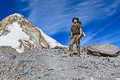
Sorry for the selfie...
The now famous ski ramp...
About as close as I dared to get to the edge looking straight down to the ZigZag. Yup..it's a long ways down.
From here, it's another 1,000 foot slog up the loose stuff to get around the top of Zigzag Canyon but the views as you get over the top are worth it!
Illumination Rock on the left
Closer look at the crater and Crater Rock. What's that black looking stick that appears to have slid down in the center from the left?
Meet Illumination Rock
Wow...
and finally the Palmer Ski Lift peeks over the horizon...
Middle Part of the Palmer Lift. My kids have been up here many times during the some for ski camps but I had never been up here. Can you imagine riding the lift on a clear summer day of training and seeing the view of the top of the mountain every loop. Would be cool...
On my way down following the Palmer lift towers down, I ran across this. As a ski racing family, I hate seeing these. Here's the story: http://www.mthood.com/kees.htm
I have to think Timberline maintains this narrow patch of snow so they can get grooming equipment up to Palmer
Silcox Hut and Mt Hood
What is this? It's located above Timberline Lodge
And back to the lodge...
11.2 Miles and 4200' of EG. One peanut butter sandwich...one Lindt Dark Chocolate and Salt Bar (dark choc turns grainy/waxy when it gets cold. Not nearly as enjoyable when it's a little warmer), a pack of ritz crackers, a snickers bar, a zbar, plus about 5 liters of water. Oh yea and that Brownie Sundae at DQ on the way home... pretty good day...
Timberline Lodge -> Mississippi Head Loop (9/27/2014)
Last edited by mjuliana on September 30th, 2014, 9:15 am, edited 1 time in total.
Thanks,
Mike J
Mike J
- adamschneider
- Posts: 3716
- Joined: May 28th, 2008, 10:02 pm
- Location: SE Portland
- Contact:
Re: Timberline Lodge -> Mississippi Head Loop (9/27/2014)
If you're feeling lazy, you can skip #5 and #8. It's possible to ascend from Paradise Park right along the west side of Zigzag Canyon (without having to go all the way over to Split Rock).mjuliana wrote:There have been several reports this year of the loop but the general gist is:
1. Start at Timberline Lodge
2. Head clockwise on the Timberline Trail
3. Descend into Zigzag Canyon and cross the Zigzag River
4. Turn onto the Paradise Park Loop trail and ascend up to Paradise Park
5. Go to Split Rock on the far side of Paradise Park
6. Now go up to what other's have called Paradise Top following a well-worn boot trail that's not on the maps.
7. At Paradise Top, the trail ends so you pick your way up over the high-point of Mississippi Head. This is all loose ash and rock and is where the real fun starts
8. From the high-point of MH, descend 300 feet to see some of the debris from the 1949 B-26 crash
10. Work up another 1000' to get over the top of Zigzag Canyon. Once up here you can see the Palmer Lift. This is the toughest part of the loop...
11. Work your way over/down to Silcox Hut
12. Close the loop by descending to Timberline Lodge.
Re: Timberline Lodge -> Mississippi Head Loop (9/27/2014)
Nice day! Sure nice to see all that smoke from 36 Pit has dissipated, compared to just a week ago. Loved that ground cloud in your first Split Rock shot. And the view over the cliffs sent my vertigo into deep queasy mode!
Wish I had answers to some of your questions. I've pondered most of the same ones, myself. That round tank looks like it might be for water storage? And that thin strip of snow actually shows up on USGS maps! So while Timberline definitely uses it as a sno-cat route, I think it is somewhat naturally persistent. (Less so with each passing year, it seems.)
Karl
Back on the trail, again...
Re: Timberline Lodge -> Mississippi Head Loop (9/27/2014)
Nice report and great photos! I was up there the weekend before last but turned back just below the Head because a howling east wind was constantly churning up dust devils blowing sand in my face. Great views of the Lot 36 Fire, though.
- retired jerry
- Posts: 14417
- Joined: May 28th, 2008, 10:03 pm
Re: Timberline Lodge -> Mississippi Head Loop (9/27/2014)
I've done most of that, I have to do the full loop sometime
nice pics
Easier to just continue up end of Paradise Park Trail rather than go over to Split Rock. Saves hiking across Paradise Park (0.5 miles) and saves a little walking back on steep slopes above
nice pics
Easier to just continue up end of Paradise Park Trail rather than go over to Split Rock. Saves hiking across Paradise Park (0.5 miles) and saves a little walking back on steep slopes above
Re: Timberline Lodge -> Mississippi Head Loop (9/27/2014)
I pulled this from one of your older TR's. I think this is what you are describing?adamschneider wrote: If you're feeling lazy, you can skip #5 and #8. It's possible to ascend from Paradise Park right along the west side of Zigzag Canyon (without having to go all the way over to Split Rock).
My wife won't even look at that photokepPNW wrote:the view over the cliffs sent my vertigo into deep queasy mode!
That's what it looked like to me as well...Google wasn't any help though.kepPNW wrote:That round tank looks like it might be for water storage?
I know what you are saying about the wind. Most of the time it was fairly calm but when the clouds rolled in, it seemed to pick up to blow the hat of your head levels...made it real cold fast...bobcat wrote:Nice report and great photos! I was up there the weekend before last but turned back just below the Head because a howling east wind was constantly churning up dust devils blowing sand in my face.
Next time for me, I'd like to venture up to Illumination Rock. When should we go?retired jerry wrote:I've done most of that, I have to do the full loop sometime
Thanks,
Mike J
Mike J
- adamschneider
- Posts: 3716
- Joined: May 28th, 2008, 10:02 pm
- Location: SE Portland
- Contact:
Re: Timberline Lodge -> Mississippi Head Loop (9/27/2014)
Yes, exactly. As Jerry said, it's just the above-timberline continuation of the Paradise Park Trail. That loop was less than 10 miles.mjuliana wrote:I pulled this from one of your older TR's. I think this is what you are describing?adamschneider wrote: If you're feeling lazy, you can skip #5 and #8. It's possible to ascend from Paradise Park right along the west side of Zigzag Canyon (without having to go all the way over to Split Rock).
- Born2BBrad
- Posts: 1086
- Joined: May 1st, 2011, 7:26 pm
- Location: The Dalles
Re: Timberline Lodge -> Mississippi Head Loop (9/27/2014)
Even though I was just there, I enjoyed seeing it again through someone else's eyes. It's a worthy trip that's not too difficult.
I'm not sure how a feel about memorials to people out in the woods. If everybody had one, there would be memorials everywhere.
Make now always the most precious time. Now will never come again.
- Jean Luc Picard
Link to GPX tracks
Link to Trip Reports
- Jean Luc Picard
Link to GPX tracks
Link to Trip Reports
- Eric Peterson
- Posts: 4097
- Joined: May 11th, 2009, 5:39 am
- Location: Oregon
- Contact:
Re: Timberline Lodge -> Mississippi Head Loop (9/27/2014)
Hey Adam, do you have a track for the way you go?
Thanks
Thanks