Olallie Area: Gibson and Breitenbush Lakes; Olallie Butte

This forum is used to share your experiences out on the trails.
User avatar
bobcat
Posts: 2768
Joined: August 1st, 2011, 7:51 am
Location: SW Portland

Olallie Area: Gibson and Breitenbush Lakes; Olallie Butte

Post by bobcat » September 11th, 2014, 4:45 pm

My wife and I spent a couple of nights camping at Olallie Lake last week. The weather was balmy, the huckleberries prolific – especially at the Peninsula, but there was a fairly stiff easterly blowing. In addition to berry picking, we went canoeing on the lake and did a short hike together; the next day, I went up Olallie Butte in the morning before we had to haul it back to Portland.
Guard station, Olallie Lake.jpg
Garter snake, Olallie Lake.jpg
Both hikes led onto the Warm Springs Reservation, so I will also report on the status of hiking on Warm Springs territory in the Olallie area. This is the area of the McQuinn Strip, the subject of a century-old surveying mistake concerning land which reverted to the tribes in 1972, but was previously managed by the Forest Service.

For the first hike, we drove up to Horseshoe Lake and did a lollipop loop (6.0 miles round trip) to Breitenbush Lake via Gibson Lake and the PCT. The last mile to Horseshoe Lake on FR 4220 (Skyline Road) might disembowel cars with low clearance, but our Honda CR-V was fine. The Horseshoe Saddle Trail leads up to the ridge to connect with the PCT. We passed a sign memorializing “Rondy” Rondthaler, a former trails supervisor for the Mt. Hood National Forest, who was known for resurrecting abandoned trails, an ethic that seems to have disappeared with all the budget cuts.
Horseshoe Lake, Olallie Lake Scenic Area.jpg
Tarn reflection, Horseshoe Lake, Olallie Lake Scenic Area.jpg
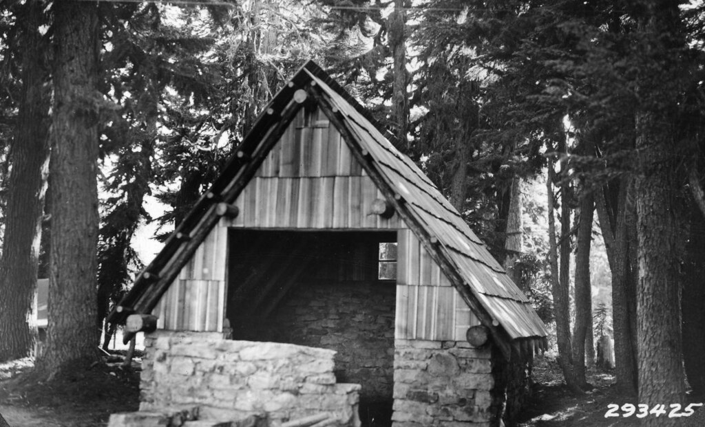
From the PCT, we connected with the Gibson Lake Trail which heads onto Warm Springs land. Gibson Lake is one of the highest lakes in the Olallie area and the trail seems to be well-maintained and has a new sign on the Warm Springs end. There are great viewpoints heading up to the lake looking north past Mt. Hood. Eventually, the trail drops down to the Skyline Road and you are immediately greeted by CLOSED AREA signs on the east side of the road. This means you cannot get to Breitenbush Lake at this point nor do the trail loop around the lake. We respected the signs and hiked down the road to the Breitenbush Lake Campground, which is operated by Warm Springs. The only place outsiders can legitimately visit the lake shore here is at the campground. There’s an historic shelter here and meadows and ponds back of the lake (also off-limits, though). Campbell Butte rears above.
Olallie and Monon Lakes from the Gibson Lake Trail.jpg
Gibson Lake, Gibson Lake Trail.jpg
Sign at junction with FR 4220, Gibson Lake Trail.jpg
No trespassing sign, Breitenbush Lake.jpg
Campbell Butte and Breitenbush Lake.jpg
Historic shelter, Breitenbush Lake.jpg
Old water fountain and information kiosk, Breitenbush Lake.jpg
We walked a little farther down the Skyline Road and picked up the PCT, now back on public land, which ascends through a burn and then passes two unnamed lakes. We crossed a steep talus slope which offered views back to Pyramid Butte, Mount Jefferson and all along the North Fork Breitenbush valley. You could see Battle Ax on the skyline. We then closed the loop and hiked back down the Horseshoe Saddle Trail.
Second high lake, PCT, Olallie Lake Scenic Area.jpg
Pyramid Butte and Mt. Jefferson from the PCT, Olallie Lake Scenic Area.jpg
The next morning, I drove up to the powerline corridor, parked the car, and headed up the Olallie Butte Trail (7.4 miles round trip). The Forest Service has a sign saying you are hiking the trail “at your own risk,” meaning they won’t come and rescue you if you are injured on Warm Springs territory. The forest gets more venerable as you ascend, with some substantial mountain hemlocks interspersed with glades of partridge-foot and paintbrush. Eventually, I came out on a cinder slope dotted with whitebark pine, subalpine fir, and mountain hemlock. Then I switchbacked up to a saddle between the two summit bumps of Olallie Butte, the highest prominence between Mt. Hood and Mt. Jefferson. To the north, there was the stone-walled foundation of the lookout, which has collapsed to one side, the victim of an easterly storm.
USFS warning sign, Olallie Butte.jpg
View to Sisi Butte, Olallie Butte.jpg
Mt. Hood from the Olallie Butte Trail.jpg
The cinder slope and Mt. Hood, Olallie Butte Trail.jpg
Lookout, Olallie Butte.jpg


Circling around the summit area, with the wind blowing so hard that many of my photos turned out fuzzy, I looked down on spectacular volcanic formations on the east and south sides, including a natural arch. On a somewhat hazy summer day, views extended from the Three Sisters to Mt. Rainier, with numerous Olallie Lakes glistening below. I had to find shelter down the west side before I could eat a snack: the gale was stirring up cinders in colorful funnels and I could only stand straight by leaning into it.
Natural arch, Olallie Butte.jpg
Mt. Jefferson, Long and Dark Lakes, Marie Lakes, Monon Lake from Olallie Butte.jpg
Mt. Jefferson, Olallie and Monon Lakes, Olallie Butte.jpg
Olallie and Monon Lakes from Olallie Butte.jpg
Hiking/camping on Warm Springs land contiguous with the Olallie Lake Scenic Area:

Gibson Lake: No camping; no swimming.

Breitenbush Lake: Lake access only at the campground; some campsites off limits; no hiking around the lake; no hiking to Harvey Lake, Kuckup Park, or Shitike Canyon; no swimming; no huckleberry picking; dogs on leash; no dogs swimming in the lake; no wood cutting or gathering; no alcohol.

Long and Dark Lakes: Trail from southeast corner of Olallie Lake maintained by Warm Springs to Dark Lake; Warm Springs fishing permit required; no camping; no swimming.

Olallie Butte: hike at your own risk; no off-trail hiking; no camping.

Brook, Jude and Russ Lakes: no camping; no swimming.

PCT on Warm Springs land: Keep to the trail; no overnight camping except by through-hikers.

Note that no alcohol, even in sealed containers, is permitted on reservation land.

I should note that in the late '80s, I camped at Breitenbush Lake and hiked up to Harvey Lake and the Shitike Canyon overlook. It was legitimate then, but a few years later Warm Springs decided to put in heavy restrictions to the point that they don't even allow non-tribal fishermen up to Harvey Lake even if they have a permit.

User avatar
RobFromRedland
Posts: 1095
Joined: May 28th, 2008, 10:03 pm

Re: Olallie Area: Gibson and Breitenbush Lakes; Olallie Butt

Post by RobFromRedland » September 11th, 2014, 5:30 pm

Great trip report! Love the photos.

Here is what the Lookout looked like in 1963 (looks like it had seen better days even at that point!)
OlallieButteLookout2-1963.jpg
Olallie Butte Lookout in 1963
bobcat wrote:The Horseshoe Saddle Trail leads up to the ridge to connect with the PCT. We passed a sign memorializing “Rondy” Rondthaler, a former trails supervisor for the Mt. Hood National Forest, who was known for resurrecting abandoned trails, an ethic that seems to have disappeared with all the budget cuts.
I've been in touch with Rondy's daughters - I found out about him from some historical research I've been doing at the FS. He truly sounded like a trail guy. On some of his old notes it was interesting to see his comments - He didn't like the Dry Ridge trail, but he had it re-routed to make it a bit more scenic. He tried to resurrect many old abandoned trails. I found his detailed notes about a trail that still lives (although still officially abandoned). He really sounded like a neat guy - I wish I could have met him.

I think it is cool they put up a sign commemorating him.
Life is not a journey to the grave with the intention of arriving safely in a pretty and well-preserved body, but rather to skid in broadside, thoroughly used up, totally worn out, and loudly proclaiming: WOW! What a ride! - Hunter S. Thompson

justpeachy
Posts: 3068
Joined: May 28th, 2008, 10:03 pm
Location: Portland, OR
Contact:

Re: Olallie Area: Gibson and Breitenbush Lakes; Olallie Butt

Post by justpeachy » September 11th, 2014, 6:31 pm

Cool report! I didn't know that shelter at Breitenbush Lake was still there. Here's what it looked like when it was built in 1934. Hasn't changed much!

Image


I was down in the Olallie area last weekend and tried to drive that road to Horseshoe Lake but gave up. My Outback probably could have made it, but I'm overdue for new tires and didn't want to push my luck.

User avatar
kelkev
Posts: 800
Joined: May 28th, 2008, 10:03 pm
Location: McMinnville, OR

Re: Olallie Area: Gibson and Breitenbush Lakes; Olallie Butt

Post by kelkev » September 11th, 2014, 6:58 pm

Excellent trip report. I fished at Breitenbush Lake when I was in high school back in the early 80's, I didn't realize that it wasn't open for fishing anymore. Love that old shelter! A few years ago, my wife and I hiked from Breitenbush PCT trailhead up to Gibson Lake, up Ruddy Hill, then down to the Horseshoe Lake overlook and back on the road to the car. Beautiful country.

That "Closed Area" sign is familiar to me in another place - - on the north side of Candle Creek where it empties into the Metolius River.

Kevin
"Going to the mountains is going home."
— John Muir

User avatar
bobcat
Posts: 2768
Joined: August 1st, 2011, 7:51 am
Location: SW Portland

Re: Olallie Area: Gibson and Breitenbush Lakes; Olallie Butt

Post by bobcat » September 11th, 2014, 7:19 pm

@Rob: Here's a picture of the Rondy Rondthaler sign near the Horseshoe Saddle Trailhead:
Rondy Rondthaler sign, Horseshoe Saddle Trail.jpg
@kelkev: I just edited my post. You can fish at Breitenbush Lake with a tribal permit, but only from the campground area.

Thanks for the great old photos, Rob and justpeachy!

forestkeeper
Posts: 1291
Joined: July 23rd, 2011, 8:31 pm
Location: Canby, Oregon
Contact:

Re: Olallie Area: Gibson and Breitenbush Lakes; Olallie Butt

Post by forestkeeper » September 11th, 2014, 10:31 pm

:D Excellent TR! Beautiful photos. I see that my sign I posted is still up at the Olallie Butte trailhead. Sorry my writing is a little crooked. How was the trail up to the top? I cleared blow downs last summer but haven't been up there this year due to focusing on areas along the Collawash and Clackamas River. If there's still a few blow downs, I'll go up there again.

Thanks.

Will

User avatar
bobcat
Posts: 2768
Joined: August 1st, 2011, 7:51 am
Location: SW Portland

Re: Olallie Area: Gibson and Breitenbush Lakes; Olallie Butt

Post by bobcat » September 12th, 2014, 3:15 pm

@Will: Interesting that you were working on the Olallie Butte Trail. I've always been told it's "unofficial." Do you work all the way up, or just to the Rez boundary?

There are one or two small trees down in the lower (lodgepole) area (This I would have cleared myself if I'd had time); higher up, in the old growth area, there are a couple of large mountain hemlocks down close to each other. There are detours around them, but it'll take a little work to get them off the trail.

forestkeeper
Posts: 1291
Joined: July 23rd, 2011, 8:31 pm
Location: Canby, Oregon
Contact:

Re: Olallie Area: Gibson and Breitenbush Lakes; Olallie Butt

Post by forestkeeper » September 12th, 2014, 6:11 pm

:) Officially, I just clear trail on Federal lands. Unofficially, I do clear trails wherever, being the Warm Springs natives can barely take care of campgrounds on Indian land less alone do trail maintenance. ;)

p11
Posts: 6
Joined: June 2nd, 2010, 7:51 am

Re: Olallie Area: Gibson and Breitenbush Lakes; Olallie Butt

Post by p11 » September 12th, 2014, 6:46 pm

Breitenbush Lake is NOT on any Warm Springs fishing permits.

They took Harvey lake off the permit list about 5 years ago.

https://www.tribalpermit.com/

I have found the closed road signs at the reservation boundary at Horseshoe Lake in years past, typically in August and September at least.

The reservation is holding activities up at the lake, but the campground has been usually open.

The public should have right of passage on the road between Horseshoe and Breitenbush by my reading of the treaty.
Discretion may be the better part of valor in this case.

I think the Forest Service District also has their opinion on the closed road signs when they appear.
The closed area signs West of the road are a different story.

User avatar
bobcat
Posts: 2768
Joined: August 1st, 2011, 7:51 am
Location: SW Portland

Re: Olallie Area: Gibson and Breitenbush Lakes; Olallie Butt

Post by bobcat » September 13th, 2014, 7:30 am

@p11: I've reedited my post; thanks for the clarification. No permits required at Breitenbush (or at Russ, Jude, Brook Lakes) although non-tribal fishermen do fish all of these. So they don't need a permit, or are they flouting Warm Springs regulations? There are no NO FISHING signs posted. That is a little murky to me as the sign at Breitenbush (see #1) implies that fishermen can use non-restricted areas:
Warm Springs restrictions, Breitenbush Lake.jpg
I'm not much of a fisherman, so I'll leave those interested to clarify the whole thing with Warm Springs (Over the years, I've sent a handful of e-mails asking about the trails and they've never responded).

As for Skyline Road on tribal land, it's free for travel by outsiders. I know that the road closed signs sometimes come up between Horseshoe Lake and Breitenbush Lake when there are tribal gatherings (but they were not there last week); we should respect those occasional closures.

I get the feeling that murkiness, i.e. no definitive pronouncements one way or the other, is the preferred state of things in some cases, but if there is abuse by outsiders, Warm Springs certainly has the jurisdiction to clamp down.

Post Reply