Since May I have been doing a hike a month in the monument and I plan to continue until the snows stop me. So I picked a in and out to the summit of Mt. Whittier for August. Not doing Peder's favorite loop allowed me to travel on the fun part of the ridge twice. This is one of the classic hikes in this area if you dont mind a little air beneath your feet I highly recommend it.
I got a later start than I like and left the Norway pass trail head after ten. It was a perfect temperature with light wind and hazy sunshine. I saw some people around Norway pass and that was about it for the day.
I took the Boundary trail five miles to the Whittier ridge junction.
Whittier and the ridge on the right the trail snakes around.
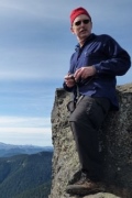
The King of the Northwest standing tall.
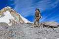
A real climber waiting to laugh at the awkward creature coming his way.
I had to come down Erics Sippy Cup Ledge so I sucked on my Binky and held my breath.
Making progress.
It eases off a bit near the top.
The top.
The little peak right in front is the true summit I believe my perch was fine.
I could have easily followed the ridge to the Lakes trail and looped around.I decided since
Peder patiently waited for me to heal. I could wait for his return (if he comes back) and we can
do it together.
So I retraced my steps.
Back up the Sippy Cup.
And return to the Boundary trail.
A quick stop at Norway pass for a photo and some berries.
The kind of day you dont want to end.
I showed over fourteen miles and over three thousand foot eg I dont think it was that far. Not much commentary necessary for a tr to Whittier .
Peder's favorite Mt Whittier 8/20
The downhill of the mind is harder than the uphill of the body. - Yuichiro Miura
Re: Peder's favorite Mt Whittier 8/20
Very nice. The Whittier Ridge trail is a bit intimidating, but looks worth trying out sometime. I was really taken with the Mt St Helens area this summer and look forward to exploring it more whenever I next make it out to the PNW (alas, I am back in NJ now, and should probably stop lurking the forum because seeing all the TRs just depresses me
- adamschneider
- Posts: 3716
- Joined: May 28th, 2008, 10:02 pm
- Location: SE Portland
- Contact:
Re: Peder's favorite Mt Whittier 8/20
Is it? When I was up there last October, I couldn't tell which was higher. I scrambled out to the little southern pinnacle just in case that was the summit, but it was sketchy as hell and I don't recommend it.Roy wrote:The little peak right in front is the true summit...
Re: Peder's favorite Mt Whittier 8/20
Is the recommended way to do Whittier from the south as you did or from the north? I think it would be easier to be going up during the sketchier parts...
Thanks,
Mike J
Mike J
- adamschneider
- Posts: 3716
- Joined: May 28th, 2008, 10:02 pm
- Location: SE Portland
- Contact:
Re: Peder's favorite Mt Whittier 8/20
The "sketchier parts" have both ups and downs, but mostly they're traverses. The only notable section I remember that might be easier going up rather than down was between the summit and the big pinnacles, and if you wanted to go uphill on that bit, you'd want to go south to north.mjuliana wrote:Is the recommended way to do Whittier from the south as you did or from the north? I think it would be easier to be going up during the sketchier parts...
But overall, I don't think Whittier is nearly as bad as its reputation, especially since the 2011 re-route on the northwest end of the ridge.
Last edited by adamschneider on August 21st, 2014, 3:17 pm, edited 1 time in total.
Re: Peder's favorite Mt Whittier 8/20
Do you know the mile distance for the entire loop utilizing the Lakes Trail??
Thats high on my to-do list.
Thanks
Thats high on my to-do list.
Thanks
- adamschneider
- Posts: 3716
- Joined: May 28th, 2008, 10:02 pm
- Location: SE Portland
- Contact:
Re: Peder's favorite Mt Whittier 8/20
14 or 15 miles. Here's a map from my trip last year: http://adamschneider.net/photos/2013-10-wr/map.htm-Q- wrote:Do you know the mile distance for the entire loop utilizing the Lakes Trail??
Thats high on my to-do list.
Thanks
Re: Peder's favorite Mt Whittier 8/20
Awesome, thanks Adam!!adamschneider wrote:14 or 15 miles. Here's a map from my trip last year: http://adamschneider.net/photos/2013-10-wr/map.htm-Q- wrote:Do you know the mile distance for the entire loop utilizing the Lakes Trail??
Thats high on my to-do list.
Thanks
Re: Peder's favorite Mt Whittier 8/20
I agree but the people that freak out on the Devils Elbow would not do well up there.adamschneider wrote:
But overall, I don't think Whittier is nearly as bad as its reputation
The downhill of the mind is harder than the uphill of the body. - Yuichiro Miura
Re: Peder's favorite Mt Whittier 8/20
When I did Whittier a month ago, my GPS showed the south summit to be, as I recall, 3 feet higher, if it is to be believed. And yes, definitely sketchy, particularly when you consider the exposure!Roy wrote:
The little peak right in front is the true summit...
AdamSchneider wrote:
Is it? When I was up there last October, I couldn't tell which was higher. I scrambled out to the little southern pinnacle just in case that was the summit, but it was sketchy as hell and I don't recommend it.
Kelly
There is no shortcut to anyplace worth going to.
PM me about the soon to be released:
Skamania 231
"How to really get off the beaten path in Skamania County"
There is no shortcut to anyplace worth going to.
PM me about the soon to be released:
Skamania 231
"How to really get off the beaten path in Skamania County"