I had been on a couple shorter backpacking trips with my wife, Tamara. But never any multi-night ones. We were excited to tackle the Timberline Trail. We've read many accounts of the trail and the Eliot Crossing on this site and are very appreciative of all the posters who take the time to share their experiences.
Day 1:We took off on Sunday morning at 10:00am. Our goal was to circumnavigate Mt Hood in the typical time which was 4 days (3 nights). It was a cold, foggy, misty morning. We thought we might be hiking some lonely miles. I’d read about one hiker that said he saw no more than 6 people a day on the trail. That was not the case for us. Day 1, we saw 87 hikers.
We finally got our first peak of the mountain at the ridge over Zig Zag Canyon. The fog was breaking! Zig Zag was running high and fast. We ran into a couple of other hikers, a PCT’er and a nice man that was very familiar with the Timberline Trail. From Zig Zag we connected with the Paradise Trail Loop. This was a beautiful side trip with all of the colorful flowers in bloom and this is also when we finally got some clear shots of Mt Hood. We took a break for lunch.
The route down to the Sandy River was pretty quiet. We got to Sandy and saw what a real river looks like. We were told to expect 4 very difficult river crossings: Sandy, Muddy Fork, Coe, and White. The Sandy was high and running very fast. It was intimidating. The PCT’er was on the other side changing into dry clothes. He hollered over “You will get wet!” Thankfully we spotted some cairns that lead us to a spot up stream a little ways with some logs covering half the river and rocks that we could jump across on the other half. We did get wet crossing the Sandy, but only up to our knees. We also met another couple looking to circumnavigate Mt Hood, too.
From there it was to Ramona Falls. It was pretty crowded so we took a quick picture and kept moving. Our next destination was a camping spot near the Muddy Fork.
After 7.5 hours of hiking. we finally got to our campsite at 5:30. We stopped at a spot about 1/4 mile before the Muddy Fork. This was a nice spot with 3 sites. We were the only ones there. We were feeling pretty good, but we were a little frustrated with our pace. We typically like to knock out the miles quickly. We were not prepared for the rivers, obstacles, and the elevation gains slowing us down so much. But on a more positive note, it was a pleasure slowing down to talk to the other hikers.
That night we dined on freeze dried chili mac and pita bread with decaf Via’s (instant Starbucks) and squished Fig Newtons. It was heavenly! We slept great that night.
Day 1 Stats
Miles: 13.4
Elevation: Climbed 2,600 feet, Descended 4,341feet
People Passed: 87 (50 from Timberline Lodge to Paradise, 30 from Paradise to Ramona, 7 from Ramona to Muddy).
Snow cover: Hard to say, but maybe about 95% free of snow.
Fitbit Steps: Paul 34,514, Tamara 35,648
Fitbit Floors (elevation): 286 floors
Day 2:
We set off at 8:30 am. Our next destination was a campsite just past the Coe River about 10 miles away. We were looking forward to a shorter day and setting up camp by 2:00. This day, however, did not even come close to going as planned.
We arrived at the Muddy Fork in a ¼ mile. This was the second of four difficult rivers. Even though it was early in the day the Muddy was running fast and strong. We spotted cairns and worked our way up river to find a safe crossing spot. It was another rock/log combo. The log was unstable and made for some breath catching moments.
From there we made the exhausting but very scenic climb up to McNiel Point. Along the trail there are several side trips like Paradise Loop. We’d thought about doing all the side trips but we were so tired from the ascent we skipped every one of them and just focused on getting to our next camp site.
We pressed on through pretty places like Cairn Basin and past Wy’ East Basin. Somewhere through all this, we started running into snow. And where there was snow, there seemed to be mosquitos. Hungry ravenous mosquitoes that didn’t care if you were moving or stopped. They wanted to feed.
There were also many fantastic views and we enjoyed seeing other mountain peaks in the distance.
Around the Dollar Lake area, we ran into a couple of guys backpacking. They gave us the news that thunderstorms were coming the following two days. Ugghh! We knew there was a chance for storms coming in a couple days, but apparently the forecast was moved forward. This was very unsettling with the Eliot Crossing looming before us. We passed Elk Cove and made our way to Coe River. We’d planned on camping at a spot just past Coe. We hit Coe around 2. This was the 3rd of 4 difficult rivers. And it was very difficult. Like the other ones, it was fast and strong. We spent quite a bit of time finding a good crossing spot. Once we finally made our way across we looked for the campsite about a mile away, but we could not find it. We decided to continue on and promised ourselves to camp at the first open spot. Around 4:00, we hit a small river and stopped for dinner. It was a much needed break.
At this point we had a decision to make. Go back and find the campsite, press on and take the first available site, or press on through Eliot in order to beat the storms. We figured Eliot was just three miles away. We chose to press on.
**ELIOT CROSSING**
At 5:30 we arrived at the Eliot Crossing. As we stood on the ridge, we were aghast at the descent. So many people built up our confidence saying “oh, you can do it,” “it’s not so bad,” “just look for the ropes”. Well, it was much more daunting than expected. And here we were committed.
We scoured the ridge top looking for the promised ropes or at least the shortest and safest route down. We couldn’t find the ropes or anything that looked safe. We kept thinking about all the other people we had read about who had done it before us and figured if they can do it, we can do it. So standing at an altitude of 6800’ we took the plunge down the 200’ drop and went for it. I went first sliding on my butt knocking lots of big rocks and scree loose. The descent felt out of control, I was going to quickly. I kept telling myself ‘this is stupid, there has to be a better way’. Once I was safely down, Tamara followed. She said that she also felt really out of control and was hit with the realization that she was not dreaming, this was reality and she was really stuck on the side of a cliff trying not to slide out of control to her death at the bottom. She began praying hard and as her panic passed, she found that she could slide down on the scree on her butt and stop by digging her heels in when she wanted. This was much better and she was able to make her way down safely after that. She called it scree surfing...causes a very bruised butt though. Once we got down, we could not find any safe way to cross Eliot River. So we chose the ‘safe’ passage over the melting glacier at the end. We then searched for a safe climb out, still keeping our eyes peeled for the ropes. Again, we never spotted the ropes.
We debated climbing the sections of loose small scree up or tackling the sections with bigger rocks hoping for a more solid footing. We’re experienced hikers, not experienced climbers. We chose the rocks. Probably the wrong choice. We made it about halfway up when I started feeling stuck. The rocks were not solid. They kept giving way under my grip. I was feeling very frustrated. I looked back at Tamara, she was looking hopeless. We’d been hiking for 10 hours and Tamara said that holding on to a rock which could potentially give way, knowing that her strength could soon fade, and seeing nowhere to go, was the scariest moment of her life. (This from a woman that spent three months on a fishing boat in Alaska and survived a ship that lost power in 40 foot swells!) We were trying to keep space between us so as not to knock rocks on each other. She’d climbed to a spot with no apparent place to climb up or to the side. She said that right before I noticed her looking hopeless she was fighting panic from her stuck position on the side of the cliff. She began praying even harder that God would rescue her. She said that is when I looked over and noticed that she needed help. She told me she was scared and I started feeling helpless not knowing how to help her from where I was. I shifted my pack around so I could get a better view and assess her situation. It did not look good. My only encouragement was for her to try to inch her way over to me. She was about 10 feet away. I held my pole out for her to try to reach me and I held my breath as she inched her way through the loose dirt over in my direction. My nightmare would have been to see her lose balance and have her pack pull her headlong 100 feet down to Eliot. She finally made her way over and grabbed my pole and safely got to a secure boulder. From there we guided each other from boulder to boulder, one boulder at a time until we reached the top.
When we reached the top we were ecstatic. Tamara said she wanted to kiss the ground. Thankfully she chose the better option and kissed me instead.
We hiked (more like trudged - barely able to move one foot in front of the other) on the Tilly Jane Trail uphill to the Cooper Spur Shelter and gratefully set up camp. It was 8:00 pm we were exhausted. We took a quick drink of water and went to bed. We thought we’d sleep like babies, but we didn’t sleep a wink that night. The rain set in shortly after we went to bed. And the wind not long after that. Had we known the storms were to start that night, we’d have slept in the shelter, but the sky was clear and the sunset was beautiful. Through the whole night the rain pelted the tent and the wind gusts would blow the tent flat on to us. It was kind of cool in that we could hear the gusts making their way down the mountain about 5 seconds before they would slam into our tent. We survived the night and broke camp the next morning as the storm continued.
Day 2 Stats
Miles: 14.7
Elevation: Climbed 5,205 feet, Descended 2,512 feet
People Passed: 15
Snow cover: Maybe about 75% free of snow.
Fitbit Steps: Paul 40,124, Tamara 40,976
Fitbit Floors (elevation): 472 floors
Day 3: In our exhaustion the night before, we left out several items including Tamara’s water bottle and our Platypus full of water hanging in a tree (I had lost my water bottle the previous day). As a result of the storm the Platypus was blown loose and was empty and Tamara’s water bottle was empty, too. We had no water to start the day. So, that morning we ‘feasted’ on Clif Bars and Vias we made with boiled rain water we collected off the roof of the shelter. Thankfully the shelter was there. We were able to huddle in it to eat and prepare for the day while the wind howled and the rain poured outside. We packed up and were ready to go by 6:15am.
The mountain storm was still in full force. The rain was blowing sideways and drenched us completely within 10 minutes. The temperature was in the 40’s. We could see our breath. There are no trees in that stretch, just wind, rain, fog, and the trail. The forecast was for thunderstorms starting in the evening and continuing on the whole next day. We had no choice but to move forward and finish the hike.
There were many large rock cairns marking the trail. Our goal was to make it from cairn to cairn. The fog was very thick. It was so thick at times we were only able to make out one cairn at a time. At the glacier crossings all we could see was the white of the snow blending into the white of the fog. We had no idea how far across the glacier crossing would be or in what direction to head. Thank God for GPS! That was able to give us a bearing on which direction to cross the steep glaciers to solid ground on the other side.
As we continued on I was concerned for Tamara, any time we stopped to catch our breath she started shivering out of control. I was worried about hypothermia. Turned out her jacket was not water proof and she was soaked through to the skin. All we could do was keep moving and stay hydrated and energized. We tried to keep to our routine of stopping every 30 minutes to hydrate. Finally, around Newton River, the rain started to let up for a while and the wind died down. Soon we were warming up and shedding layers. Newton was a tough river. It should have been listed with the other tough ones. We found a log and crossed it, but it was unstable so I crossed over, dropped my pack, and went into the icy water and stood there to help Tamara across the log. Once on the other side we had a hard time picking up the trail. Soon we saw some cairns that headed back up the river and found a rope that got us up to the trail. It looked like the original trail had collapsed or washed out, that’s why we couldn’t find it.
Our spirits were finally lifted when we saw the first ski lifts of Mt Hood Meadows. There’s something about seeing those that makes you feel like you’re almost home. We plowed on stopping only for a quick lunch of Clif bars and water. We would have been feeling really good about things had we not had the dread of the White River hanging over us (the last of the tough rivers). Tamara was still shivering every time we stopped, so we just kept moving forward. We finally hit the descent down to the White. Someone mentioned that it would be one of the toughest rivers, so we listened anxiously at every turn of the switchbacks to see if we could hear the roar of the river. We saw it and heard it and finally reached the bottom of the long descent. We followed cairns to the river hoping to find a safe crossing. Much to my surprise I looked up and Tamara had already hopped across. I thought ‘what the…. How’d she do that?!’ What we had dreaded turned out to be no big deal for us that day. Maybe on other days when the sun is actually out and the glacier is not refreezing, it might run higher. But lucky for us, it was mid-forties and felt freezing! Whoo hoo! Easy crossing! From there it wasn’t long before we made the final 1,200 foot ascent to Timberline Lodge arriving around 1:30pm. What a welcome sight!
Day 3 Stats
Miles: 12.8
Elevation: Climbed 3,286 feet, Descended 4,193 feet
People Passed: 5 (sort of, none of them saw us)
Snow cover: Who knows. Lots!
Fitbit Steps: Paul 33,706, Tamara 36,326
Fitbit Floors (elevation): 289 floors
Summary:
Overall, it was difficult, tiring, challenging, beautiful, and thrilling. Would we do it again? Definitely. We’re hooked on backpacking and we’re looking forward to more adventures together.
Timberline Trail 7/20-7/22/14
-
OneMoreMile

- Posts: 17
- Joined: July 25th, 2014, 5:52 am
Timberline Trail 7/20-7/22/14
- Attachments
-
- So many lovely views
-
- A beautiful night at Cooper Spur
-
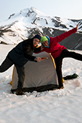
- Ready to tackle the trail!
-
Born2BBrad

- Posts: 1086
- Joined: May 1st, 2011, 7:26 pm
- Location: The Dalles
Re: Timberline Trail 7/20-7/22/14
Sounds like an exciting trip and I’m glad you made it out OK. The Eliot crossing can be difficult if you don’t hit the right spot. It sounds like you crossed up much higher that where the ropes are. Since you have a GPS, what you can do in the future is to get an actual track of your planned route from someone and upload that to your GPS. It’s never a bad idea to be over prepared.
Make now always the most precious time. Now will never come again.
- Jean Luc Picard
Link to GPX tracks
Link to Trip Reports
- Jean Luc Picard
Link to GPX tracks
Link to Trip Reports
-
retired jerry

- Posts: 14426
- Joined: May 28th, 2008, 10:03 pm
Re: Timberline Trail 7/20-7/22/14
Wow! What an experience. Type 2 fun? If it doesn't kill you it makes you stronger?
September is better.
Your descriptions should help others plan for this.
I know what you mean about those slopes getting down to the Eliot. And comitting to a route and then you sort of have to continue. Hard to find a good place. Finding where to get over to the ropes is tricky.
September is better.
Your descriptions should help others plan for this.
I know what you mean about those slopes getting down to the Eliot. And comitting to a route and then you sort of have to continue. Hard to find a good place. Finding where to get over to the ropes is tricky.
-
rainrunner
- Posts: 627
- Joined: June 29th, 2011, 6:55 am
Re: Timberline Trail 7/20-7/22/14
Thanks for the brutally honest report. It really is a great loop ~~ especially in better weather.
The mountains are calling and I must go.
John Muir
John Muir

Re: Timberline Trail 7/20-7/22/14
Sounds like a bitch of a trip, but you 2 kicked Timberline Trail's ass!
You've accomplished something most other humans on the planet will never do.
You've accomplished something most other humans on the planet will never do.

Re: Timberline Trail 7/20-7/22/14
I absolutely loved this trip report. Its always exciting to bite off more than expected and make it through.OneMoreMile wrote:Summary:
Overall, it was difficult, tiring, challenging, beautiful, and thrilling. Would we do it again? Definitely. We’re hooked on backpacking and we’re looking forward to more adventures together.
I've only circum navigated Hood once years back in 07 and remember the river crossings well including the Eliot, we found the rope and even with that it wasn't really "safe" your really exposed to rockfall the entire time. For example here is a photo going down...

and then here is a photo from the same spot looking across the canyon. If you look closely there is a purple rope going straight up the center photo.

lightweight, cheap, strong... pick 2

Re: Timberline Trail 7/20-7/22/14
Thanks for sharing your experience! I feel you pain on a trip not going according to plan...and admire your ability to push through. Looking forward to your next big TR 

Re: Timberline Trail 7/20-7/22/14
Thanks for the excellent trip report. I've been through climbs like that a few times - remembering always turns out more pleasant than doing 
-
adamschneider

- Posts: 3717
- Joined: May 28th, 2008, 10:02 pm
- Location: SE Portland
- Contact:
Re: Timberline Trail 7/20-7/22/14
This report just confirms even more (to me, anyway) that if you want to get across Eliot, you really ought to go way up high (to at least 7200') and cross the glacier. If you really did descend from the west side at the 6800' point on the moraine, you were lucky to make it out of there unscathed!

Re: Timberline Trail 7/20-7/22/14
Gripping! This ought to be considered "required reading" for anyone contemplating that loop.
Thanks for posting that, and welcome to the forum!
Thanks for posting that, and welcome to the forum!
Karl
Back on the trail, again...
Back on the trail, again...