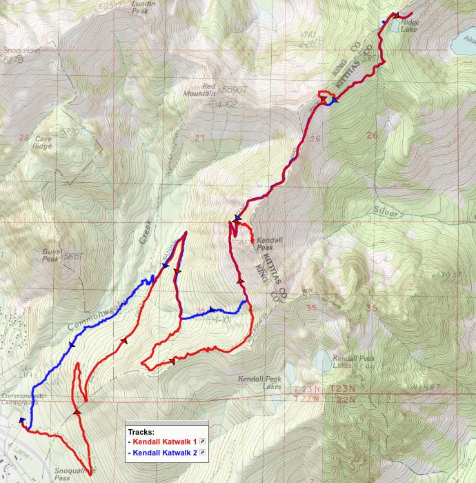
On Friday morning, I hit the road at 4:45am and headed north to Snoqualmie Pass (50 miles east of Seattle on I-90). Just like in Portland, it'd been gray and rainy all week up there, but the weather forecast said Friday would finally turn sunny after some morning clouds. I got to the trailhead just after 8:00.
Most of my itinerary for the day was on the Pacific Crest Trail, but I was planning to start out on a section of the old Cascade Crest Trail that goes up Commonwealth Creek toward Commonwealth Basin and joins up with the PCT after about 1.5 miles. It's a rougher, steeper trail that would save about a mile of walking. But this is what it looked like at its junction with the PCT, just a couple hundred feet from the trailhead:
 Viewed 2465 times")
Oh HELL no, I'm not going into that jungle! Did I mention it'd been rainy? I would've gotten soaked to the skin on that trail. So I took the long, slow, easy way up on the PCT, hoping that I'd be able to take the Commonwealth Creek trail DOWN at the end of the day. I figured this was a possibility because (1) it'd be drier later; (2) even if I got wet, I'd be almost back to the car anyway; and (3) there was a massive WTA work party in the parking lot, on their way to work on "the trail to Commonwealth Basin," someone told me. I hoped that by the time I was coming down, they'd have made some major progress on clearing that brush.
The PCT was ridiculously smooth and evenly-graded; I was 4 miles and 2000' feet above the trailhead before I even took a water break. There were a few rockslide/avalanche openings in the forest, and the views of the nearby peaks should have been great, but mostly I was getting this:
Every now and then, the sun tried to break through the clouds/fog, giving me some nice photos of "Jesus rays" (so called for their frequent appearance on the religious-themed birthday cards that your weird cousins send you).
The openings in the forest weren't exactly a riot of wildflowers, but the flowers that
were there had a lot of photogenic water droplets on them.
As of about noon, the clouds still hadn't broken up, but I was getting
above them, so some of the taller local mountains started appearing.
I'd planned to summit Kendall Peak while I was up there, and I decided to do it sooner rather than later because my legs were fresh
and because it'd kill some time while I waited for the weather to improve. There's a pretty obvious boot path up to the top:
I was hoping that as soon as I crested the ridge, there'd be an amazing cloud-free view out to the east. It didn't quite work out that way, although there were certainly
fewer clouds on the east side than there'd been on the west. The valley of Silver Creek was pretty, and when enough clouds parted — which did happen every now and then — Mt. Stuart (23 miles away) was visible on the horizon:
I ate some lunch on top of Kendall Peak and then headed down. The fog made for some nicely-lit wildflower landscapes, including this huge patch of coiled-beak lousewort:
I dropped back down onto the main trail and headed toward the famous "Kendall Katwalk," a half-mile or so further north. The WTA's hiking guide describes the Katwalk as "a remarkable hiking experience--striding on a narrow shelf hundreds of feet in the air." Oh please... "narrow shelf" my foot.

It was at least 4 feet wide, and frankly pretty underwhelming as a destination. I mean, it's a cool section of trail, but not amazing enough to get its own jauntily misspelled name! (Parts of the Eagle Creek trail are far scarier.)
But, good news: the sun was finally out, and the views were opening up. So I kept going north, trying all the while to remind myself that this was
not a loop, and every step I took would be doubled. I scrambled up a snowfield on the ridge north of the Katwalk in search of an expansive view to the northwest. There were still too many clouds to be able to see distant mountains like Glacier Peak, but I got a great look at Mt. Thomson, which I thought looked like a Pacific Northwest version of Machu Picchu:
Back on the PCT, I started encountering patches of snow here and there, but none of them was big enough to be a hazard or cause navigation difficulties. There was a great viewpoint just before Ridge Lake:
That's Mt. Thomson on the left, with Huckleberry Mountain and Chikamin Ridge on the right, and Lemah Mountain still mostly obscured by clouds on the horizon in the middle.
I walked past Ridge Lake, and looked down at Gravel Lake off to the northwest (but didn't go down to it). I decided my goal for the day would be to get a good look at Alaska Lake, after which I'd start heading back south. So here's the view from my turnaround point:
Then I finally checked my GPS's trip odometer: 8.64 miles. Uh-oh. I was not planning on a 17-mile day! So I resolved to take a couple of shortcuts on the way home.
Walking back across the Kendall Katwalk, I had to admit that the eastward VIEW from there was pretty nice, even if the trail itself was overhyped:
On my way back around the west side of Kendall Peak, I finally got some of the views I'd missed out on due to the morning clouds. Unfortunately, they were now backlit; I swear that Red Mountain had looked much redder than this in the morning!
I said I was planning to take a couple of shortcuts; the first of them was through a big avalanche scar that starts below Kendall Peak and ends half a mile to the west, about 600' or 700' down. I'd noticed potential paths near both the bottom and top of the scar on my way up, so I thought there might be some sort of half-assed trail all the way down. But no... it was mostly just a big bushwhack. A pretty interesting bushwhack, though, because most of my route was walking downhill on old downed trees. And of course there were wildflowers (mostly arnica & daisies/fleabane) all over the place:
The sketchiest part of my downhill avalanche route was that I had to descend a small waterfall/cliff. Fortunately, there wasn't much water going over it, so it wasn't a big problem.
I got back on the PCT headed downhill, and I decided to go ahead with shortcut #2 and take my chances with the old trail along Commonwealth Creek. At its connection with the PCT, there's a sign that says "Trail Abandoned" (actually it just says "Abandoned" now), but most of the trail was in good shape. One of the creek crossings was easy rock-hopping, and the other even had a wire-covered log bridge. The trail was pretty level for the first half mile, but then it started dropping elevation and getting rougher. It turns out that the WTA work party was
not working on this trail; they were headed up the PCT to Commonwealth Basin itself. So yes, I had to muddle through a few hundred yards of the overgrown shrubs from my first photo — but as I'd hoped, they weren't very wet at 6pm.
Final tally: about 14 miles, a little over 3000' in elevation gain. I got back to Portland at about 10:00pm.
Now here's a good question: would I recommend this hike? Probably, as long as you're OK with hiking at least 4 miles through the woods before you get to anything really interesting. However, once you're up above 5000', the elevation changes are minor, and the scenery is incredible. (In that sense, it's a lot like several Mt. Hood hikes, or like the Whitewater Trail to Jefferson Park.) And if it's not wet, I
would recommend going either up or down the Commonwealth Creek trail, to make a partial loop and to save a mile of distance.
[EDIT: Photo album posted:
http://adamschneider.net/photos/2014-07-kk/ ]

