Opening pic
Sunday was a classic Spring Snow Shoe day on Hood. We set out from Sandy at 8:00 with a plan to reprise our previous years trip to Palmateer Point. On the way though we decided that a Blue Grass Ridge, Elk Meadows loop might be more fun on such a sunny day so we headed for the Meadows Nordic Center instead.
Snow shoes were not needed as we set out but we put our micro spikes on. When you head this way in the winter time you never know what the Newton Creek Crossing will be like but on this trip it was an easy crossing on the Summer logs that are still there!

Our snowshoes were still strapped to our packs as we climbed up from the creek but the micro spikes were definitely useful! The snow was in such good condition for walking on we again changed our plan & decided to see if we could make it up Gnarl Ridge & so at the trail junction we set off through the trees in that general direction. No footprints to follow from this point on!

We used the GPS to stay in roughly the same vicinity as the trail but we never actually saw any signs of it.

At about 5800' the snow started to get very sticky & was balling up under our microspikes so we finally put our snowshoes on.

The final half mile of the Gnarl Ridge trail up to the overlook is on a steep side slope and without realizing it we found ourselves climbing above the trail to stay on easier terrain. Before we realized it we we just shy of the Summit of Lamberson Butte looking down on the Timberline trail below us & the Mountain directly in front of us. The perfect Lunch Spot!
Chizuru enjoying the view!

Lunch

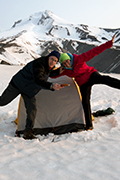
A Celebratory Jump

After Lunch we thought we better head on up the final few feet to tag the summit then return by comming down the south side of the Butte.

Lamberson Butte Summit

The Dwarf Summit Forest!

Heading down the South side.

Heading down the South side.
It was still only early afternoon so we figured we also had time to tag Elk Meadows on the way out & so headed off in that direction once below the Timberline Trail.

Crossing Elk Meadows

The old Elk Meadows Shelter.


Heading Home!
The hike came in at 9 miles with 2575' of EG. Besides my Garmin I took my Galaxy S4 along with Back Country Navigator loaded. On my previous HTC phone this had never been an option as the phone coundn't keep a satellite lock under trees. The S4 did much better, in fact even though I was only carrying it in my trouser pocket it kept a signal lock for the whole hike & there was less than 0.5 of a mile & 150' difference between the 2 in distance and EG. The map below has both tracks loaded & as you can see there is virtually no difference. Of course this doesn't mean I'll be leaving the Garmin at home as I can't put Eric's Gorge Mapset on the phone but it will be a nice second option.

Garmin (Red) versus Samsung S4 (White)
A great day to be out on the mountain!
A few more pics of the day here.