Crossing Eliot Glacier (safely)

This forum is used to share your experiences out on the trails.
User avatar
adamschneider
Posts: 3710
Joined: May 28th, 2008, 10:02 pm
Location: SE Portland
Contact:

Crossing Eliot Glacier (safely)

Post by adamschneider » August 20th, 2012, 10:46 am

2014 NOTE: An update has been posted, with information on crossing both the glacier and the lower washout.

2017 NOTE: There's now an official trail below Cloud Cap. Another update has been posted.

The weekend before last, TWO of my friends -- in different parties -- had trouble with the Eliot Creek washout while circumnavigating Mt. Hood. I decided that the best thing to do was to go up there myself and scout out a safe route from one side to the other.

Note that "safe" is a relative thing! My idea of safe is crossing the glacier itself, but I know glaciers freak some people out. But I'll take my chances with the ice any day, compared to those newly-carved scary vertical walls in the lower part of the outwash plain.

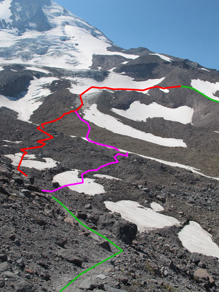
Both of my friends had been headed clockwise around Hood, and both said they walked up the western moraine for a ways and saw what looked like a trail on the other side, heading up toward Cooper Spur. But both realized that going down the near (west) side of the ditch would be an accident waiting to happen; those moraines are too steep and too loose, especially on the west side. What my friends didn't know (but I did, from a 2006 trip up to Langille Crags) was that you CAN get down to the glacier from the west side, but you have to go ALL THE WAY UP THE MORAINE! All the way, that is, until you come to a couple of east-facing vertical cliffs. At that point, you can pick your way down the talus and onto the snowfields, and from there it's actually pretty easy.

I did my reconnaissance mission in the other direction: I parked at Cloud Cap and went up the Timberline Trail to the Cooper Spur stone shelter. From the shelter, there's a very obvious path heading west, which crosses a small ravine and leads to a big man-made rockpile on the crest of the moraine. From the cairn, another obvious path (the one my friends saw) leads down to the glacier. From this point, you can see where you need to go: UP, and mostly west, toward those cliffs, so that you can get up on the other moraine. (See the photo below.)

Image
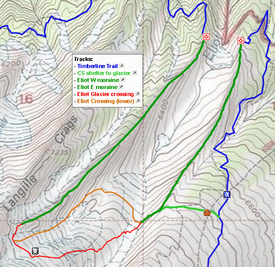
Green = definitely use these paths. Red/purple = improvise.

I walked across lumpy glacial rockpiles, ran up ice fields with little rivulets of meltwater and embedded rocks for easy traction, and finally traversed a big snowfield whose upper slopes led up to a jumbled mess of broken blue ice. That last snowfield had a few nasty crevasses in it; most were below me, but a few small ones were above me too. I didn't feel like I was in any danger, but I might have if I had left my trekking poles at home. Not only can the poles keep you from sliding sideways downhill, you can also use them to test the ice in front of you and make sure it's not hollow.

The last part was actually the hardest: after I left the snow, I had to pick my way across broken boulders to the crest of the ridge, where I found the faint trail leading up from the western moraine. Then I basically went back the way I came, only this time, on the western talus slope, I found a nice seam of REALLY big boulders that weren't going to go anywhere.

So, basically, if you want to go around the whole mountain, I wouldn't recommend risking your life and your possessions in that horrible gulch at the bottom of Eliot Glacier. Just go up higher... and higher. And I hope you enjoy rock-hopping. :)

Here's a map (click for an interactive version), and I'll post pictures once I look through them later today or tomorrow...

Image
Last edited by adamschneider on July 28th, 2019, 6:42 pm, edited 4 times in total.

User avatar
bobcat
Posts: 2757
Joined: August 1st, 2011, 7:51 am
Location: SW Portland

Re: Crossing Eliot Glacier (safely)

Post by bobcat » August 20th, 2012, 10:55 am

Thanks. This is very helpful. I met a couple of parties on the weekend who were going around the mountain and baulking at the crossings of Ladd Creek. I wonder how they're going to fare on this bit . . .

User avatar
adamschneider
Posts: 3710
Joined: May 28th, 2008, 10:02 pm
Location: SE Portland
Contact:

Re: Crossing Eliot Glacier (safely)

Post by adamschneider » August 20th, 2012, 11:08 am

bobcat wrote:I met a couple of parties on the weekend who were going around the mountain and baulking at the crossings of Ladd Creek. I wonder how they're going to fare on this bit . . .
Who knows? It's a completely different kind of sketchiness. There were NO significant stream crossings on the route I took; Eliot Creek doesn't begin until far below the bare part of the glacier.

User avatar
Chase
Posts: 1265
Joined: May 28th, 2008, 10:03 pm

Re: Crossing Eliot Glacier (safely)

Post by Chase » August 20th, 2012, 2:27 pm

Thanks for posting this. I meant to get to that exact area last week to scope it out and the trip never happened. Do you have any GPS waypoints for your route?

One small correction to your excellent post. Although the blue is the TT, it is not the PCT.

User avatar
adamschneider
Posts: 3710
Joined: May 28th, 2008, 10:02 pm
Location: SE Portland
Contact:

Re: Crossing Eliot Glacier (safely)

Post by adamschneider » August 20th, 2012, 2:33 pm

Chase wrote:Thanks for posting this. I meant to get to that exact area last week to scope it out and the trip never happened. Do you have any GPS waypoints for your route?
I can send a GPX file of the red and green lines if you want.
Chase wrote:One small correction to your excellent post. Although the blue is the TT, it is not the PCT.
On the west side of the mountain, between Timberline Lodge and Bald Mountain, it's also the Pacific Crest Trail. I used a track file that included the entire thing. (If you zoom out on the interactive Google version, you'll see what I mean.)

User avatar
rick6003
Posts: 330
Joined: March 30th, 2010, 7:00 pm

Re: Crossing Eliot Glacier (safely)

Post by rick6003 » August 21st, 2012, 8:06 am

Really don't want to say anymore about crossing Elliot. Find where your comfortable to cross.

Anyone that might think about doing the Trip around the mountain may be wise to check it out first if they have any thoughts that it may be a problem. Other than the drive up there its a short walk to the Crossing sign that the Forest Service has put up. Bring binoculars to find the rope on the other side.

(would someone Flag the ropes)

THe other upper crossing requires further climbing but check it out to.

User avatar
kepPNW
Posts: 6411
Joined: June 21st, 2012, 9:55 am
Location: Salmon Creek

Re: Crossing Eliot Glacier (safely)

Post by kepPNW » August 21st, 2012, 11:51 am

rick6003 wrote:its a short walk to the Crossing sign that the Forest Service has put up.
In my best Tim Allen... "Arruughuh?"

They have a sign at the trailhead saying it's closed. There's another pointing to the detour?
Karl
Back on the trail, again...

User avatar
adamschneider
Posts: 3710
Joined: May 28th, 2008, 10:02 pm
Location: SE Portland
Contact:

Re: Crossing Eliot Glacier (safely)

Post by adamschneider » August 21st, 2012, 12:15 pm

kepPNW wrote:They have a sign at the trailhead saying it's closed. There's another pointing to the detour?
There's a sign at the trailhead saying it's closed. There's another one at the Elk Cove/Gnarl Ridge fork just above Cloud Cap:
Image

And another ("TRAIL IS GONE") where the Timberline Trail meets the east edge of the moraine, above the edge of the washout:
Image

Apparently there's a similar one on the TL Trail on the west side. There are NO signs telling you that there's any way to get across Eliot, other than an hour-long car shuttle past Laurance Lake.

User avatar
Peder
Posts: 3401
Joined: May 28th, 2008, 10:02 pm
Location: Lake Oswego

Re: Crossing Eliot Glacier (safely)

Post by Peder » August 21st, 2012, 12:17 pm

Adam - It looks to me as if that trail crosses a snow covered part of the glacier. If so, that should only be crossed in a roped team.
Eliot_Crossing_photomap-Peder.jpg
On a snow covered glacier crevasses are hidden under the snow. With bad luck you can step through a snowbridge and fall into a crevasse. To preempt this, mountaineers travel in teams and are roped up. A cross-section of a crevasse for illustration (with a younger me on the snow bridge for scale!):
Snow bridge.jpg
Snow bridge
You could cross the rubble covered Eliot glacier lower down and then ascend the morraine below the Langille Crags, like Chip and I did last year.

The last two years, the ropes across the lower end of the Eliot gorge have worked well though you should know that there is a risk of rock fall. This crossing looks very impressive, especially when you look straight onto the west side rope from the east side. In practice, with good navigation skills, this crossing felt safe to me in both 2010 and 2011. The difficult bit is finding your way around the rubble at the bottom of the gorge and finding a safe stream crossing.

I may well be going on Sunday, in which case I would be happy to check if it is OK for you to join the party. It would be the same loop as the one I did with Chip last year (see above link).
Some people are really fit at eighty; thankfully I still have many years to get into shape…

User avatar
kepPNW
Posts: 6411
Joined: June 21st, 2012, 9:55 am
Location: Salmon Creek

Re: Crossing Eliot Glacier (safely)

Post by kepPNW » August 21st, 2012, 12:21 pm

adamschneider wrote:There are NO signs telling you that there's any way to get across Eliot, ...
I saw a similar sign at Cloud Cap, which is why I wondered if I had misunderstood Rick's post.
Karl
Back on the trail, again...

Post Reply