6/24/12 Fanton Trail #505 towards Tumalo Mt. (corrected!)

This forum is used to share your experiences out on the trails.
User avatar
mileagemike25000
Posts: 475
Joined: February 8th, 2012, 7:40 pm
Location: Vancouver, WA

6/24/12 Fanton Trail #505 towards Tumalo Mt. (corrected!)

Post by mileagemike25000 » June 26th, 2012, 6:57 pm

This TR was corrected on 6/29/12 to include the proper updated name change from Squaw Mt. to Tumalo Mt. My apologies if
I offended anyone as it wasn't my intention! Thanks to ForestKeeper for providing insight into the name change!


I had been eyeing this trail on my topo maps for a long time. The Fanton trail is located near the SW side of the Salmon-Huckleberry Wilderness. Since information online is rather scarce, we decided to investigate the condition of the trail and try to intersect with the Old Baldy Trail #502 (which leads to many exciting possible hiking opportunities :) ).

Here is the URL for the Old Baldy Trail that I found online:
http://www.mthood.info/hikingtrails/oldbaldy502.pdf

We started the trail at a parking area just off NF-4613. There were no signs or ribbons showing that this was the Fanton Trail #505, just a pile of rocks! :(
1 Fanton Trail not marked!_(1).JPG
Even though the topoquads indicated the trail traveled east from here, we noticed that it also appeared to go west! ;) I wanted to find the true TH for the Fanton Trail #505. Hiking west for about a 1/2mile (the trail was clear and forested) we reached a clearcut. :x We could still see an indentation in the soil where the trail had been and followed it to a gravelled road that had no TH sign. I can only assume that none will be put up and this portion of the trail will eventually be reclaimed?
2 Possible real TH west of parked car_(1).JPG
We turned around and headed back to explore the eastern end of the Fanton Trail.

Oh, I forgot to mention that the Rhodies are beginning to bloom, along with many other flowers! :)
3 Blooming Rhodies!_(1).JPG
Heading back east on the trail we did come across some signs at several of the road crossings along the way.
4 Trail markers sparse but found at road crossings_(1).JPG
There are several ecosystems that are hiked through on this trail. We went through dense Huckleberries and Rhododendrons,
5 Plenty of Huckleberries along trail_(1).JPG
and through forested areas with little undergrowth!
6 Hike through many ecosystems_(1).JPG
And after about 2-2.5miles you will break out into an open area (near/on the road) where people obviously showed no respect for the land! :cry: Fortunately, these next few blocks is where the bulk of the garbage was contained.
7 Obvious signs of people on some road areas_(1).JPG
This area is also where most of the Mt./valley views could be appreciated, and the views were excellent!! :)
8  Great view of Mts from ridge_(1).JPG
The trail along this ridge segment was also alive with plenty of flowers!
9 Flowers are blooming now!_(1).JPG
And I saw this amazing spider (name unknown) that seemed to mimick the unbloomed portion of the Bear Grass flower. :o I swear that this spider looked like the unbloomed flower down to all the shades of colors! It was an amazing example of a symbiotic relationship! And it was very successful after seeing all the dead insects on the flower!
10 Spider looks like unbloomed beargrass on tip of flower!_(1).JPG
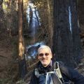
A great view of Tumalo Mt. from trail.
11 View of Tumalo Mt_(1).JPG
We kept hiking and heard a small stream flowing near the trail. We also started seeing the snow from where the stream originated.
12 Stream originating from snow melt_(1).JPG
The snow we saw was off-trail and at an altitude of about 3900ft. It was the only snow we saw all day!
At about 4.5miles from our car we finally intersected with the Old Baldy Trail #502. :D My wife was a bit tired and decided to sit at the trail intersection while I explored the Old Baldy Trail for a short distance in both directions.
13 Wife resting at trail intersection_(1).JPG
There was a sign on the Old Baldy trail that wasn't very obvious unless you looked for it (the original sign looked swallowed by the tree (no picture)).
14 North South trail sign at intersection_(1).JPG
This intersection opens up several new and exciting hiking opportunities! If you travel north on the Old Baldy Trail you can either reach the Old Baldy summit or take the Eagle Creek (other Eagle Creek) Cutoff and head into the Salmon Huckleberry Wilderness.

If you travel south on the Old Baldy Trail you can head up to the summit of Tumalo Mt., hike to Twin Springs or hike to Sheepshead Rock or Plaza Lake!

My wife and I loved this trail and will most certainly be back for more. It offers so many ecosystems and hiking opportunities. In addition, the trail is in exceptional condition with very little debris or blowdowns. We also saw only 1 hiker all day. :) The downside is that there are road crossings and you will see some human refuse in certain areas ( I'm not sure if Clackamas County DumpStoppers would consider removing the garbage?).

There is also plenty of road access closer to the Old Baldy Trail #502 if you don't want to hike the complete Fanton Trail, but instead go into Salmon-Huckleberry Wilderness (the 1 person we met drove his truck to about the 3900ft level and only about 1-1.5 miles from the Old Baldy Trail).

The hiking distance was 11.6miles with an elevation gain of about 1500ft.
15 Fanton Trail #505.JPG
Last edited by mileagemike25000 on June 29th, 2012, 4:38 pm, edited 1 time in total.

sasquatch22
Posts: 267
Joined: October 5th, 2010, 10:43 pm

Re: 6/24/12 Fanton Trail #505 towards Squaw (Tumala?) Mt.

Post by sasquatch22 » June 27th, 2012, 12:05 am

Great trip report and photos, mm25000. That shot of the spider on the Beargrass bloom was intriguing. Thanks for posting.

forestkeeper
Posts: 1291
Joined: July 23rd, 2011, 8:31 pm
Location: Canby, Oregon
Contact:

Re: 6/24/12 Fanton Trail #505 towards Squaw (Tumala?) Mt.

Post by forestkeeper » June 27th, 2012, 3:26 am

:) Thanks for that report Mike. I'll go check it out the weekend after the 4th. I was totally unaware of this trail. Can you post me some directions to the TH? I'll do a campsite cleanup and some trail brushout along with trying to get those trail markers replaced.

Will

User avatar
Splintercat
Posts: 8334
Joined: May 28th, 2008, 10:03 pm
Location: Portland
Contact:

Re: 6/24/12 Fanton Trail #505 towards Squaw (Tumala?) Mt.

Post by Splintercat » June 27th, 2012, 1:36 pm

Mike, the Trail Advocates have good info on this trail over here. Thanks for posting!

Tom :)

User avatar
bobcat
Posts: 2771
Joined: August 1st, 2011, 7:51 am
Location: SW Portland

Re: 6/24/12 Fanton Trail #505 towards Squaw (Tumala?) Mt.

Post by bobcat » June 27th, 2012, 5:37 pm

Trail Advocates also have some information about resurrected trails in the area. For example, a couple of years ago, I did a loop including the Old Baldy, White Iris and Bissell Trails (incorporating a road). You can also drop down from the ridge above Tumala Lakes to the lakes themselves using a use trail. To hike from the lakes out to the road, though, involves some serious squirming through Sitka alder thickets.

User avatar
mileagemike25000
Posts: 475
Joined: February 8th, 2012, 7:40 pm
Location: Vancouver, WA

Re: 6/24/12 Fanton Trail #505 towards Squaw (Tumala?) Mt.

Post by mileagemike25000 » June 27th, 2012, 8:21 pm

sasquatch22 - Thanks! That spider was definitely very interesting. It seemed to always have a snack at hand both on our way out and on the way back.

Tom & Bobcat - Thanks for the info from Trail Advocates! I have looked at their site briefly in the past and should probably consult it more often. That area just seems to be rich in hiking opportunities. :)

Will - Thanks for your feedback! I've been very busy at work and will post some detailed info on this thread tomorrow, if that's okay with you? I've only seen the business card from DumpStoppers but haven't ever contacted anyone before! :( Now that I've joined PH'ers I'll post info about littering when I see it. Your help along with other volunteers in the DumpStoppers organization is GREATLY appreciated! :)

I'm not sure if my directions will be that great as there were a number of turns that I don't remember (my wife was driving and following the GPS voice guidance)? Do you have a car GPS that can route to coordinates as I can give you more precise locations that way? Thanks.

User avatar
RobFromRedland
Posts: 1096
Joined: May 28th, 2008, 10:03 pm

Re: 6/24/12 Fanton Trail #505 towards Squaw (Tumala?) Mt.

Post by RobFromRedland » June 27th, 2012, 8:50 pm

bobcat wrote:Trail Advocates also have some information about resurrected trails in the area. For example, a couple of years ago, I did a loop including the Old Baldy, White Iris and Bissell Trails (incorporating a road). You can also drop down from the ridge above Tumala Lakes to the lakes themselves using a use trail. To hike from the lakes out to the road, though, involves some serious squirming through Sitka alder thickets.
Funny you should mention that loop. I just did it last weekend (in the rain!). Although I still have not been able to find the lower White Iris trail. After looking at maps, etc, I think a tree came down and erased the trail for a portion which is where I ended up losing the trail. I will go back soon and find the last part of the trail. It is a BEAUTIFUL trail, although it is pretty faint in places. The Bissell trail is easy to follow up to Old Baldy. One note - these trails are very old, and not built to Forest Service standards. Many times the trails go straight up or down hillsides, so they can be very steep in places.
Life is not a journey to the grave with the intention of arriving safely in a pretty and well-preserved body, but rather to skid in broadside, thoroughly used up, totally worn out, and loudly proclaiming: WOW! What a ride! - Hunter S. Thompson

forestkeeper
Posts: 1291
Joined: July 23rd, 2011, 8:31 pm
Location: Canby, Oregon
Contact:

Re: 6/24/12 Fanton Trail #505 towards Squaw (Tumala?) Mt.

Post by forestkeeper » June 28th, 2012, 3:10 am

Hey Mike,
No directions are needed. After checking the location out on my FS map, that trail is definitely in the area I work. I'll be up there this weekend for a trail evaluation. As with most primitive campsite trash within the Clackamas Rivers District, I'm the guy that bags it up. I then find a discreet location for Clackamas Dump Stoppers to do a pickup. Dump Stoppers mainly deal with illegal household dumps through out the Clackamas County Forests. But they have a rather huge contract with the Clackamas Rivers Ranger District, of the USFS, so they assist the FS.

Thanks so much for the trail report and the fact that you will return to this trail. If you spot any other trails in the area, that need work, please bring it to my attention, and I'll get it addressed. :)

Will
Last edited by forestkeeper on June 28th, 2012, 8:29 am, edited 1 time in total.

User avatar
bobcat
Posts: 2771
Joined: August 1st, 2011, 7:51 am
Location: SW Portland

Re: 6/24/12 Fanton Trail #505 towards Squaw (Tumala?) Mt.

Post by bobcat » June 28th, 2012, 8:26 am

@RobFromRedland: Looking at my notes on the White Iris - There was a large silver fir down in the clearcut area. After scratching about, I found the trail led straight down, i.e. making a 90-degree turn to the right through the clearcut from the root ball of this fir. There's more blowdown lower down and a hemlock plantation before you reach Road 4615. White irises and solomon plume carpet the whole clearcut and should be blooming around now!

User avatar
mileagemike25000
Posts: 475
Joined: February 8th, 2012, 7:40 pm
Location: Vancouver, WA

Re: 6/24/12 Fanton Trail #505 towards Squaw (Tumala?) Mt.

Post by mileagemike25000 » June 28th, 2012, 6:57 pm

Will - Thanks again and I'm glad that's within the area that you work! :)

I thought I'd give you a heads up on what I observed.

If you go west from our car parking area there is a gas can resting on a log. However, this trail section leads toward the clearcut from which no TH sign exists on the forest road. The coordinates of this item is N45 14.25082; W122 07.459
_06C2589_(1).JPG
This is the beginning of the area on the ridge/road where there are fire pits, ammo shells, printer parts (anyone remember the movie Office Space?) and other debris. The area with the garbage is starting at this point and going east on the road! The coordinates are N45 14.8604 W122 05.2202
_06C2637_(1).JPG
There is a primitive shooting gallery at one of the road intersections past the ridge. The coordinates are N45 14.988; W122 04.27036
_06C2656_(1).JPG
Lastly, after turning right onto this road (you'll see the red arrow on a tree pointing to the trail) there is a clearing past the trail intersection and the stream that has ammo shells and I believe a fire pit (maybe some other debris also). The coordinates of the clearing (that has a view of Squaw Mt.) is N45 14.11556; W122 03.24852
_06C2660_(1).JPG
By the way, since you're an expert on this area I was wondering if we can still call it Sqauw Mt. or should we be using a different name? All the maps I have found still have Squaw Mt. on them but I read that the name was supposedly changed due to a concern about it being derogatory. I don't want to be disrespectful and was not intending to do so! I will correct the TR per your advise! Thanks again.

-Mike

Post Reply