Dollar Fire Update, September 3, 2011, 4:30 pm
The Saturday morning controlled burn operation was delayed due to weather. Work proceeded and burn operations are in progress. Over the next 48 hours, crews will be working to complete, mop up and secure the line along the north and east side of the fire.
In a separate development, unrelated to the controlled burn operation, strong winds out of the east pushed the western flank of the Dollar Lake fire to the west in the Mt. Hood Wilderness. By Saturday afternoon, the fire had spread as far west as Cathedral Ridge and the Mazama Trail area. As soon as the winds subside and smoke clears, fire personnel will develop a more accurate assessment of fire location and size.
The winds out of the east are predicted to diminish later today.Smoke has been heavy and is visible as far west as Portland. Smoke and falling ash have been reported in the Lolo Pass area. Fire officials are working with the Mount Hood National Forest to identify recreation sites, trails and campgrounds that could be affected in the days ahead. As a precautionary measure, recreationists are being asked to pack up and leave some areas.
Three air tankers and three heavy, two medium, and one light helicopter are working the fire. Retardant drops have been approved for Wilderness suppression as part of the aggressive firefighting effort.On the north and east sides of the fire, crews continue to monitor and mop up yesterday's controlled burn. The burnout operation is designed to strengthen fire lines and increase the protection of county and private lands.Protection of historic structures continues with a task force of engines and an extensive sprinkler system in the Tilly Jane and Cloud Cap areas.
Dollar Lake Fire
-
adamschneider

- Posts: 3716
- Joined: May 28th, 2008, 10:02 pm
- Location: SE Portland
- Contact:
Re: Fire closure near Elk Cove, Mt. Hood
-
Splintercat

- Posts: 8333
- Joined: May 28th, 2008, 10:03 pm
- Location: Portland
- Contact:
Re: Dollar Lake Fire
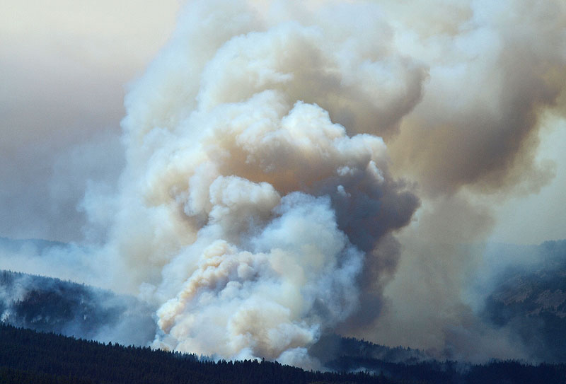
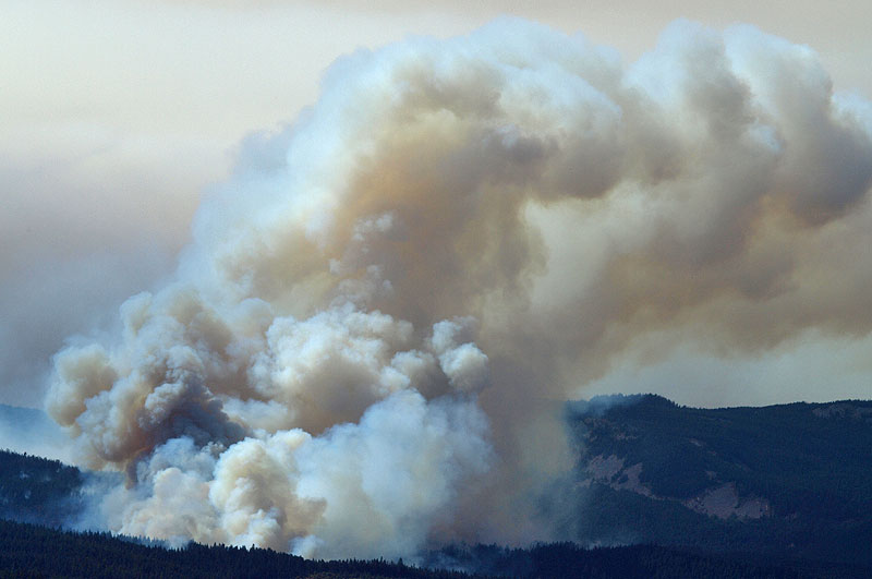
Some photos from around the Dollar Lake Fire this afternoon. The first views are from Bald Butte, where the wind was really gusting at about 1 PM:
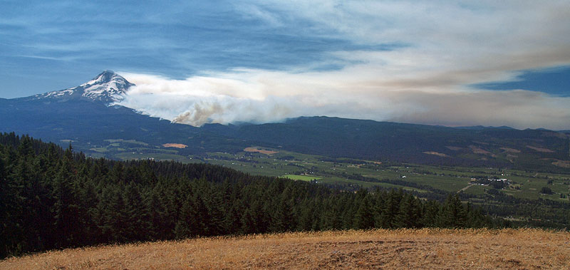
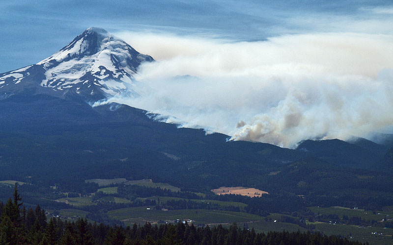
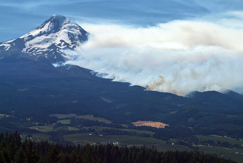
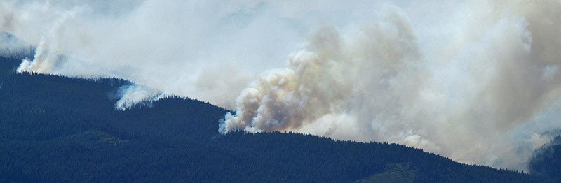
These views are from due east, on Surveyor's Ridge just north of Shellrock Mountain, where we could see huge columns of flame climbing into the smoke plume:
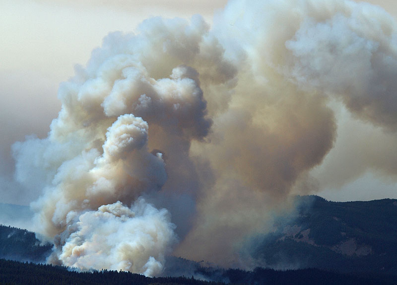
This final shot is from Middle Mountain, looking south -- still the same hot spots burning along the east margin of the fire. It seemed counter-intuitive, given the wind coming from the SE, but with the terrain, I'm thinking that there were all manner of swirling wind patterns within the Coe/Compass canyon complex:
Always impressive to watch, albeit a bit sad, since a lot of reasonably health forest appears to have gone up along with the stuff that really needed to burn. I'm sort of holding my breath to see what it looks like once the smoke clears.
Tom
These views are from due east, on Surveyor's Ridge just north of Shellrock Mountain, where we could see huge columns of flame climbing into the smoke plume:
This final shot is from Middle Mountain, looking south -- still the same hot spots burning along the east margin of the fire. It seemed counter-intuitive, given the wind coming from the SE, but with the terrain, I'm thinking that there were all manner of swirling wind patterns within the Coe/Compass canyon complex:
Always impressive to watch, albeit a bit sad, since a lot of reasonably health forest appears to have gone up along with the stuff that really needed to burn. I'm sort of holding my breath to see what it looks like once the smoke clears.
Tom
-
Splintercat
- Posts: 8333
- Joined: May 28th, 2008, 10:03 pm
- Location: Portland
- Contact:
Re: Dollar Lake Fire
Oh, and I also assembled this photo sequence from the USDA gorge cam today, since what we really saw (apparently) was a major flare-up of the fire, beginning mid-morning. That's when I decided to head over there, after looking at the cam!
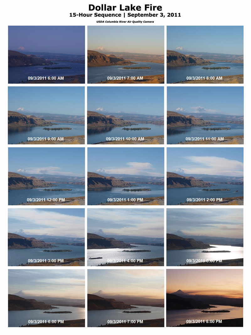
-Tom
-Tom
-
bellaj1018
- Posts: 109
- Joined: May 27th, 2010, 9:32 am
Re: Dollar Lake Fire
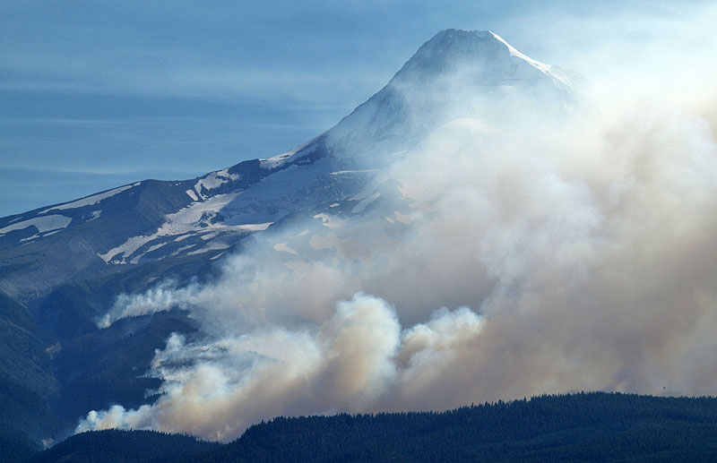
Was up on Lookout Mountain today, which is even further south. Had a great view of the Mother Lode fire in addition to the Dollar Lake fire. Almost looked to me as if there was a 2nd fire burning higher up but I am NO EXPERT here. Was otherwise a beautiful day on Lookout Mntn - can't believe there are still wildflowers up there. AND we had amazing views of Rainier - more clear than I've seen it in a while (a half-hearted thanks to the East wind), We were all very shocked to see how bad the fire was from our vantage point - hoping its not as bad as it looks:(
- Attachments
-
- Is that a 2nd fire?
-
-
- Rainier
-
adamschneider
- Posts: 3716
- Joined: May 28th, 2008, 10:02 pm
- Location: SE Portland
- Contact:
Re: Dollar Lake Fire
Basically, the entire northern half of Hood is now off-limits, including Ramona Falls and McNeil Point. Only the ski areas and Paradise Park are still open.
An area closure is in effect on Mt. Hood National Forest due to the Dollar Lake Fire.
Link to Dollar Lake Fire Closure Order and Map as of 9-3-2011
Several trails and a few campgrounds have been closed to protect the safety of the public. Unfortunately, the public is advised that all closed trails and campgrounds within the closed area are expected to remain closed for the entire Labor Day Weekend. However, the vast majority of trails and campgrounds within Mt. Hood National Forest and outside the closed fire area are open to the public. The following trails and campgrounds are closed.
* The Pacific Crest Trail is closed from Rushing Water Creek crossing north to Wahtum Lake;
* The Timberline Trail #600 is closed from Gnarl Ridge Trail #652 northwest to its terminus at Ramona Fall Trail #797;
* Burnt Lake Trail #772 from the Burnt Lake north trailhead, south to the wilderness boundary;
* Cast Lake Trail #773 and Horseshoe Trail #774 from the trailhead in Riley Campground south to the wilderness boundary;
* Sandy River Trail #770 and Ramona Falls Trail #797;
* Yokum Ridge #771;
* Mazamas Trail #625;
* Vista Ridge Trail #626, Elk Cove Trail #631, and Pinnacle Ridge Trail #630, and all minor trails depicted within the Forest Fire Closure Exhibit A (link to map provided above).
The following campgrounds are closed: Lost Lake, Wahtum Lake, McNeil, Riley Horse Camp, Lost Creek, Kinnikinnick, Tilly Jane, and Cloud Cap.
The Timberline Trail is also open between Mt. Hood Meadows and Timberline Lodge.
It is also possible to hike on Gnarl Ridge Trail #652 to the junction with the Timberline Trail #600. However, the Timberline Trail is closed beyond this junction toward Cooper Spur. The Timberline Trail is open from this junction in the west and south direction toward Mt. Hood Meadows.

-
bellaj1018
- Posts: 109
- Joined: May 27th, 2010, 9:32 am
Re: Dollar Lake Fire
There goes my back up plans including a late Sept. PCT hike from Ramona Falls to Wahtum Lake:(
-
Splintercat
- Posts: 8333
- Joined: May 28th, 2008, 10:03 pm
- Location: Portland
- Contact:
Re: Dollar Lake Fire
Wow. They closed Lost Lake on a Labor Day weekend..! I'm surprised there wasn't rioting up there..!
-Tom
-Tom
-
Waffle Stomper

- Posts: 3707
- Joined: May 28th, 2008, 10:03 pm
Re: Dollar Lake Fire
From Highway 35 this evening.
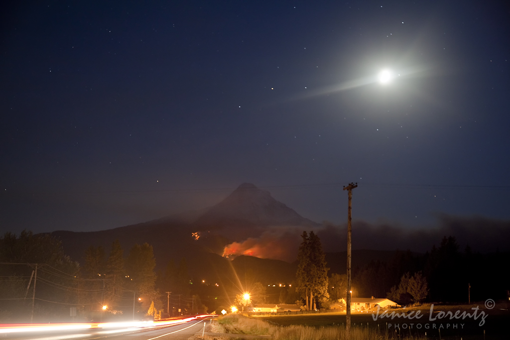
"When we try to pick out anything by itself, we find it hitched to everything else in the Universe." - John Muir
-
Waffle Stomper
- Posts: 3707
- Joined: May 28th, 2008, 10:03 pm
Re: Dollar Lake Fire
I was surprised how much of the lower slopes were impacted when I saw them tonight, but your photos really show the area impacted. Great shots.
"When we try to pick out anything by itself, we find it hitched to everything else in the Universe." - John Muir