Very cool video of the fire:
http://vimeo.com/28359435
Dollar Lake Fire
-
arundodonax

- Posts: 1043
- Joined: August 12th, 2010, 8:02 pm
-
Stevefromdodge

- Posts: 2508
- Joined: May 28th, 2008, 10:03 pm
Re: Fire closure near Elk Cove, Mt. Hood
The MHNF website had a short list of trails that are closed (including a "Pinnacle Trail") and it's been widely quoted by the media. Their map details a larger closure.
I've tried to sort out the horrible map of the closure and determine what trails are really closed. I'm not an official spokesman for anything, but here's how I read the map:
Closed Trails:
Timberline Trail #600 (From McNeil Point Trail Jct-> Cooper Spur Trail Jct)
Eden Park Trail #600H
Vista Ridge Trail #626
Old Vista Ridge Trail #626A
Pinnacle Ridge Trail #630
Dollar Lake Trail #600C
All the use paths to Barrett Spur
Elk Cove Trail #631
Cloud Cap Trailhead Trail
Tilly Jane Trail #600A
Pollalie Ridge Trail #643A
Hope this helps people doing weekend planning.
-
Splintercat

- Posts: 8334
- Joined: May 28th, 2008, 10:03 pm
- Location: Portland
- Contact:
Re: Fire closure near Elk Cove, Mt. Hood
The perimeter map is pretty sweeping -- the bulk of the Elk Cove Trail, the west valley wall of Coe Branch, the ridge end between Coe and Compass, "Canon Ball Falls" on Compass Creek and the bulk of the west face of Stranahan Ridge. Mother nature at work, and lord knows the forest needs the fire. But it will take some getting used to, just as the new landscape on the east side has.
Great video -- truly amazing to watch!
Tom
Great video -- truly amazing to watch!
Tom
-
Waffle Stomper

- Posts: 3707
- Joined: May 28th, 2008, 10:03 pm
Re: Fire closure near Elk Cove, Mt. Hood
Cool timelapse.
"When we try to pick out anything by itself, we find it hitched to everything else in the Universe." - John Muir
Re: Fire closure near Elk Cove, Mt. Hood
Suckage...I have (had) a loop hike planned starting the 13th...
-
adamschneider

- Posts: 3717
- Joined: May 28th, 2008, 10:02 pm
- Location: SE Portland
- Contact:
Re: Fire closure near Elk Cove, Mt. Hood
Interactive map of the fire perimeter as of September 1: http://tinyurl.com/dlf-9-1
-
Stevefromdodge
- Posts: 2508
- Joined: May 28th, 2008, 10:03 pm
Re: Fire closure near Elk Cove, Mt. Hood
Thanks for setting that up Adam.
It looks like the lower portion of the Elk Cove Trail is burnt, as well as a small chunk of the Timberline Trail.
So far, Elk Cove, Dollar Lake and Cloud Cap are all OK.
So far...
It looks like the lower portion of the Elk Cove Trail is burnt, as well as a small chunk of the Timberline Trail.
So far, Elk Cove, Dollar Lake and Cloud Cap are all OK.
So far...

Re: Fire closure near Elk Cove, Mt. Hood
Yes thanks! I was going blind trying to decipher that dreadful PDF map on the FS site!Thanks for setting that up Adam.

Re: Fire closure near Elk Cove, Mt. Hood
That's going to be very hard to put out because of the access and lack of natural fire breaks before it gets too big. And the upcoming weather is going to let it grow pretty large I bet.
I miss being a wildland firefighter. *sigh*
I miss being a wildland firefighter. *sigh*
"If there are no dogs in Heaven, then when I die I want to go where they went."
- Will Rogers
- Will Rogers
-
Splintercat
- Posts: 8334
- Joined: May 28th, 2008, 10:03 pm
- Location: Portland
- Contact:
Re: Fire closure near Elk Cove, Mt. Hood
Wow. While we won't know just how destructive the fire until the smoke clears, that's a pretty clean sweep of the Coe and Compass drainages. Wayne (Koda) was probably the last person to see (the real) Wallalute Falls and Canon Ball Falls on Compass Creek with green timber still standing. It must have been in intuition, Wayne!
I've sketched a rough approximation of the fire's extent shown on Adam's map on this view from Owl Point -- with, the sobering anticipation of what strong, hot winds from the east will mean for the north side in coming days:
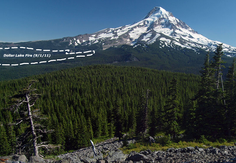
Hopefully, a healthy fire -- that is, a fire that leaves mature trees surviving, and clears out brush and accumulated debris. But given the long history of fire suppression in the area, it's more likely that we'll see a devastating fire more along the lines of the Gnarl Fire.
-Tom
I've sketched a rough approximation of the fire's extent shown on Adam's map on this view from Owl Point -- with, the sobering anticipation of what strong, hot winds from the east will mean for the north side in coming days:
Hopefully, a healthy fire -- that is, a fire that leaves mature trees surviving, and clears out brush and accumulated debris. But given the long history of fire suppression in the area, it's more likely that we'll see a devastating fire more along the lines of the Gnarl Fire.
-Tom