
This this is really a continuation of the Upper Bridal Veil Falls thread in the lost trails forum but since that had drifted off topic a bit I'm continuing it here.
Got my copy of Discovering Old Oregon Series: Volume 1., printed by Frank Amato in the mail today ($1.95) from Powells through Amazon!
Re Dalton I think Zach is on the money it looks like Dalton was the name for what we are now calling Foxglove. If this is the case it seems a bit of a shame to loose this History what do folks think? Maybe we should return to calling Foxglove Dalton & what we have been calling Dalton New Dalton!
Just an idea.
Dalton - Foxglove conundrum!

Re: Dalton - Foxglove conundrum!
Yeah, I could go either way on it. I'm fairly certain today's "foxglove" was Dalton Creek (and falls). Here's my theory on how such a seemingly obscure waterfall made its way onto a map celebrating the then new "historic highway."
At the time the highway was constructed, the region below Angel's Rest had basically been clear-cut. (Look at the trees there today - even the oldest is less than a hundred years old) This would have provided a direct view of the upper canyon where the falls are located.
The trees in the upper canyon are young as well, but for a different reason. The stream springs from dense red and grey clay (its an ashy volcanic layer responsible for many landslides in the Gorge). In the decade prior to the creation of the highway, I'm guessing there was a major slide that cleaned house, scouring the slopes lining the falls. This would have made the falls easily visible.
As they were building the highway, "Dalton Falls" would have been gawked at day in and day out. I'm guessing it was quite scenic. They would have been directly above Dalton Point State Park on the Columbia as well.
Today's "Dalton Falls" has caught on though...(as the falls near Mist Falls), while the original has slowly been overgrown. Nobody but waterfall enthusiasts (and apparently the residents who live on the stream's banks) know about it.
Given that, it might be confusing to switch the name back...but I'm certainly for it if others are. If not, Foxglove still works for me. It certainly is a an interesting piece of history!
*and by the way...$1.95! Grrrr... lol. I spent $17 at the antique store (I looked at it as an investment in research for my book). I should have checked Amazon first I guess!
-Zach

Re: Dalton - Foxglove conundrum!
I personally don't think its really a question of whether it should be 'switched' back or not - if Dalton Falls is on Foxglove Creek, then Dalton Falls is on Foxglove Creek, period. What I'm not at all convinced about, however, is whether Foxglove Falls itself is Dalton Falls or if it occurs further down the canyon (my suspicion) but above the final waterfall which Jamey reached when heading upstream.
Re: Dalton - Foxglove conundrum!
I've followed the whole stream, and there aren't any falls between the 12 fter Jamey photographed, and the main multi-tiered falls a quarter mile further up. Between its just a fairly gentle stretch of cascading water.
Re: Dalton - Foxglove conundrum!
Huh. Guess I'll have to take a better look at it next time I'm down there - maybe see if anything can be seen from Dalton Point.
Re: Dalton - Foxglove conundrum!
Bumping this up for another Google Earth induced epiphany. So the whole Dalton / Foxglove / Mesachie debate and numerous scouting runs into the area provided a lot of information, but frankly none of it convinced me that we'd identified with 100% certainty the real waterfall historically known as Dalton Falls. Now, with Google Earth's terrain model updated with LIDAR data throughout the Columbia Gorge, it provides a much easier method for field checking the various drainages without actually having to field check the various drainages. Once again, referring to the photo in the Arnato book:

We see Dalton Falls immediately east of Angel's Rest, and markedly west of Mist Falls. In reality this gives us about 1.25 miles of the gorge to work with, but there's a ton of drainages in there. But then I noticed something else that was totally overlooked before: the cliff that runs along the road which is popular with climbers, right before crossing Mist Creek, is very clearly marked on this drawing. And Dalton Falls is significantly west of there. So with that now in mind, we have about 3/4 of a mile to work with, and can easily rule out the seasonal falls immediately west of Mist Falls as the real Dalton Falls, because that's the same stream which drops over the roadside climbing cliff.
The other thing that set me off tonight is how severely incised into the gorge this map shows Dalton Falls as being. Obviously the map isn't to scale, but does do a decent job of representing the actual structure of the cliffs in the area. So looking at both Foxglove and Mesachie Creeks, and where the waterfalls on those creeks lie - at around 1450' for Foxglove and 1600' for Mesatchie. The cliffs effectively stop above the 1600 foot mark, so one would assume that either of these falls would be depicted as falling from the top of the cliffs on such a meticulously drawn map. This makes me about 99% certain that none of the streams that have yet been explored harbor the actual Dalton Falls.
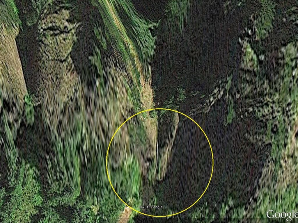
So the question then is where is it? Well, thanks to the LIDAR data in Google Earth, I think I located it. There's a small gully immediately east of Foxglove Creek - about a quarter mile as the bird flies - which doesn't look significant enough to harbor water, but take a look at the current satellite imagery and you'll notice a very distinct yet small slice of white streaming down the rock there. It's even more obvious when you look at it on Google Earth (lat/long: 45.56961, -122.14814) because you can zoom in further. The LIDAR rendering reveals a very distinct two-step cliff there, the upper about 80 feet and the lower about 200 feet, which seems to very nicely correspond with the hand drawn maps that existed back in the day. The location matches up, the incision within the cliffs looks right, and if the forest in there was logged out in the past it certainly would have been visible from the road. The odds of a spring-fed stream in there are quite good, given how many there are throughout the gorge, so the tiny size of the gully and drainage don't necessarily mean anything.
I don't know if there's any way to be 100% certain of this without finding a historical photograph, but to me this looks like the best bet of any of the proposed theories put forth so far.
So who's gonna be the first one to go check it out?
We see Dalton Falls immediately east of Angel's Rest, and markedly west of Mist Falls. In reality this gives us about 1.25 miles of the gorge to work with, but there's a ton of drainages in there. But then I noticed something else that was totally overlooked before: the cliff that runs along the road which is popular with climbers, right before crossing Mist Creek, is very clearly marked on this drawing. And Dalton Falls is significantly west of there. So with that now in mind, we have about 3/4 of a mile to work with, and can easily rule out the seasonal falls immediately west of Mist Falls as the real Dalton Falls, because that's the same stream which drops over the roadside climbing cliff.
The other thing that set me off tonight is how severely incised into the gorge this map shows Dalton Falls as being. Obviously the map isn't to scale, but does do a decent job of representing the actual structure of the cliffs in the area. So looking at both Foxglove and Mesachie Creeks, and where the waterfalls on those creeks lie - at around 1450' for Foxglove and 1600' for Mesatchie. The cliffs effectively stop above the 1600 foot mark, so one would assume that either of these falls would be depicted as falling from the top of the cliffs on such a meticulously drawn map. This makes me about 99% certain that none of the streams that have yet been explored harbor the actual Dalton Falls.
So the question then is where is it? Well, thanks to the LIDAR data in Google Earth, I think I located it. There's a small gully immediately east of Foxglove Creek - about a quarter mile as the bird flies - which doesn't look significant enough to harbor water, but take a look at the current satellite imagery and you'll notice a very distinct yet small slice of white streaming down the rock there. It's even more obvious when you look at it on Google Earth (lat/long: 45.56961, -122.14814) because you can zoom in further. The LIDAR rendering reveals a very distinct two-step cliff there, the upper about 80 feet and the lower about 200 feet, which seems to very nicely correspond with the hand drawn maps that existed back in the day. The location matches up, the incision within the cliffs looks right, and if the forest in there was logged out in the past it certainly would have been visible from the road. The odds of a spring-fed stream in there are quite good, given how many there are throughout the gorge, so the tiny size of the gully and drainage don't necessarily mean anything.
I don't know if there's any way to be 100% certain of this without finding a historical photograph, but to me this looks like the best bet of any of the proposed theories put forth so far.
So who's gonna be the first one to go check it out?
-
BrianEdwards

- Posts: 2405
- Joined: February 2nd, 2010, 1:32 am
- Location: Oregon City, OR
- Contact:
Re: Dalton - Foxglove conundrum!
I believe this is the one Bryan is talking about. Looks like 400' of elevation gain above the road to get there on foot
Clackamas River Waterfall Project - 95 Documented, 18 to go.
Re: Dalton - Foxglove conundrum!
Much to my wife's annoyance whenever I drive this section of 84 I'm looking up at those cliffs & not the road in front of me! I believe you can see this waterfall from one point on the West bound lanes.

Re: Dalton - Foxglove conundrum!
1914 Oregonian article mentioning "Dalton Falls"
I couldn't get the link to work without a login and password. Here's a pic of the article.
I couldn't get the link to work without a login and password. Here's a pic of the article.
"I arise in the morning torn between a desire to improve the world and a desire to enjoy the world. This makes it hard to plan the day.”
― E.B. White
― E.B. White
-
Splintercat

- Posts: 8333
- Joined: May 28th, 2008, 10:03 pm
- Location: Portland
- Contact:
Re: Dalton - Foxglove conundrum!
Bringing up one of the earlier threads on this topic, with some reposted images from my original trip report. I don't think Foxglove was ever named as "Dalton" -- it's just not large enough, and is way above the old highway... and possibly a bit out of sight, as it faces west. You can clearly see it through the trees in my photos, so it's definitely where I located it on the maps -- which is far above the falls shown in the old Gorge sketch map.
I think Dalton is more likely one of the drops that can be seen to the east. It's also not impossible that a change in water table or some other geomorphology has reduced the flow to become seasonal over the past century -- that can happen, and so one of the gullies that Bryan points out could have had a larger/more consistent flow when the Dalton name was applied.
Zach, did you get a good view of the falls in my photos from creek level? I'm really not sure it's possible to get a great view (barring another forest fire).
Tom