Mt. Margaret Backcountry map & GPS data

General discussions on hiking in Oregon and the Pacific Northwest
User avatar
adamschneider
Posts: 3717
Joined: May 28th, 2008, 10:02 pm
Location: SE Portland
Contact:

Mt. Margaret Backcountry map & GPS data

Post by adamschneider » September 26th, 2014, 2:36 pm

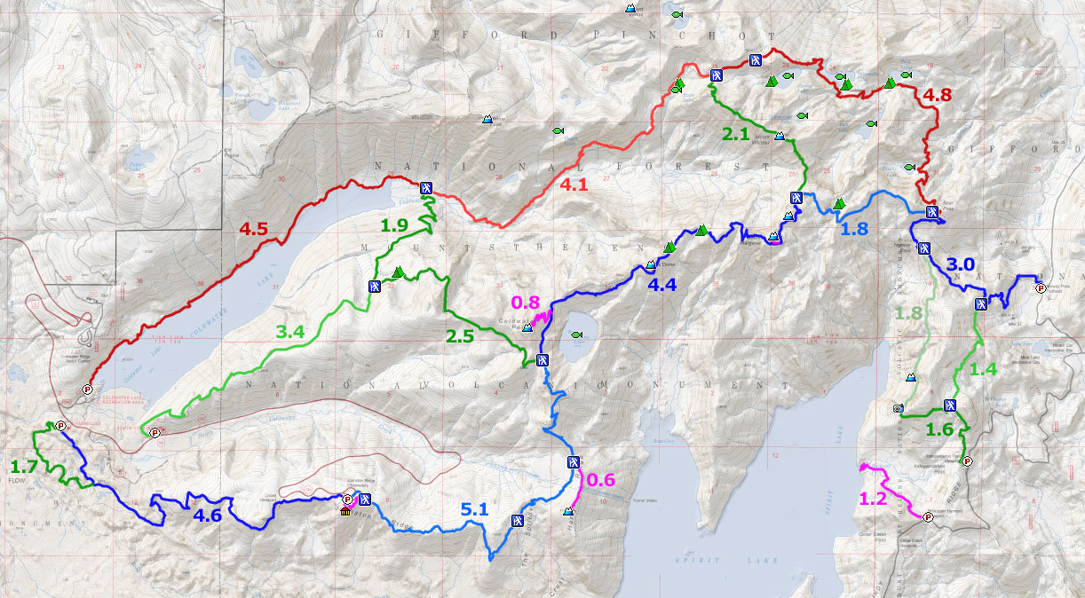
Anyone who's tried to get info about trails and campsites in the Mt. Margaret Backcountry from the USFS Web site knows that it's nearly useless; the one map they have available looks like it's been faxed and photocopied several times. So, while I was doing some trip planning for a Coldwater Peak loop, I decided to just go all-out and trace ALL of the major trails up there, calculate some distances, and make them publicly available:

http://adamschneider.net/hiking/Mt_Marg ... untry.html

On the map page, there's a link to a GPX file containing all the data that's on the map.

Mostly I traced aerial photos to create the tracks, but I also used my own hiking tracklogs plus as many as I could find on the Internet... so you can mostly thank Karl Peterson's GPSFly account for the bits I haven't personally explored yet. :)

Image

User avatar
kepPNW
Posts: 6411
Joined: June 21st, 2012, 9:55 am
Location: Salmon Creek

Re: Mt. Margaret Backcountry map & GPS data

Post by kepPNW » September 26th, 2014, 2:53 pm

Very nice!!!

I see just one short option still missing - the longer way back through the Hummocks. It's kind of nice, when there's still a bit of day left, as it offers a chance to get to the shore of the Toutle River, as well as passes through an area dammed by beavers. The purple/blue track(s) shown in the attached map are available at http://gpsfly.org/g/2551 and/or http://gpsfly.org/g/1965.
Capture.JPG
Area around the Hummocks.
Karl
Back on the trail, again...

User avatar
adamschneider
Posts: 3717
Joined: May 28th, 2008, 10:02 pm
Location: SE Portland
Contact:

Re: Mt. Margaret Backcountry map & GPS data

Post by adamschneider » September 26th, 2014, 3:09 pm

kepPNW wrote:I see just one short option still missing - the longer way back through the Hummocks.
Everyone's a critic. ;)

I was sick of staring at Google Earth! When I get some more time, I'll add that and the Independence Pass Trail (anyone got any GPS tracks of that?).

User avatar
kepPNW
Posts: 6411
Joined: June 21st, 2012, 9:55 am
Location: Salmon Creek

Re: Mt. Margaret Backcountry map & GPS data

Post by kepPNW » September 26th, 2014, 3:52 pm

adamschneider wrote:
kepPNW wrote:I see just one short option still missing - the longer way back through the Hummocks.
Everyone's a critic. ;)
Heh. :D
adamschneider wrote:I was sick of staring at Google Earth! When I get some more time, I'll add that and the Independence Pass Trail (anyone got any GPS tracks of that?).
The portion on the lakeside is "officially" closed due to landslide. I do believe that when Sean last did the loop, though, the signs were only at the opposite end he approached from!
Karl
Back on the trail, again...

User avatar
Eric Peterson
Posts: 4097
Joined: May 11th, 2009, 5:39 am
Location: Oregon
Contact:

Re: Mt. Margaret Backcountry map & GPS data

Post by Eric Peterson » September 26th, 2014, 4:32 pm

Nice job Adam! :)

Steve20050
Posts: 395
Joined: November 12th, 2009, 8:06 pm

Re: Mt. Margaret Backcountry map & GPS data

Post by Steve20050 » September 26th, 2014, 6:43 pm

Now if you would have posted this last weekend I could have used it :P Thanks though, it is better than what I've got. My old Geo Graphics map has been taped and re taped. It doesn't have the mileage either. Anyways, having been just there, I can confirm there is a sign posted at Norway pass junction to the Independence trail that says it is closed due to landslide. One of the only signs I've seen that isn't on the ground or so old you can't read it. Out on 227, not sure?

Come to think of it there are also a couple warning signs that let you know the area is restricted on the south side of the Boundary trail that are still up. I guess they have what they consider important covered :? . I have been thinking about complaining/asking why they can't do a bit of work on the signage and trail deterioration, but I expect again our fees are going somewhere else??? Ok. enough said. It was beautiful out there the other day and after Sunday, I didn't see a soul for a couple days.
Surridge
Posts: 102
Joined: April 2nd, 2014, 7:34 pm

Re: Mt. Margaret Backcountry map & GPS data

Post by Surridge » September 27th, 2014, 8:26 am

Adam, thanks so much for this. Nice work

User avatar
Born2BBrad
Posts: 1086
Joined: May 1st, 2011, 7:26 pm
Location: The Dalles

Re: Mt. Margaret Backcountry map & GPS data

Post by Born2BBrad » October 1st, 2014, 1:56 pm

Great map Adam!

I used the mileage, tracks and waypoints to make an even more customized map of the Mt. Margaret Backcountry area. I'll get to use it this weekend. The tracks and waypoints have already been added to my GPS. One can never be too prepared.

It's great how map, mileage, track and waypoint information can be shared these days.

Hike on,

Brad
Make now always the most precious time. Now will never come again.
- Jean Luc Picard

Link to GPX tracks
Link to Trip Reports

Chico
Posts: 3
Joined: April 12th, 2013, 6:51 pm

Re: Mt. Margaret Backcountry map & GPS data

Post by Chico » October 2nd, 2014, 8:30 pm


User avatar
adamschneider
Posts: 3717
Joined: May 28th, 2008, 10:02 pm
Location: SE Portland
Contact:

Re: Mt. Margaret Backcountry map & GPS data

Post by adamschneider » October 2nd, 2014, 10:57 pm

Unfortunately, the tracks in that file are just the ones already printed on the topo map and don't always reflect realty. For example, you could get into a very bad spot on the west side of Whittier Ridge if you followed the USGS data.

Post Reply