Before I headed up to maintain a few campgrounds near Bagby Hot Springs, I was briefed on the 36 Pit Fire. As of this morning, September 19th, 2014, the fire is 35% contained, which has consumed 4,100 acres. As shown on a fire map, the fire line stretches from Promatory Park east to Carter Bridge on the Hwy 224 side of the
Clackamas River. On the south side of the Clackamas, across from Lazy Bend to Memaloose and is burning south, southwest.
Lazy Bend campground is destroyed, as well as Big Eddy Day Use Area, and Carter Bridge Campground. The area of Memallose Falls is destroyed and most likely Hillockburns Springs and the trail. Hwy 224, from Promatory Park eastward to Carter Bridge has been nearly destroyed by landslides. It is closed from Fall Creek Rd to Hwy 57, just past Ripplebrook Guard Station. All trails in that area are closed. Hillockburns Rd (FR 45) is closed. So Memaloose Lake Trail, Clackamas River Trail, Cripple Creek and Grouse Pt trails are closed. All trails located off of FR 4610 are also closed. Any access to anything east of Ripplebrook must be via Hwy 26 east to Skyline Rd (FR 42) to Timothy Lake, then Hwy 57 south to Hwy 46.
As of 3:00 pm, an air tanker and two helicopters were enroute from Redmond to the fire.
36 Pit Fire- Unofficial Report + Trail Closures
-
forestkeeper
- Posts: 1291
- Joined: July 23rd, 2011, 8:31 pm
- Location: Canby, Oregon
- Contact:
-
BrianEdwards

- Posts: 2405
- Joined: February 2nd, 2010, 1:32 am
- Location: Oregon City, OR
- Contact:
Re: 36 Pit Fire- Unofficial Report + Trail Closures
Looking at the fire map, hillockburn spring may have fortunately survived. Someone needs to do a recon into the south fork and see how much of the waterworks and trestle are left. Angel Falls will now be in wide open view from 224 near Carter Bridge.
Clackamas River Waterfall Project - 95 Documented, 18 to go.
-
greenjello85
- Posts: 554
- Joined: July 31st, 2014, 1:31 pm
Re: 36 Pit Fire- Unofficial Report + Trail Closures
The fire has jumped the line and is very close to some residences on hillockburn rd. High east winds have caused it to flair up again. 
-
BrianEdwards
- Posts: 2405
- Joined: February 2nd, 2010, 1:32 am
- Location: Oregon City, OR
- Contact:
Re: 36 Pit Fire- Unofficial Report + Trail Closures
Errrr! Hope nobody suffers any property damage
Clackamas River Waterfall Project - 95 Documented, 18 to go.
-
derwoodynck

- Posts: 286
- Joined: April 21st, 2013, 2:26 pm
- Contact:
Re: 36 Pit Fire- Unofficial Report + Trail Closures
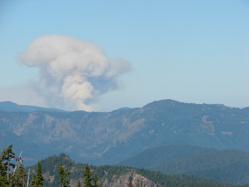
We were up on Battle Ax today and noticed the smoke plume really explode a little before 1:30pm.
This was the smoke at 12:53
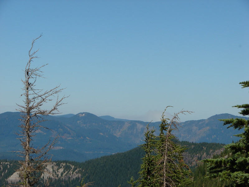
And 1:30
This was the smoke at 12:53
And 1:30
-
Splintercat

- Posts: 8334
- Joined: May 28th, 2008, 10:03 pm
- Location: Portland
- Contact:
Re: 36 Pit Fire- Unofficial Report + Trail Closures
Excellent pics! We saw that plume from the Milwaukie area today, turned into a full-blown anvil "cloud" and it looked like it was moving south. I said an R.I.P. for the South Fork canyon (which I have never visited, sadly).
Tom
Tom
-
Splintercat
- Posts: 8334
- Joined: May 28th, 2008, 10:03 pm
- Location: Portland
- Contact:
Re: 36 Pit Fire- Unofficial Report + Trail Closures
The updated KML isn't loading at the largest scales on the InciWeb site, but it looks like the entire lower canyon of the South Fork was swept over yesterday. Hopefully, a mosaic burn that didn't crown the big trees, but with the winds gusting at 40 mph, that's just me being optimistic. I do hope the shooters who started this fire are located and prosecuted. Ironically, the penalty for this crime will be much less harsh if no homes are destroyed -- as if the South Fork (or Clackamas River Canyon, in general) aren't infinitely more valuable than anything mere humans can build (and easily rebuild).
Tom
Tom
-
RobFromRedland

- Posts: 1096
- Joined: May 28th, 2008, 10:03 pm
Re: 36 Pit Fire- Unofficial Report + Trail Closures
Tom:
There might yet be hope for the canyon - I had heard that the fire has mostly been ground fires - not much in the way of canopy burning/torching. There has been some for sure, but they said it was mostly on the ground burning ground fuels. If that is indeed true, most of the old growth will survive this disaster. I sincerely hope that is the case.
The flareup on the south fork yesterday was unwelcome news. Sounds like all the activity to the north is pretty much controlled. All the activity seems to be on the south side of the fire now. Hopefully they will get it under control and/or we get some good rain this week. I am ready for some of the fall rains to begin.
Life is not a journey to the grave with the intention of arriving safely in a pretty and well-preserved body, but rather to skid in broadside, thoroughly used up, totally worn out, and loudly proclaiming: WOW! What a ride! - Hunter S. Thompson

Re: 36 Pit Fire- Unofficial Report + Trail Closures
Well crap, there goes my plans for hitting the South Fork this year. One possible upside to this situation though is this could provide an impetus for the FS to consider building an official trail along the old water works route to avoid contributing to unnecessary erosion, since people will no doubt continue to visit.
-
RobFromRedland
- Posts: 1096
- Joined: May 28th, 2008, 10:03 pm
Re: 36 Pit Fire- Unofficial Report + Trail Closures
It still might be possible to get up there this year, depending on when they get the fire under control. Once the rains start it might be accessible. The one unknown is how long until both 224 and road 45 are re-opened.
At this point, I highly doubt that the bridge at the confluence of Memaloose and the South Fork survived. That whole area has now burned - I'm glad I got to see those waterfalls before it burned. I guess you could look at the bright side - this fire may make it easier to get around in there, getting rid of all the brush. But there will probably be new downed, burned trees to navigate around.
At this point, I highly doubt that the bridge at the confluence of Memaloose and the South Fork survived. That whole area has now burned - I'm glad I got to see those waterfalls before it burned. I guess you could look at the bright side - this fire may make it easier to get around in there, getting rid of all the brush. But there will probably be new downed, burned trees to navigate around.
Life is not a journey to the grave with the intention of arriving safely in a pretty and well-preserved body, but rather to skid in broadside, thoroughly used up, totally worn out, and loudly proclaiming: WOW! What a ride! - Hunter S. Thompson