Page 1 of 2
Weather stats
Posted: January 9th, 2013, 8:08 am
by drm
Many have probably heard the stats that the US had it's warmest year on record in 2012, breaking the previous record by a full degree, which is a large amount to break such a record by. The details are a bit interesting to us PNWers. 19 states also had their warmest year and 26 had temps in their top 10 warmest. Not surprising to us, however, the remaining three continental US non-top-ten states include Oregon and Washington (as well as Georgia with it's 11th warmest). Oregon had it's 12th warmest and Washington it's 30th warmest. These stats are all taken from 118 years or records I think, we were still above average.
It's not that I want a warmer summer, but I do wish that the summer would start a bit earlier and mainly I hope for a nice Spring.
Re: Weather stats
Posted: January 9th, 2013, 8:19 am
by pdxgene
Yeah, having the warm sunny weather in alignment with the longest days and shortest nights (May/June/July instead of Septtember) would sure be a nice change from the past few years.
Re: Weather stats
Posted: January 9th, 2013, 8:29 am
by retired jerry
But, being a "cup half empty" type of person, maybe that means the ocean will evaporate more water so it will be cloudier and rainier here
And there will be more snow so it will take longer to melt off

Re: Weather stats
Posted: January 9th, 2013, 9:20 am
by pdxgene
retired jerry wrote:But, being a "cup half empty" type of person, maybe that means the ocean will evaporate more water so it will be cloudier and rainier here
No worries, the melting polar ice caps will compensate. It all evens out

Re: Weather stats
Posted: January 9th, 2013, 11:10 am
by kepPNW
retired jerry wrote:But, being a "cup half empty" type of person, maybe that means the ocean will evaporate more water so it will be cloudier and rainier here
We also had our 3rd wettest year ever, last year, I believe. I think that's the direction this corner of the country will go, wetter and a bit warmer. Enough so that the dam folks are planning for much less reserve (snow pack) in the mountains, and the need to bottle more up in the rivers.
Re: Weather stats
Posted: January 9th, 2013, 11:42 am
by drm
retired jerry wrote:But, being a "cup half empty" type of person, maybe that means the ocean will evaporate more water so it will be cloudier and rainier here
And there will be more snow so it will take longer to melt off
It should be cloudier and rainier somewhere, but more snow is a question. With a higher average snow line, there will be more snow higher up and less snow lower down. How those two balance out is hard to say.
Re: Weather stats
Posted: January 9th, 2013, 12:05 pm
by kepPNW
drm wrote:It should be cloudier and rainier somewhere, but more snow is a question. With a higher average snow line, there will be more snow higher up and less snow lower down. How those two balance out is hard to say.
Not in the long term. There's a rapidly diminishing amount of "higher up" the higher up you go. Not gonna "make it up with volume" in most scenarios.
Re: Weather stats
Posted: January 9th, 2013, 12:35 pm
by payslee
this has been an area of intensive research and modeling for the last decade or so by land management and water supply agencies.
Here's Oregon's "best guess" on our local piece of the oncoming global pie:
http://www.oregon.gov/energy/GBLWRM/doc ... _guide.pdf
The buzzwords are "climate adaptive management" if you feel like googling for a huge amount of studies and a fair sprinkling of speculation.
-payslee
Re: Weather stats
Posted: January 9th, 2013, 3:21 pm
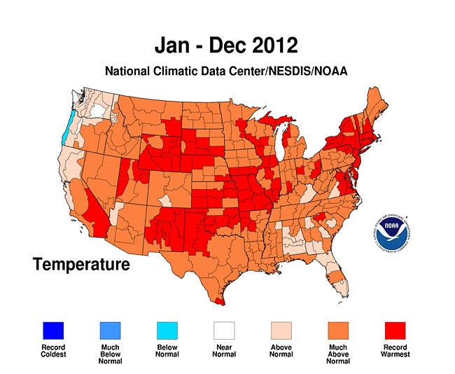
by oldandslow
It is interesting to look at the National Climatic Data Center temperature map for the year.
http://www.ncdc.noaa.gov/sotc/service/n ... 201212.gif
The Oregon Coast was the only place in the country with below normal temperatures. The northern Oregon Cascades and southeast Washington were among the relatively few places near normal.
Re: Weather stats
Posted: January 9th, 2013, 4:29 pm
by drm
kepPNW wrote:drm wrote:It should be cloudier and rainier somewhere, but more snow is a question. With a higher average snow line, there will be more snow higher up and less snow lower down. How those two balance out is hard to say.
Not in the long term. There's a rapidly diminishing amount of "higher up" the higher up you go. Not gonna "make it up with volume" in most scenarios.
It depends on how long term and how high. It will take longest for Mt Rainier to pass that threshold since it's highest glaciers may gain for some time to come.
I also saw a presentation on Mt Adams last year. Similarly, the highest glaciers are not yet thinning but the altitude of the terminus is increasing, and the lower-level glaciers are fast disappearing.