Starvation Loop Update (March 10)

Use this forum to report and discuss trails in need of maintenance. This will help organizations like TKO and agencies like the Forest Service get the most recent on-the-ground trail conditions.
Post Reply
User avatar
Splintercat
Posts: 8333
Joined: May 28th, 2008, 10:03 pm
Location: Portland
Contact:

Starvation Loop Update (March 10)

Post by Splintercat » March 11th, 2012, 12:02 pm

Some good news on the Starvation Loop: the USFS will have a crew in there at some point this spring, though they've got a lot of logs down this year. Word is that the 400 trail is the current priority, but Starvation will follow shortly thereafter.

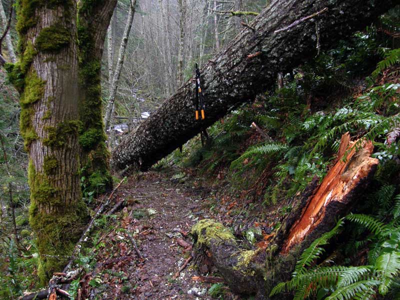
I've got a March 25 Friends of the Gorge group (of 25!) that I'm supposed to lead through the loop, so have been worried about whether the amount of downfall would be too much to navigate with a group that size. Last week, I cleared the Starvation Cutoff trail of smaller stuff, and it's easily passable now. So, I headed up again yesterday, but this time worked from the reverse direction, coming in from the west. As expected, there was quite a lot of downfall on the inner slopes of Warren Creek canyon. The major barrier here is a large log that fell diagonally across the trail, just short of the Warren Creek crossing -- that's my 42" loppers hanging on the log for scale:

Image

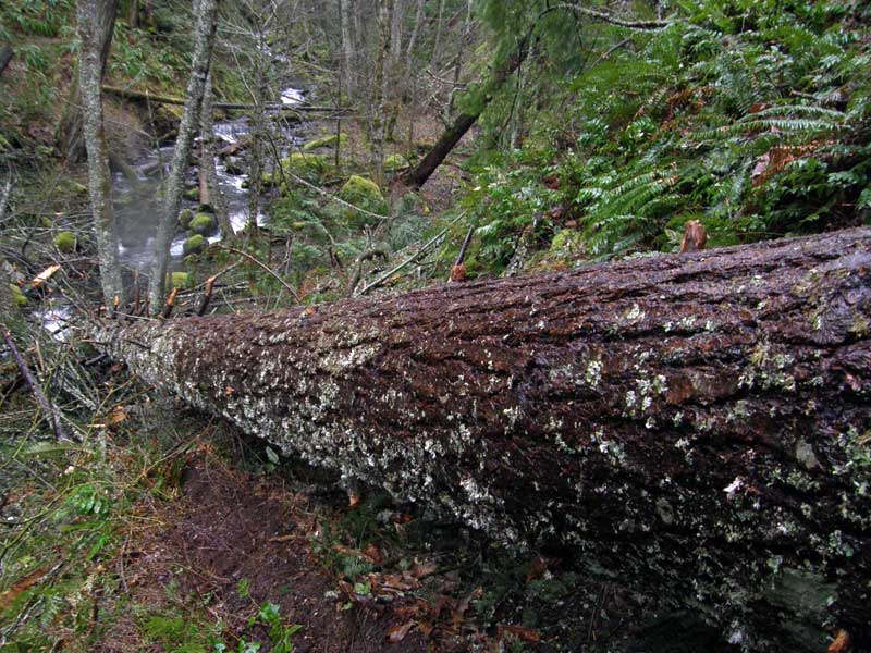
Another view, peeking over the log -- but before I'd had a chance to clear the trail on the opposite side. It's now cleared except for the big log, which requires a slightly sketchy bear-hug-and-roll technique... ;)

Image

There is a huge downfall in the hanging meadow east of Warren Creek. There's no good way to navigate this one, unfortunately, though it's not unsafe to cross. The trail tread has been damaged by this one, as well. I clipped away at some of the limbs to provide a clear path to the best crossing spot, but it's also not an idea situation for hikers:

Image

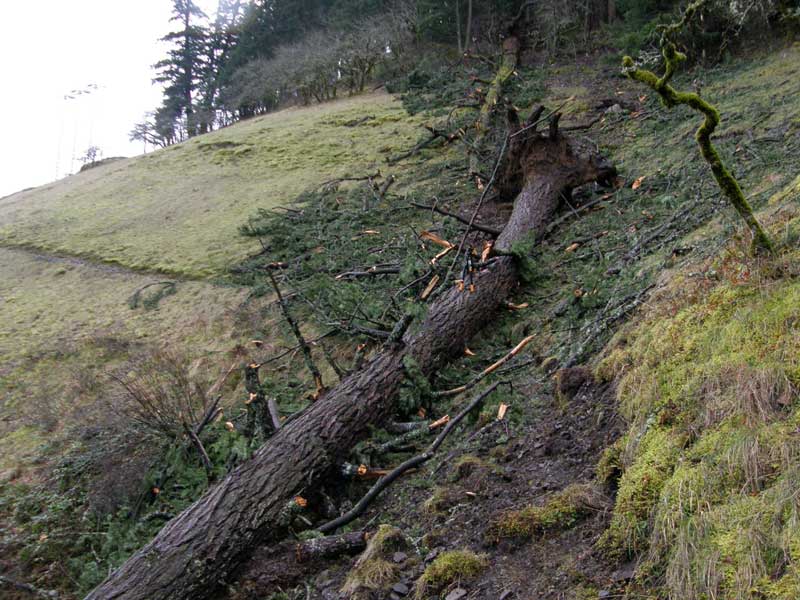
(look closely, and you can see my loppers just below the break in the tree trunk -- big tree!)

I really bogged down as I dropped into the Cabin Creek drainage, as expected. After a bit of clearing, I skipped over two sections that will require quite a bit more work, so that I could figure out if the lower section I'd looked at last weekend was even passable. The good news is yes -- with some more work on the small stuff, the section near the creek is reasonably passable, even if the USFS crews don't make it out there for a bit. I made a pretty good dent in this area, but left this section for next weekend:

Image

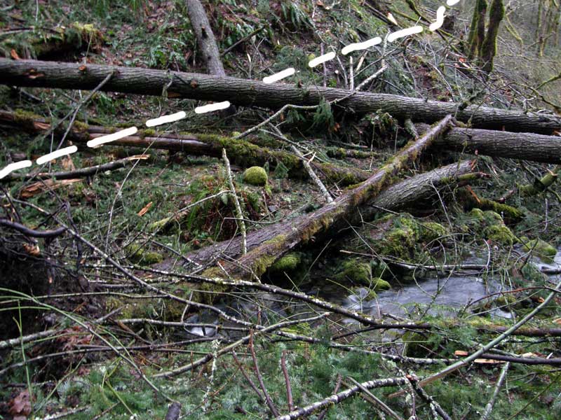
Messy! The weird thing about this storm event is the amazing amount of small first boughs that are everywhere, and totally concealed the trail in many spots. My guess is that they were covered in ice from a freezing rain episode, then hit with high winds..? Mother nature doing her pruning, big time!

It will be a few years before these canyons recover. Cabin Creek, in particular, was a lovely little corridor of ferns and vine maple, but will take awhile to return to that state. This is the worst storm damage I've seen in this area in memory.

-Tom

User avatar
Eric Peterson
Posts: 4097
Joined: May 11th, 2009, 5:39 am
Location: Oregon
Contact:

Re: Starvation Loop Update (March 10)

Post by Eric Peterson » March 11th, 2012, 12:06 pm

Cool Tom . . . any word on 413, Defiance Trail?

I saw the PCTA planned trail work for Starve Ridge in the RX area...

User avatar
Splintercat
Posts: 8333
Joined: May 28th, 2008, 10:03 pm
Location: Portland
Contact:

Re: Starvation Loop Update (March 10)

Post by Splintercat » March 11th, 2012, 12:17 pm

Not that I've seen beyond trip reports here, Eric -- in fact, I kind of remember a report saying that Defiance was spared by the downfall event..?

I missed the PCTA mention of Starvation -- which thread was that in? I sent off an e-mail to Tammy, as I was wondering the same thing.

Tom

User avatar
Eric Peterson
Posts: 4097
Joined: May 11th, 2009, 5:39 am
Location: Oregon
Contact:

Re: Starvation Loop Update (March 10)

Post by Eric Peterson » March 11th, 2012, 12:21 pm

rcPDX wrote:
We're working on plans for Starvation Ridge, Eagle Creek, and slide clearing on Wahkeena.
You commented in the thread as well, right under this thread :)

User avatar
Splintercat
Posts: 8333
Joined: May 28th, 2008, 10:03 pm
Location: Portland
Contact:

Re: Starvation Loop Update (March 10)

Post by Splintercat » March 11th, 2012, 1:34 pm

Thanks, Eric... sometimes I need to be thumped over the head in order to notice the obvious...

-Tom :lol:

User avatar
Grannyhiker
Posts: 4598
Joined: May 28th, 2008, 10:03 pm
Location: Gateway to the Columbia Gorge

Re: Starvation Loop Update (March 10)

Post by Grannyhiker » March 12th, 2012, 9:06 am

That first log looks like the type I manage to crawl up on and then get stuck! :lol: The second one doesn't look bad at all thanks to your clearing the branches.

I take it this is the lower loop, not the BIG one up to the top, which is a bit beyond my capabilities?

As always, thanks for your hard work!

User avatar
Splintercat
Posts: 8333
Joined: May 28th, 2008, 10:03 pm
Location: Portland
Contact:

Re: Starvation Loop Update (March 10)

Post by Splintercat » March 12th, 2012, 11:51 am

That's right, Granny -- I should have linked to the PH Field Guide, but this is the "Lower Starvation Hike" as described in the field guide. By my calculation, just under three miles, but with an 1,000 foot elevation gain..! Steep, when you consider that most of the climbing occurs over about a mile of that distance.

Tom

Post Reply