
- Shot from viewpoint before boulder scramble.
Big Rock on Table
-
Don Nelsen

- Posts: 4382
- Joined: May 28th, 2008, 10:03 pm
- Location: Vancouver, WA
Re: Big Rock on Table
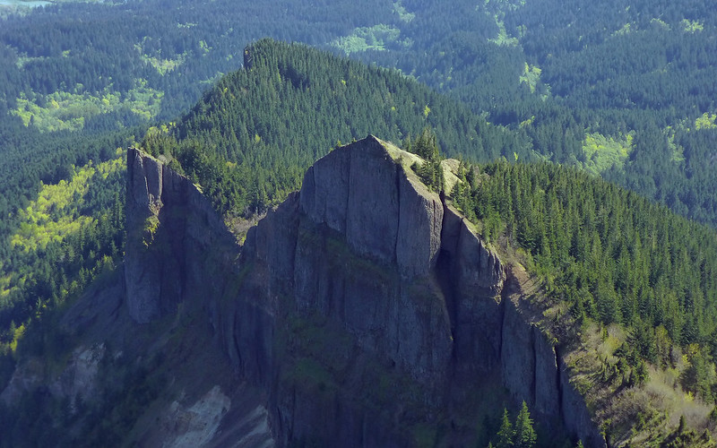
That rock is one of the "Two Chiefs"
dn
dn
"Everything works in the planning stage" - Kelly
"If you don't do it this year, you will be one year older when you do" - Warren Miller
"If you don't do it this year, you will be one year older when you do" - Warren Miller
Re: Big Rock on Table
Ah-ha! Of course. I am going to remember that, this time.Don Nelsen wrote:That rock is one of the "Two Chiefs"
So the one pictured above is the yellow arrow in this shot, and presumably the red arrow is pointing at the other "Chief"?
Karl
Back on the trail, again...
Back on the trail, again...
-
Don Nelsen
- Posts: 4382
- Joined: May 28th, 2008, 10:03 pm
- Location: Vancouver, WA
Re: Big Rock on Table
I've always called them the big chief and the little chief, the big one being the larger and more northern one. You can do a short bushwhack to the summit of either one and it is a real rush to peer over the edge down the cliffs! BTW, there is a large crack developing on the south side of one of them, I think it is the southern one, I don't remember just now, so in the future, the profile will certainly change!kepPNW wrote:Ah-ha! Of course. I am going to remember that, this time.Don Nelsen wrote:That rock is one of the "Two Chiefs"
So the one pictured above is the yellow arrow in this shot, and presumably the red arrow is pointing at the other "Chief"?
Thanks, Don!
Don
"Everything works in the planning stage" - Kelly
"If you don't do it this year, you will be one year older when you do" - Warren Miller
"If you don't do it this year, you will be one year older when you do" - Warren Miller
Re: Big Rock on Table
Fascinating! I'm going to have to do that, one of these days!Don Nelsen wrote:I've always called them the big chief and the little chief, the big one being the larger and more northern one. You can do a short bushwhack to the summit of either one and it is a real rush to peer over the edge down the cliffs! BTW, there is a large crack developing on the south side of one of them, I think it is the southern one, I don't remember just now, so in the future, the profile will certainly change!
I like using Big Chief and Little Chief, too. Totally intuitive.
Thanks!
Karl
Back on the trail, again...
Back on the trail, again...

Re: Big Rock on Table
Not sure why they are being misidentified as "Two Chiefs." The fin-shaped rocks have been on topo maps for decades as "Sacajawea and Papoose" rocks. The higher one is Sacajawea and the lower one is Papoose.
The "Two Chiefs" is a name often given to a feature known as "Rabbit Ears" which is lower on the mountain. On this rock feature the two pinnacles are of nearly equal height which is why the feature has been more recently called two chiefs.
The "Two Chiefs" is a name often given to a feature known as "Rabbit Ears" which is lower on the mountain. On this rock feature the two pinnacles are of nearly equal height which is why the feature has been more recently called two chiefs.
-
Don Nelsen
- Posts: 4382
- Joined: May 28th, 2008, 10:03 pm
- Location: Vancouver, WA
Re: Big Rock on Table
There seems to be some confusion on this issue: My USGS topo labels the feature we call the "Rabbit Ears" as "Sacaguawea and Papoose Rocks". It labels what Karl is asking about as elevation 2692.(What I'm calling the Big Chief") The Little chief doesn't even have an elevation given.BigBear wrote:Not sure why they are being misidentified as "Two Chiefs." The fin-shaped rocks have been on topo maps for decades as "Sacajawea and Papoose" rocks. The higher one is Sacajawea and the lower one is Papoose.
The "Two Chiefs" is a name often given to a feature known as "Rabbit Ears" which is lower on the mountain. On this rock feature the two pinnacles are of nearly equal height which is why the feature has been more recently called two chiefs.
-Don
"Everything works in the planning stage" - Kelly
"If you don't do it this year, you will be one year older when you do" - Warren Miller
"If you don't do it this year, you will be one year older when you do" - Warren Miller
Re: Big Rock on Table
Okay, this, precisely, has been my point of confusion as well! For reference, here's a snip from the 1994 USGS quad:Don Nelsen wrote:There seems to be some confusion on this issue: My USGS topo labels the feature we call the "Rabbit Ears" as "Sacaguawea and Papoose Rocks". It labels what Karl is asking about as elevation 2692.(What I'm calling the Big Chief") The Little chief doesn't even have an elevation given.BigBear wrote:Not sure why they are being misidentified as "Two Chiefs." The fin-shaped rocks have been on topo maps for decades as "Sacajawea and Papoose" rocks. The higher one is Sacajawea and the lower one is Papoose.
The "Two Chiefs" is a name often given to a feature known as "Rabbit Ears" which is lower on the mountain. On this rock feature the two pinnacles are of nearly equal height which is why the feature has been more recently called two chiefs.
- WA_Bonneville Dam_240154_1994_24000_geo.pdf
- WA_Bonneville Dam_240153_1979_24000_geo.pdf
Before studying the USGS maps, I originally called these larger, higher rocks Sacagawea and Papoose:
Two Chiefs? Sacagawea and Papoose?

Rabbit Ears? Sacagawea and Papoose? Both? Neither?
Karl
Back on the trail, again...
Back on the trail, again...
Re: Big Rock on Table
kepPNW: Hmm, now you have me wondering if it was my Green Trails map that had the S&P title going south-to-north across the ridgeline or what? I can visualize it in my mind from the map. It made more sense that the fins were S&P because the reason for the name was that papoose was on Sacajawea's back, and the Rabbit Ears do not have the shape to support that description. Very perplexing.
Well, USGS wins because that is their mission: draw it and label it. It's obvious from the two maps that S&G is a single rock and not the ridgeline with the two fins.
Well, USGS wins because that is their mission: draw it and label it. It's obvious from the two maps that S&G is a single rock and not the ridgeline with the two fins.
-
Don Nelsen
- Posts: 4382
- Joined: May 28th, 2008, 10:03 pm
- Location: Vancouver, WA
Re: Big Rock on Table
I took a look at my Green Trails map and it has S & P labeled right where the '79 USGS quad positions it. Probably the GT map was taken from that - my copy is dated 1983. Do you have a newer version - this is an interesting mystery.BigBear wrote:kepPNW: Hmm, now you have me wondering if it was my Green Trails map that had the S&P title going south-to-north across the ridgeline or what? I can visualize it in my mind from the map. It made more sense that the fins were S&P because the reason for the name was that papoose was on Sacajawea's back, and the Rabbit Ears do not have the shape to support that description. Very perplexing.
Well, USGS wins because that is their mission: draw it and label it. It's obvious from the two maps that S&G is a single rock and not the ridgeline with the two fins.
BTW, even the USGS makes mistakes: A few years ago I led a project for Sturgeon Rock getting properly placed on maps and it took two years for the powers that be to agree the map was wrong and to correct it. (the maps showed Sturgeon Rock misplaced nearly a mile to the west on a nondescript rounded hill.) I made a half-hearted attempt to get Pyramid Rock's position corrected too but it is only a quarter mile off so not so much of a big deal.
"Everything works in the planning stage" - Kelly
"If you don't do it this year, you will be one year older when you do" - Warren Miller
"If you don't do it this year, you will be one year older when you do" - Warren Miller