Coe Falls 7/31/2010

Discussions and Trip Reports for off-trail adventures and rediscovering lost trails
User avatar
Koda
Posts: 3466
Joined: June 5th, 2009, 7:54 am

Coe Falls 7/31/2010

Post by Koda » July 31st, 2010, 11:43 pm

I got the itch to do some off tail exploring today, so on my list is... was Coe Falls. I had my eye on it for a while, easily located on the map, but not so easy getting there. Splintercat recently posted a good report on this falls with a call to place a face with it's name, so I was already up for the challenge. Much of the remote falls in the gorge are well documented here on Portland Hikers, but I don't see much on any of the falls on this N side of Hood.

After a morning commitment, I drove straight out from Portland to the trail head arriving at 11:30 and started up the Elk Cove trail 631, which begins as an old gravel road the first mile. Studying the TOPO map I decided it was not doable approaching the falls from above or an area on the west side of the creek just below the falls due to cliffs. I chose to break free of the trail just below where it crosses the tributary creek flowing from Elk Cove, and follow a SE bearing to the base of the canyon and follow Coe Creek on up. One thing I wasn't certain here is if there was smaller cliff terrain the TOPO would not show. Splintercats report opened my eyes to the possibility of some smaller falls on a tributary creek not shown on my NG TOPO map... which I discovered the creek does exist, more on that later. I kinda had a plan B route following the Elk Cove creek bed but nixed that because it would add more bushwhacking, plus with steep terrain I didn't want to find myself in a slot canyon above some smaller falls... I did not want to bring a rope. I had to just trust my SE bearing route and it worked.
PLAN A.jpg
PLAN A.jpg (72.38 KiB) Viewed 6024 times

I missed the way point I loaded to mark where to enter the canyon because I was playing with a new GaiaGPS application for my Android phone which works well except for satellite reception under the trees. When I hit the actual trail/creek crossing, I switched over to my Garmin to track the bushwhack route, and used my normal compass to navigate. The brush was intense and thick. At times I felt like I was swimming in it, slow going and careful steps where I sometimes could not see dirt. Soon, I hit water, found a log to cross, then another tributary. These are flowing strong right now
IMG_5779.JPG
stream crossing

I was surprised to find 2 of them and I believe they flow together to form the creek Splintercat suggests might hold some falls. (on my return I think I found the confluence of the 2). After crossing the creeks, the brush gave me a break for a bit but turned steeper downhill. I could see a peek of the canyon floor, but still a ways above it I saw quite a drop that concerned me regarding being cliffed out.

IMG_5781
IMG_5781.JPG
Turns out its just really steep. The brush returned, this last section into the canyon more relentless than ever and very steep. Very very steep, no cliffs, but I would guess class 3 scrambling here and there between brush swimming (for lack of better description) all the way down. I made it to the canyon floor and avoided the cliffs near the Coe Falls as planned.

The hike upstream is all class 2 scrambling and without any good spot to cross without getting your feet wet. But the views of Coe Falls are straight on and gets better as you go.

IMG_5786
IMG_5786.JPG
Coe Falls is huge, but I'm not good at guessing so I'll leave that up to you guys. The cool thing about this waterfall hike is you really get 2 for the price of 1 with Splintercats Kalakwahtie Falls in full view. As for my photos... do forgive, by the time I got there, the sun was straight overhead and directly behind the falls... terrible lighting.

IMG_5832
IMG_5832.JPG
IMG_5833
IMG_5833.JPG
IMG_5798
IMG_5798.JPG
I was tempted to wait for the sun to go down, but it was clear it would last a couple more hours. My photos don't do the falls justice, the amphitheater is large, I walked right up the the base of Coe falls where it forms a splash pool.

IMG_5822
IMG_5822.JPG
IMG_5826
IMG_5826.JPG
After a bite to eat, it was time to head home and face the steep bushwhack up the canyon. I tried to follow my GPS track route but the brush is so thick I got off course and just relied on my compass. I hit the tributary stream mentioned earlier but below my original crossing, looking downstream looked like a drop off so I explored this but only to find the confluence of the other stream.

IMG_5855
IMG_5855.JPG
Looking downstream again, the water flows steeper, I can only imagine a smaller falls in there somewhere. The TOPO map does not show this stream, but its path is obvious by the contours...
stream.jpg
stream.jpg (56.26 KiB) Viewed 6019 times
Another day of exploring perhaps, I was tired of the brush and bushwhacking and still had much to go, I was thankful to finally hit the Elk Cove trail. On the way down I noticed a fork, 631 on the left, ? On the right..... I was back at the car at 6.


IMG_5864
IMG_5864.JPG
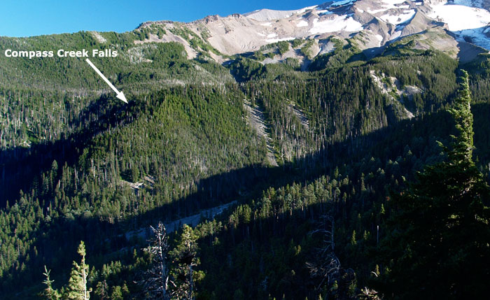
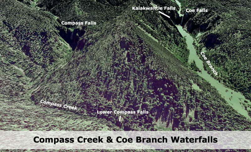
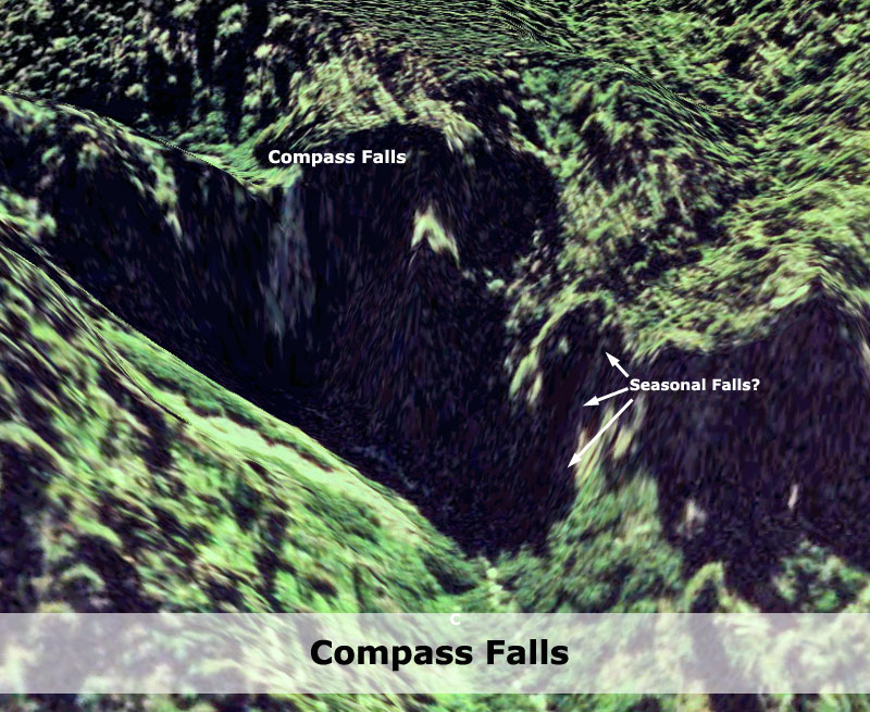
There are 2 more falls in the area located on Compass Creek that would be fun to explore, but what a bushwhack to get into this area. Studying the TOPO map I believe my route, although not perfect, is the shortest way into this canyon. Exploring all 4 falls shown on the map would be better with an overnight bivy perhaps. Another day...

dashed red: GPS tracks
solid red: trail 631
Dashed Yellow: original routes
route.jpg
lightweight, cheap, strong... pick 2

User avatar
AlexanderSupertramp
Posts: 1447
Joined: May 28th, 2008, 10:02 pm

Re: Coe Falls 7/31/2010

Post by AlexanderSupertramp » August 1st, 2010, 10:03 am

Great report Koda. Even with the bad lighting, the falls look pretty awesome, well done. Tom (Splintercat) is gonna like this quite a bit :D

User avatar
Splintercat
Posts: 8334
Joined: May 28th, 2008, 10:03 pm
Location: Portland
Contact:

Re: Coe Falls 7/31/2010

Post by Splintercat » August 1st, 2010, 3:32 pm

That's an understatement, Adam..! :lol: GREAT report, Koda! Both falls exceeded my expectations in the close-up views. The rock is surprisingly solid and intact, albeit scoured by the rugged cycle of winter floods we've had over the past 15 years (the debris fans adjacent to both falls look like they've lost a good 15-25 feet of materials in the flood events -- notable as the light area along the cliff abutment near Coe Falls). That's good -- some of the very tall waterfalls on the glacial outlets are over fairly rotten debris deposits and doomed to collapse at some point. This pair looks very solid. Kalakwahtie Falls is quite graceful -- a future Ramona Falls in the making?

The small unmapped stream sure looks promising -- plenty of flow, and it doesn't look seasonal, either.

Thanks for the report! Lots of Mount Hood-area waterfalls getting checked off the "close-up documentation" list this year -- this pair, Andy's winter trip to Polallie Falls, Devil Canyon Falls and Brian's trip to Hideaway Falls... I'm probably missing some, too!

-Tom :)

User avatar
Koda
Posts: 3466
Joined: June 5th, 2009, 7:54 am

Re: Coe Falls 7/31/2010

Post by Koda » August 3rd, 2010, 10:23 pm

Now my curiosity turns to the 2 falls on Compass Creek. But there is just no easy way into that canyon. It's not difficult route finding per se'... just the brush was so thick. I didn't think about it last weekend, but I wonder if one could get a zoom view of the lower falls on Compass Creek from the viewpoint on 631. looks like a direct line of sight. I have a hunch the most upstream falls could be as big as Coe. Would make for a long exhausting day trip....
lightweight, cheap, strong... pick 2

User avatar
Splintercat
Posts: 8334
Joined: May 28th, 2008, 10:03 pm
Location: Portland
Contact:

Re: Coe Falls 7/31/2010

Post by Splintercat » August 3rd, 2010, 10:43 pm

Good question -- I don't remember seeing the lower falls from there, but also couldn't find any photos where the falls location isn't blocked by trees, or just outside the view. You can definitely see the top of the main (middle) Compass Creek Falls cliff complex from the viewpoint, however. The trick is recognizing that the ridge that forms the east wall of the upper Coe canyon is actually more of a shelf, so the top of Compass Creek Falls is only a couple hundred feet lower in elevation than the crest of the canyon wall/ridge. You can definitely see the rocky notch where the creek pours off the shelf, and that gives some indication of just how large it is. Here's a clip from the Coe viewpoint:

Image

Rugged country in there... I'll be waiting for the trail..!

:)

User avatar
Koda
Posts: 3466
Joined: June 5th, 2009, 7:54 am

Re: Coe Falls 7/31/2010

Post by Koda » August 3rd, 2010, 11:15 pm

Google Earth gives me enough evidence to say that the upper Compass Creek falls is every bit as large as Coe Falls. Here is a screenshot of them side by side.
compass and coe falls GE - Copy.jpg
and here is a closeup of Compass Falls.
compass falls GE.jpg
(I can't figure out why Google Earth's image around Mt Hood is so... BAD. while the rest of the region is descent imagery. I don't remember it being that way, its almost useless. )

It's just a little hike in there Tom... come on now :)
lightweight, cheap, strong... pick 2

User avatar
Splintercat
Posts: 8334
Joined: May 28th, 2008, 10:03 pm
Location: Portland
Contact:

Re: Coe Falls 7/31/2010

Post by Splintercat » August 4th, 2010, 10:25 am

:lol: :lol: :lol:

You know, the headwaters set is more within my physical reach, but I've been (semi-patiently) waiting until the Eliot Branch crossing is restored before exploring that area. Here's all of my beta on this area:

View of the two mapped waterfalls on Compass Creek in relation to Coe Falls:

Image

The lower falls looks like a 25-40 footer, and the fact that it was even mapped suggests that there was some foot traffic here at some point. I think Bryan Swan is right about the old mystery photo of "Wallalute Falls" being the large falls on Compass Creek.

Here's a view of Compass Falls, but what I've mostly been intrigued by is the possibility of a seasonal (maybe year-round) tributary that also seems to drop over this escarpment from the west. It's a tiny watershed, but high enough that it would have snowmelt/groundwater runnoff well into the summer, if not longer:

Image

So, kind of like Coe (or Multnomah) in possibly having a little companion falls...? That would be cool.

Here's a schematic of the headwaters area, where there are at least six waterfalls, three each on the east and west forks (oddly, the middle fork doesn't appear to have any):

Image

This is really accessible from the Timberline Trail, and photos of the two falls located above the trail are common, as are photos of the middle and brink of the lower falls on the west branch. But they'd make for a fun trip to get some decent photos and document them close up. This terrain would be similar to some of the bushwhacking I did over in the Clark Canyon area, which is pretty brushy -- a tangle of huckleberries, mountain ash and rocky terrain underneath, but easy to navigate visually.

BTW, agreed on the horrible Hood imagery, but there's a fix: in Google Earth go to View, then turn on "Historical Imagery". That will put a clock face icon in your toolbar, and selected it will put a floating slider that allows you to pick archival air photos to view for a given area. That's how I work around the crappy Mount Hood imagery that appeared sometime last year. June 6, 2009 seems to be the last decent set for Mount Hood, but at least Google keeps the old photos around, so that we have a choice. In the future, this will become very handy as a few years of higher-resolution images begins to accumulate, and allow for convenient research.

-Tom :)

User avatar
jaimito
Posts: 850
Joined: May 28th, 2008, 10:03 pm
Location: Kenton
Contact:

Re: Coe Falls 7/31/2010

Post by jaimito » August 4th, 2010, 10:47 am

Very cool, good job! I knew it was doable, I'm jealous you got in there before me!! We've all been discussing this one on and offline. Everything has been put on hold for me this summer do to a recent neck surgery - O well.

Cheers

User avatar
jeffstatt
Posts: 3820
Joined: May 28th, 2008, 10:03 pm
Location: Vancouver

Re: Coe Falls 7/31/2010

Post by jeffstatt » August 4th, 2010, 10:54 am

Great report. And dude - no reason to apologize for the photos! It's a treasure hunt and you just found a pot a gold! Don't worry if it's a bit dusty!

And one more thing - It must be repeated Google Earth may possiby be the greatest invention for hikers since the titanium spork

User avatar
Koda
Posts: 3466
Joined: June 5th, 2009, 7:54 am

Re: Coe Falls 7/31/2010

Post by Koda » August 4th, 2010, 6:29 pm

excellent beta on this area Tom. And your tip with GE works great, thanks for sharing I can actually use GE again for the Mt. Hood area.

So I have my eye on Compass Falls now. But that one isn't going to be so easy to get to. From your GE screenshot, it looks like hiking up the creek is more bushwhacking as opposed to the open rock hopping on Coe Creek. I'm also curious about the abandoned forest road 630 that pokes into the canyon about 1.7 miles, that might be a more direct approach if its hikable? It's entrance is gated at FR 2480. But if its really overgrown I think the 631 trail is faster to hike on. I'm curious how long it has been gated off?

all the pics are here:
http://picasaweb.google.com/wayneaharvey/CoeFalls#
lightweight, cheap, strong... pick 2

Post Reply