Solving the Clear Branch Rim Mystery (Trail 632)

Discussions and Trip Reports for off-trail adventures and rediscovering lost trails
Post Reply
User avatar
Splintercat
Posts: 8334
Joined: May 28th, 2008, 10:03 pm
Location: Portland
Contact:

Solving the Clear Branch Rim Mystery (Trail 632)

Post by Splintercat » July 2nd, 2010, 9:05 am

Several years ago, I picked up a KML of trails in the MHNF, and one that jumped out to me was a route that climbed the steep moraine above Laurance Lake and the Clear Branch, north of Mount Hood. I call this feature Clear Branch Rim, for lack of a formal name. Here's the vicinity:

Image

The trail interested me because (as you can see on the map) the Owl Point/Red Hill area is just to the east, and I'm interested in an alternate trail access to this area, and especially one that might be open in winter. But there were also some really weird trails on the KML that just didn't exist -- then I lost the KML completely in the process of upgrading computers a couple years ago.

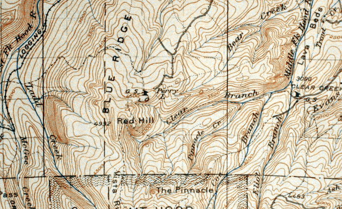
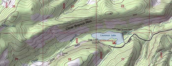
So, this info was in the back of my mind when I picked up the new National Geographic maps to Mount Hood and the Columbia River Gorge last year. To my surprise, the Clear Branch Rim trail was shown, and given a trail number! The alignment was similar to what I'd seen on the KML, and this told me that the trail data on the NG maps had been pulled from USFS trail shapefiles, at least as a starting point -- though some of the oddball KML routes that definitely didn't exist were dropped from the NG maps. Very interesting! Here's a clip of the NG map in question:

Image

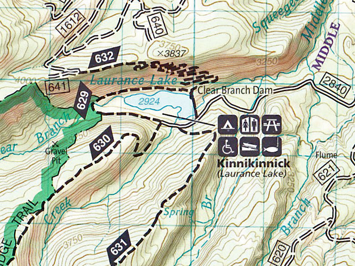
So, this suggested some sort of ground-truthing or confirmation on the route. More recently, I was plowing through some USFS planning maps, and came across ANOTHER reference to this trail -- clearly using he same shapefiles that the NG maps had used, and applying the same trail numbers. Now I was VERY intrigued by the possibility of a trail existing here, at least administratively (which is half the battle). Here's the USFS version:

Image

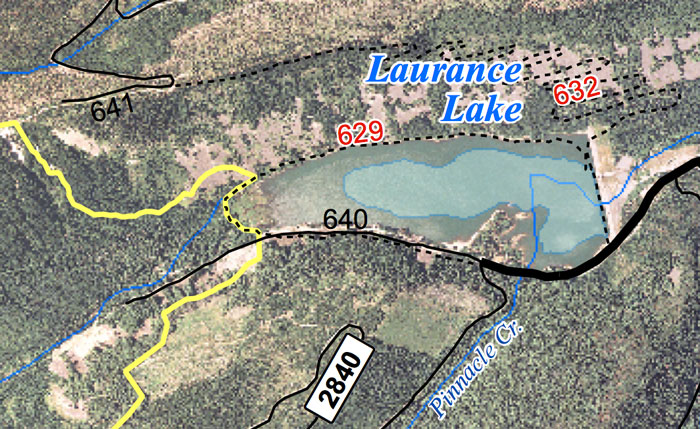
But I had looked at this slope from below, in the field, and on various generations of aerial photography, and it just didn't seem to be there -- so I had chalked it up to being a "planned" trail of some sort, and that wouldn't be bad. It would just mean building a trail from scratch across a huge talus slope -- but at least it was a recognized part of the system.

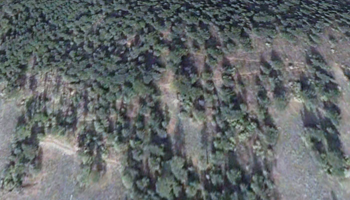
Then I was doing more research on this area a few weeks ago, and happened to be looking at the moraine just downstream from the lake, when I spotted what is CLEARLY a trail or road in a semi-wooded section of the moraine slope, thanks to winter photography from 2005. Using this info, I've sketched in the portions of the route that are clearly visible on the following clip:

Image

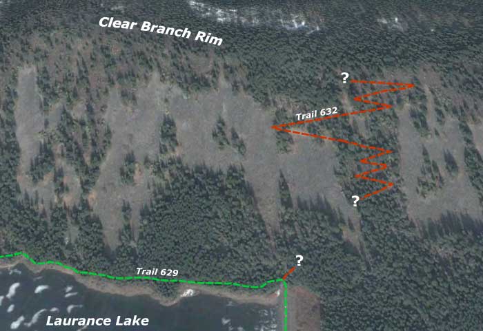
This helps untangle some of the mystery, since this alignment heads straight up the slope in fairly short switchbacks, where the map data suggests a route that meanders west, and reached the top of Clear Branch Rim some distance to the west of where the air photo route seems to go.

So... more field work is in order! There would still be some big gaps in connecting to Owl Point and the Old Vista Ridge Trail, but this would get you past the worst part. I'll report more as new info emerges...

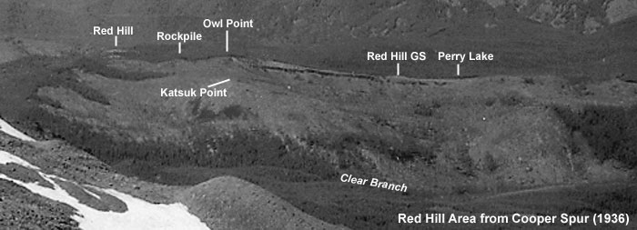
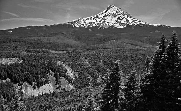
One last image, from years ago (back in the days of film!), sometime in the 1990s, when I explored the top of the rim -- to give an idea of the views that open up as you climb the moraine:

Image

The Clear Branch has had pretty rough treatment over the years -- heavily logged, dammed -- but is one of the more spectacular corners of the mountain, and deserves to be appreciated by a few more visitors...

Tom :)

pablo
Posts: 1451
Joined: May 28th, 2008, 10:03 pm

Re: Solving the Clear Branch Rim Mystery (Trail 632)

Post by pablo » July 2nd, 2010, 10:09 am

Tom,

Neat find, I've been wanting to get out that way to check out your Owl Point stuff and hike some of the trails in the area. In the '38 map shows good trail on the north side of Clear Creek, think there is anything there now? Also on the '38 map there is a trail going up out of Clear Creek to Red Hill that would be fun.

--Paul
The future's uncertain and the end is always near.

User avatar
Charley
Posts: 1839
Joined: May 28th, 2008, 10:03 pm
Location: Milwaukie

Re: Solving the Clear Branch Rim Mystery (Trail 632)

Post by Charley » July 2nd, 2010, 10:34 am

KML?
Kung-Fu Master License?
King Martin Lassiter?
Kraft mit Lager?
Believe it or not, I barely ever ride a mountain bike.

User avatar
vibramhead
Posts: 810
Joined: November 15th, 2009, 10:52 am
Location: SW Portland

Re: Solving the Clear Branch Rim Mystery (Trail 632)

Post by vibramhead » July 2nd, 2010, 11:12 am

KML = Keyhole Markup Language, i.e., Google Earth compatible. Keyhole was the predecessor to GE.
Time spent hiking will not be deducted from your life.

GPS tracks on Wikiloc.

User avatar
jaimito
Posts: 850
Joined: May 28th, 2008, 10:03 pm
Location: Kenton
Contact:

Re: Solving the Clear Branch Rim Mystery (Trail 632)

Post by jaimito » July 2nd, 2010, 12:36 pm

cool Tom when do we start work?

User avatar
Don Nelsen
Posts: 4382
Joined: May 28th, 2008, 10:03 pm
Location: Vancouver, WA

Re: Solving the Clear Branch Rim Mystery (Trail 632)

Post by Don Nelsen » July 2nd, 2010, 12:44 pm

Tom, wow! neat find and great research. Not an area I've spent any time in but looks like I will.

dn
"Everything works in the planning stage" - Kelly

"If you don't do it this year, you will be one year older when you do" - Warren Miller

User avatar
Splintercat
Posts: 8334
Joined: May 28th, 2008, 10:03 pm
Location: Portland
Contact:

Re: Solving the Clear Branch Rim Mystery (Trail 632)

Post by Splintercat » July 2nd, 2010, 1:01 pm

Hi Paul -- yes, there's a lot of intriguing stuff on that map... but first, a view of the switchbacks above Laurance Lake without my mark-ups:

Image

Very prominent, and they kind of look like they've been used!

Back to the 1938 map, this one has me somewhat perplexed -- the "major" trail heading up the Clear Branch has no visible traces on Katsuk Point, for example (labled as "Red Hill" on the map, although Red Hill is actually between the B and L in "Blue Ridge"). Here's a map clip:

Image

This map also shows a trail going over the shoulder of Owl Point (due north of the"e" in Red Hill), and I don't think that's the case -- I've walked that area pretty extensively, with no sign of a trail. Of course, the area was mostly a burn back when this map was prepared. Here's a vicinity photo from Cooper Spur taken in 1936 -- almost entirely burned off, and the burn continues all the way east along the face of the Clear Branch Rim until the ridge ends near the lava flow:

Image

-Tom

User avatar
Splintercat
Posts: 8334
Joined: May 28th, 2008, 10:03 pm
Location: Portland
Contact:

u

Post by Splintercat » July 2nd, 2010, 1:10 pm

"...cool Tom when do we start work?"

:lol: :lol: :lol: :lol:

Don, the area around Perry Lake is artifact country -- the footings & foundations for the old lookout, guard station and outbuildings are all still there, and there's various stuff along the road leading in from the northeast. I'm really not sure of the history of the GS, but it was clearly located here for the access to Perry Lake (for water) and the sweeping view across the north face of the mountain, of course. The other interesting aspect is the rail line coming up the West Fork valley. Part of the old rail grade is paved road, now, and there are other sections that are gravel road or simply abandoned. Quite an ambition grade when it was constructed!

Tom

Post Reply