Trail Trace on Shellrock Mountain (Columbia Gorge)

Discussions and Trip Reports for off-trail adventures and rediscovering lost trails
User avatar
Splintercat
Posts: 8333
Joined: May 28th, 2008, 10:03 pm
Location: Portland
Contact:

Trail Trace on Shellrock Mountain (Columbia Gorge)

Post by Splintercat » May 22nd, 2009, 11:04 pm

Has anyone walked this trail across the upper scree slopes of Shellrock Mountain? Seems to be tied to the powerlines, but I'm wondering where it goes on either end. It's well upslope from the "military road" or "wagon road" that can be seen from the freeway:

Image

Anyone have recent history with this trail?

Tom

pablo
Posts: 1451
Joined: May 28th, 2008, 10:03 pm

Re: Trail Trace on Shellrock Mountain (Columbia Gorge)

Post by pablo » May 23rd, 2009, 10:32 am

That looks like a trail in passable shape.

At the end of a Shellrock TR I did, mandrake provided some words about the powerline trail:
The Shellrock ridge is quite doable as a loop out of Wyeth -- although I don't recommend following the powerline trail which traverses right across the rockfields around the base of Shellrock. The old powerline trail is has a couple of metal ladders along the way for maintenance workers to get up and down rock bands which are interesting, but is also wiped out in sections by rock slides & extremely loose[...]
Exploration of this powerline route is on my list for this summer - looks like a possible way of extending the 400. Just follow the powerline road out of Wyeth and drop down to the wagon road after a while then traverse over to Defiance trail. Maybe follow that road on the east side of Lindsey Creek.
shellrockpowerline.JPG
The future's uncertain and the end is always near.

User avatar
chameleon
Posts: 1795
Joined: May 28th, 2008, 10:03 pm
Location: Oregon
Contact:

Re: Trail Trace on Shellrock Mountain (Columbia Gorge)

Post by chameleon » May 23rd, 2009, 12:02 pm

Tom,
Don did a wonderful map that he posted on my recent Lindsey Creek thread of the trails, etc...running up Shellrock Mtn. He seems to have a lot of knowledge of that area. It is really a fascinating trail/road system up it. Check out that thread - I'm not sure of how to post a link as others often do. But it was a very good map, I believe he created with the assistance of his GPS.
-Zach

User avatar
Splintercat
Posts: 8333
Joined: May 28th, 2008, 10:03 pm
Location: Portland
Contact:

Re: Trail Trace on Shellrock Mountain (Columbia Gorge)

Post by Splintercat » May 23rd, 2009, 1:27 pm

Paul, you read my mind. I was scouting around the area a couple weeks ago, and photographed the mountain from the end of the old highway section that heads east from the interchange. There's a utility building there (looks like phone) and I suppose this will someday be part of the restored scenic highway. But it was make a much superior trailhead to the obscure one tucked in the back of the campground -- plus, it wouldn't have to be locked in winter.

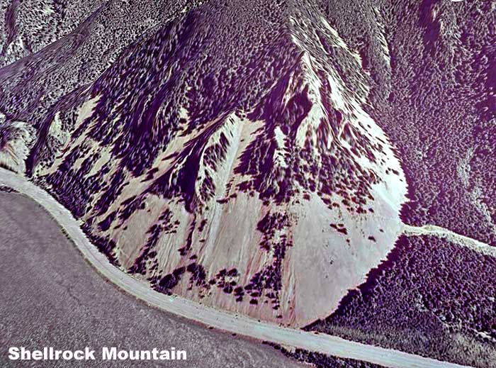
Here's a GoogleEarth view (cleaned up from their crappy new State of Oregon imagery) of Shellrock -- you can see the west end of the powerline trail, to some extent:

Image

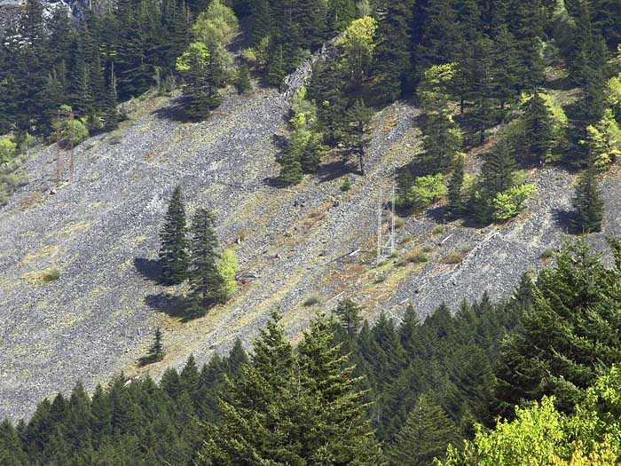
And here's a close-up view of the trail on the northeastern flank that I think you took last year:

Image

I'm interested in both the Trail 400 possibilities, but also in a 4-mile round trip hike from this conceptual trailhead to the top of the rocky northern spur of Shellrock -- here's a sketch of the concept:

Image

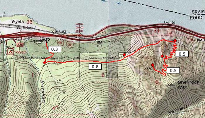
This would be sort of an Angels Rest, with a traverse then switchbacks to a viewpoint. The conceptual trailhead has the added advantage of giving a good view of the destination:

Image

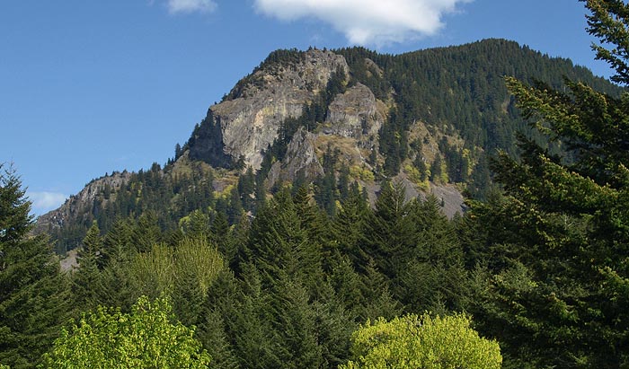
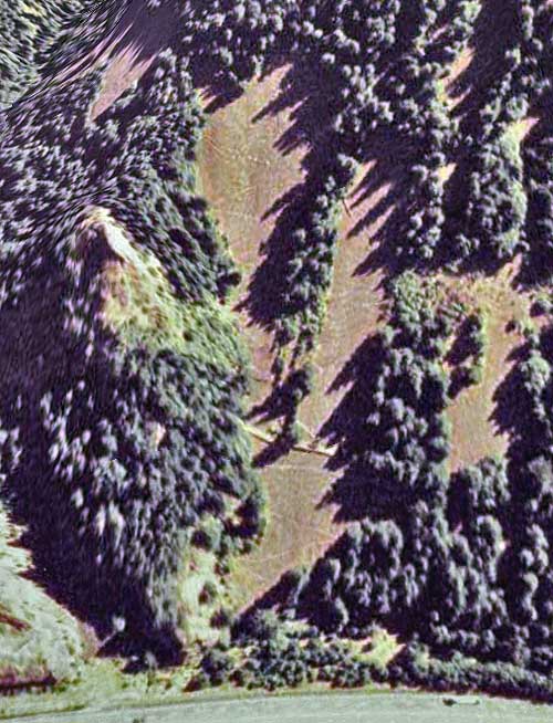
Looks like more than 1,700 feet! Here's a close-up of the northern spur, where I'm hoping there is an actual viewpoint that would make all of this a meaningful concept to pursue:

Image

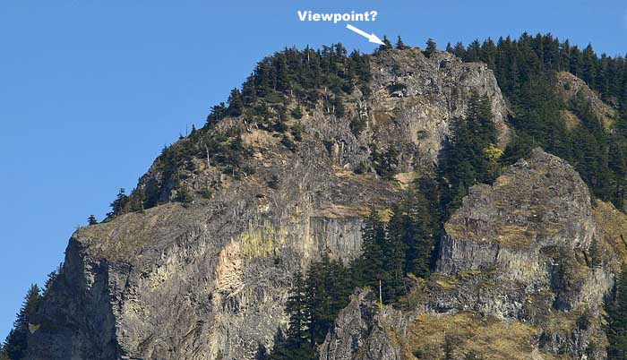
In Doug Lorain's Afoot & Afield, he describes a brush bushwhack to a viewless "summit" in his Shellrock Description, but I'm fairly certain that he's describing the true summit, since he describes it as 800 feet higher than the USGS platform where the trail ends (at 1,300 feet). With the northern summit spur topping out at 1,770 feet, it's more like 400 feet higher than the USGS platform.

BTW, the thing that has always intrigued me about Shellrock are the enormous tilted basalt tables below the northern summit spur -- massive! I don't know the geology, but these have either been tilted in a syncline, or possibly the entire shelf is tilting from erosion by the river. The Missoula floods did a real number on both Shellrock and Wind Mountain, across the way. So it's possible that this is a huge mass that will someday slide and make I-84 rather irrelevant..!

Tom

User avatar
Splintercat
Posts: 8333
Joined: May 28th, 2008, 10:03 pm
Location: Portland
Contact:

Re: Trail Trace on Shellrock Mountain (Columbia Gorge)

Post by Splintercat » May 23rd, 2009, 1:29 pm

Thanks, Zach - posted on top of you there. I'll check that out!

Tom

User avatar
chameleon
Posts: 1795
Joined: May 28th, 2008, 10:03 pm
Location: Oregon
Contact:

Re: Trail Trace on Shellrock Mountain (Columbia Gorge)

Post by chameleon » May 23rd, 2009, 4:48 pm

Here is the map Don created of the shellrock road/trail he followed to the top. I was able to cut and save it from the Lindsey Creek thread. He has a good description on there too if you want to read about it.
-Zach
orig.jpg

mandrake
Posts: 389
Joined: May 28th, 2008, 10:03 pm
Location: Portland, OR

Re: Trail Trace on Shellrock Mountain (Columbia Gorge)

Post by mandrake » May 24th, 2009, 4:39 pm

I've hiked the Shellrock traverse trail from Wyeth previously -- it's an access trail used by workers to get at the powerlines and it's in pretty bad shape. I would not recommend it to the casual hiker. Lots of loose rock underfoot which makes for slow going and the trail has been knocked out in sections by rockslides coming down from higher up on Shellrock over the years. I found a dead deer just adjacent to the access trail in crossing which probably says something about the quality/stability of the area. Did I mention the poison oak? There are two 20' rockbands to descend heading eastbound and the powerline workers have installed metal ladders for ease of access. There is one short slightly exposed section with a metal cable anchored into the rockface for a handline. (All seemed reasonably stable/safe, but I wouldn't recommend a trip here just to see them.) There used to be 1-2 other access trails for workers coming up from below -- remnants of the switchbacks can be seen in the talus.

The powerline trail eventually intersects the "main Shellrock Mtn trail" described in Douglas Loraine's book -- but it is washed out and impassable just east of the rock formation known as "The Backbone". A relatively recent washout took out the trail; sheer drop down to Summit Creek presently. (To get over to Lindsey Creek, either drop down to I-84 and cross Summit Creek at the hwy -- or thrash your way up and over the Backbone.)

If you want to get over there from Wyeth it's a lot faster (and probably safer) to drop down to the base of the rockfield and hike east along I-84 until you scramble up to the remnants of the old wagon road. (This is not an entirely poison oak free option, however.)

User avatar
4DMTNS
Posts: 158
Joined: September 26th, 2010, 7:05 pm
Location: Portland

Re: Trail Trace on Shellrock Mountain (Columbia Gorge)

Post by 4DMTNS » July 26th, 2011, 6:01 am

Thanks to all who posted here with such great, detailed posts about Shellrock Mtn. I was thinking about checking it out today ... think I'll do more research first AND bring a hiking buddy.
I'm almost always the sweep on my hikes ... it gives me an opportunity to taste test all the edible berries I seem to find.

Where's Chris?
Instagram WhereIsChrisNow

User avatar
geographics
Posts: 963
Joined: August 5th, 2010, 2:11 pm

Re: Trail Trace on Shellrock Mountain (Columbia Gorge)

Post by geographics » July 26th, 2011, 9:00 am

.
Last edited by geographics on February 23rd, 2012, 9:53 pm, edited 1 time in total.

mandrake
Posts: 389
Joined: May 28th, 2008, 10:03 pm
Location: Portland, OR

Re: Trail Trace on Shellrock Mountain (Columbia Gorge)

Post by mandrake » July 26th, 2011, 9:13 am

To clarify my previous post: I wouldn't recommend walking along the shoulder of I-84 at all to get around Shellrock; serious risk of getting pancaked by a semi. Erk. Much better to be on the Shellrock side of the concrete barrier. The going there is relatively easy. When vegetation begins to block your way heading eastward, cut up through the scree a short distance and get on the old wagon road. You can then follow this & user paths east over to the "main" Shellrock trail. Much safer and more interesting despite the occasional patch of poison oak to navigate around.

Post Reply