
My hike was in two parts: I’ll call them West Sevenmile Hill and Rowena Dell. I parked at the Rowena Crest Viewpoint and headed up the Tom McCall Point Trail, looking across at the slopes of Sevenmile Hill as I went up trying to get a feel for the geography.
Memaloose to Sevenmile Hill: Joining the dots
Memaloose to Sevenmile Hill: Joining the dots
I returned to the east Gorge last Sunday to explore more a hiking route that could lead from Memaloose State Park to the bottom of Sevenmile Hill. Among other things, it was an immersion course in poison oak, but I appear to have survived unblemished. Although many of the routes/trails around here are obvious if you know where to start, I am posting on this forum because the public/private property lines are convoluted and need to be respected.
My hike was in two parts: I’ll call them West Sevenmile Hill and Rowena Dell. I parked at the Rowena Crest Viewpoint and headed up the Tom McCall Point Trail, looking across at the slopes of Sevenmile Hill as I went up trying to get a feel for the geography.
From the top of McCall Point, I dropped down to a grassy saddle. You can head right (west) down from the saddle on an old jeep track to make a loop around the base of McCall Point. This time, I continued on the obvious trail up into the woods along the ridge of Sevenmile Hill. The trail here keeps more or less to the edge, with some panoramas looking north to Mt. Adams, Lyle, etc., but more often than not heading through meadows and oak woods. There’s a spot on the edge with some plywood boards, like jump-off platforms: I think I have seen paragliders take off from here before.
A fence runs to the right of the trail. However, I saw property line flagging and national forest markers to the left of the trail just a few yards downslope. It would be much harder to bushwhack inside this line and it looks like hiking the trail where it is has been tolerated. Eventually, the trail reaches a fence just beyond a roadbed coming up the north slope of Sevenmile Hill and turns down it. I didn’t want to cross the fence, so I turned down the road bed into Douglas-fir woods. There’s a human trail down this track. Where the Douglas-firs transition into oaks, an overgrown spur leads right and east.
Since that’s the direction I wanted to go, I followed it. I don’t think this track is regularly used at all and may last have been used a few years ago during a USFS debris-clearing operation (There are small fire circles every few yards). The track is level and then rises into the Douglas-fir forest again. I followed a short burst of flagging into a thicket of hazel and snowberry and then crossed a steep-sided draw. This led me to an open, grassy slope lined by oaks. I headed up again to the crest. The fenceline there was in disrepair and I stepped over it to land in a flat farmer’s field of stubble. I went back down again and saw that the only option on public land was to keep to the brushy Douglas-fir woods just below the crest. I decided to explore this at a later time and headed down the open slope, ate lunch, recrossed the steep draw lower down, then headed up in oak meadows to rejoin the human path on the jeep trail.
This track is clearly visible to anyone at Rowena Crest. It switchbacks down, going in and out of woodland. At one point, a connector trail goes off to the left and rises up to the Sevenmile Crest. I continued down and came to another junction at a fire pit. I believe the main road track continues down to the highway. I went left here and made a traverse below the talus slopes of the steep east face of McCall Point, across a rock slide and then took a cliffside trail with lots of deer tracks to join the McCall Point Trail at its first switchback.
The land I was on was either Nature Conservancy, Mayer State Park land or USFS. There weren’t any No Trespassing signs along the fencelines, but it is expedient to keep to existing trails or, when going cross-country, keep below the private property line on Sevenmile Hill. Next spring, I will return and do Sevenmile from The Dalles side and figure that last mile or so of the route that I missed.
Last edited by bobcat on June 7th, 2012, 2:11 pm, edited 2 times in total.
Re: Memaloose to Sevenmile Hill: Joining the dots
And here's the report on the Rowena Dell Loop:
From the base of Tom McCall Point, a grassy trail leads west below rimrock to Highway 30. You go left on the highway for about 200 yards to a pullout. There’s a Nature Conservancy sign on a fence here. I went through the fence and walked through the grass parallel to the highway until I reached a road bed. The road bed takes you up to the wide, grassy bench on the west side of McCall Point. From here, I walked across the fields to the USFS boundary line, marked by a fence. To the right was a telephone pole with a No Trespassing sign at a fenced field, the only such sign I saw the whole hike.
I keep walking in the open fields, with McCall Point to my left and an oak-forested branch of Rowena Creek to my right. I reached a spring area with fencing around it and headed right across open fields to the main branch of Rowena Creek. Here I had to figure a way down through the poison oak. The paths of least resistance were the deer trails. I crossed two dry stream beds and headed up on the grassier north bank. There I encountered a trail that someone is definitely manufacturing through this area. I followed it up to the north rim of the ravine and then crossed a grassy sward to the gravel Dell Road. I went right on Dell Road and followed it down to the highway, turned right, and then made a left onto a gravel track.
Past an iconic barn, a trail leads to the west rim of Rowena Dell. Also beyond the barn, a sign denotes that the gravel track is a Private Driveway, but I think this is to discourage vehicles rather than walkers, because the driveway is on USFS land most of the way down. The trail along the rim has been recently mowed. This sliver of land is listed as belonging to the Rowena Dell Homeowner’s Association, but it seems open to all and there are no signs. At some point, there is a neo-Paleolithic circle of stones ("neo" because I don’t remember it being there before). The track reaches a gap in a fence, crossing onto the USFS property. Then it makes a swing to the left and joins the gravel road.
I continued down the rim and looked for a scramble route down. I chose a very steep one. Farther north, there are easier routes. I wandered about the Dell bottom and crossed Rowena Creek. I have always thought of Rowena Dell as Rattlesnake Heaven, but the one below is probably the cutest little viper I have ever seen. He was so tiny, I don’t think he had more than one rattle, and he just had to lie there and hope I wouldn’t do something nasty.
Across the creek bed, I headed a short way down a road bed and found the breach at the far north end of the Rowena Plateau. This short path goes up scree and is marked by cairns. From here, I walked the trails up the plateau to the parking lot.
From the base of Tom McCall Point, a grassy trail leads west below rimrock to Highway 30. You go left on the highway for about 200 yards to a pullout. There’s a Nature Conservancy sign on a fence here. I went through the fence and walked through the grass parallel to the highway until I reached a road bed. The road bed takes you up to the wide, grassy bench on the west side of McCall Point. From here, I walked across the fields to the USFS boundary line, marked by a fence. To the right was a telephone pole with a No Trespassing sign at a fenced field, the only such sign I saw the whole hike.
Last edited by bobcat on June 7th, 2012, 12:34 pm, edited 1 time in total.
Re: Memaloose to Sevenmile Hill: Joining the dots
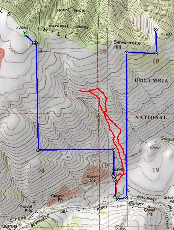
(Sorry, this turned out to be a lengthy report) Here’s my sketch of the routes I have done on this and other trips. Sorry, I don’t have a GPS, so my tracks are rough. They are all within permitted hiking area, however. I would draw in the current boundary lines (expanded from this topo version) but I can’t figure out how to draw straight lines.
Red = established trails, fairly obvious use trails
Black = road sections
Blue = cross-country routes
EDIT: Please see Peabody's post below. The map track shows access to the east slope of Sevenmile Hill via USFS land, a better and more scenic option, rather than Wasco County land as the map above shows.
Black = road sections
Blue = cross-country routes
EDIT: Please see Peabody's post below. The map track shows access to the east slope of Sevenmile Hill via USFS land, a better and more scenic option, rather than Wasco County land as the map above shows.
Last edited by bobcat on June 8th, 2012, 5:34 pm, edited 1 time in total.
Re: Memaloose to Sevenmile Hill: Joining the dots
Thanks for the map and beta, Bobcat! I've done a little exploring in the area and was curious about larger loop possibilities. From the land trust info on the Friends of the Gorge site it appears work is being done towards establishing a trail from the Memaloose rest area over to Rowena Dell roughly parallelling I-84. From their maps it looks like this area is now all public land or in the land trust.
http://www.gorgefriends.org/article.php?id=140
http://www.gorgefriends.org/article.php?id=84
http://www.gorgefriends.org/article.php?id=82
Looks like one could park at the Memaloose overlook, head east to Rowena Dell, up across the plateau, up Tom McCall Pt, then return on a loop via the Memaloose Hills. Great outing for wildflower season!

Re: Memaloose to Sevenmile Hill: Joining the dots
According to Sullivan the boards are the remains of a picnic table.bobcat wrote:There’s a spot on the edge with some plywood boards, like jump-off platforms: I think I have seen paragliders take off from here before.
Thank you very much for the trip report and the map; I look forward to going back for some more exploration.
Some people are really fit at eighty; thankfully I still have many years to get into shape…
Re: Memaloose to Sevenmile Hill: Joining the dots
Hey bobcat,
Great thread and thx for posting more information about this area. I'm going to be wearing my rattlesnake boots when I do this.
I have a Garmin 60csx sitting in a drawer gathering dust (as well as a DeLorme PN40) so if you want to take a GPS along you when you go out hiking this area, you are welcome to it.
--Paul
The future's uncertain and the end is always near.

Re: Memaloose to Sevenmile Hill: Joining the dots
I love that area! At some point I'd like to hike from the SE corner of 7 mile hill to Rowena Plateau. I think that can be done on all public land.
The portion of the track you show on the eastern part of 7 Mile Hill near the gravel pits is private land. Below is a map showing where the public land is in that particular area.
The portion of the track you show on the eastern part of 7 Mile Hill near the gravel pits is private land. Below is a map showing where the public land is in that particular area.
"I arise in the morning torn between a desire to improve the world and a desire to enjoy the world. This makes it hard to plan the day.”
― E.B. White
― E.B. White
Re: Memaloose to Sevenmile Hill: Joining the dots
Yes, the map seems identical with the instructions in Scott Cook's Curious Gorge (3rd edition). There one can also find exact directions to the starting point.Peabody wrote:The portion of the track you show on the eastern part of 7 Mile Hill near the gravel pits is private land. Below is a map showing where the public land is in that particular area.
Some people are really fit at eighty; thankfully I still have many years to get into shape…
Re: Memaloose to Sevenmile Hill: Joining the dots
@pablo: Thanks for the generous offer. I might end up taking advantage of it some day!
@Peabody: Thanks for showing the USFS boundaries on East Sevenmile Hill. However, the gravel pit area is Wasco County (public) land. It is basically an open yard along the creek where they store large equipment and materials. Last time I was there, there were no Keep Out or No Trespassing signs posted and no security whatsoever. I don't know what they feel about people walking through the yard to hike up the hill, but another group was doing it, so we did it too (That was then; I don't know if there is any kind of signage now, so someone who has been there this year might inform).
Anyway, to be sure, if you can pinpoint that sliver of USFS land that hits Sevenmile Road, it would be the best way to access Sevenmile from the east.
The USFS boundary seems to run directly over Point 2050 and then a narrow corridor connects the East Sevenmile parcel to USFS land north of the CRGNSA boundary. The trick would be to pinpoint that connection.
The Wasco County Tax Lot Map shows land ownership in the area.
-
SonOfTamarack
- Posts: 83
- Joined: December 3rd, 2009, 1:28 pm
Re: Memaloose to Sevenmile Hill: Joining the dots
Does anyone know what would need to be done, officially, if one wanted to put in a bench with a dedication plaque on public land on the rim of Sevenmile Hill?