Trailhead:
Benson Bypass
Benson Bypass
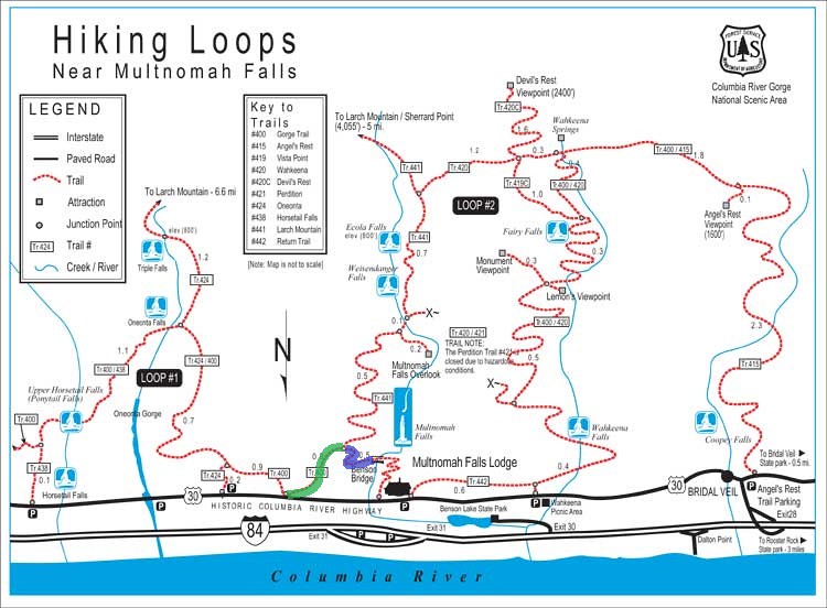
A slide has closed Larch Mtn Trail from the intersection with the 400 to the Benson Bridge. I was not able to a look at the slide, too dark, but the hard rain that fell this evening is not going to improve matters. Here is a route the I'm calling the Benson Bypass - I would not be surprised if this route was used by some during the recent repairs to Benson Bridge. The route is steep, with loose rock and dirt but not a lot of brush or blowdown, no scrambling needed. I figured it took 10-15 minutes from the highway to the 400 landing about 2-300 feet east of the intersection with Larch Mtn Trail (and the trail closed sign). The route starts at the end of the parking spots just east of the bridge across Multnomah Creek. There is a blank sign right next to where a use trail takes off steeply up the hill. Any semblance of trail disappears soon enough. Go east and up, avoid cliffs.
Trailhead:
Approximate route:
Trailhead:
Approximate route:
The future's uncertain and the end is always near.

Re: Benson Bypass
Oh nice, I'll have to give this a go. If the slide's before the intersection with 400, I presume one could also park at the small pullout just east of Multnomah Falls, and take 400 past Elevator Shaft to the Larch Mountain Trail.
-
Eric Peterson

- Posts: 4097
- Joined: May 11th, 2009, 5:39 am
- Location: Oregon
- Contact:
Re: Benson Bypass
Poked around there today while pretending to be a trail runner and there is no slide blocking the actual
trail, just some sliding earth above a section of trail closer to the Benson Bridge which was concern enough
for them to try and close that small section of trail...
trail, just some sliding earth above a section of trail closer to the Benson Bridge which was concern enough
for them to try and close that small section of trail...

Re: Benson Bypass
This is the "official" Benson bypass  , Posted from another thread:
hikerbot wrote:That is correct.miah66 wrote:Ahh i get it. The closure affects the portion in Blue, but you can still take the trail in Green to access upper falls area:
Sound about right?
"The top...is not the top" - Mile...Mile & a Half
Instagram @pdxstrider
Instagram @pdxstrider