Portland Hikers ArchiveReturn to Portland Hikers Archive Lakes Basin - Eagle Cap Wilderness (6/25-27/07) Posted by justpeachy (2007-09-12)
| This is an EXTREMELY late trip report for a trip I took back in June. I had some drama with a crashing hard drive and picture loss the day after we came home, and then the busy summer happened, so I never got around to doing this before. But for anyone else who decides to visit this area so early in the summer like we did, I thought I'd go ahead and post a report.
The Eagle Cap Wilderness in the Wallowa Mountains is one of the most gorgeous places I have ever had the privilege to visit. And the Lakes Basin area in that wilderness is divine. My sister and I had eight days in NE Oregon, and we planned on three nights in the backcountry. Although we tossed around different ideas, we knew we couldn't pass up the scenic lakes. We figured that since we were there so early in the year and it was the middle of the week, we wouldn't run into the legendary crowds that descend on this area in the summer. They told us at the ranger station that we would likely run into snow, but we went for it anyway.
Day 1
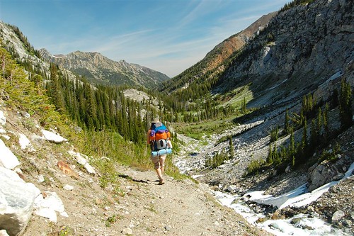
We started from the trailhead at Wallowa Lake. The first six miles of the trail climbs slowly and steadily upwards, paralleling the West Fork Wallowa River, while huge mountains tower above you on all sides.
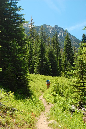
After six miles, we reached - wait for it - Sixmile Meadow. We stretched out on a sunny rock and soaked up the sunshine and the views. It was a gorgeous perfect day. A ground squirrel kept us company out in the meadow, watching us curiously for awhile, scampering around, watching us some more, but never approaching. I would hope that the type of people who make it in this far know better than to feed the wildlife. We did see one other person here, our first -and only - person-sighting of the day back here. He got out his fishing pole and headed down to the river, which borders one side of the meadow.
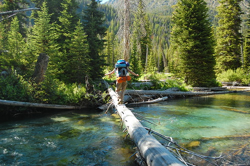
From Sixmile Meadow, the trail continues straight up to Frazier Lake. That would be our return route. We hopped onto the Lakes Basin Trail that would take us a further 3.1 miles up to Horseshoe Lake, where we would camp for the night. This trail immediately has two water crossings, neither of which have bridges anymore, though they once did. We crossed the Wallowa on a long but sturdy log. This is the first time I've had to cross such a wide river on a log, and definitely the first time I've had to do it with a heavy pack. I got a bad case of nerves in the middle of the log, shaking legs and everything. But I made it!
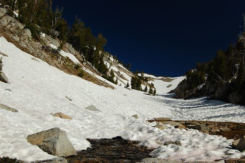
The next crossing, less than a minute later, is across Lake Creek, where the washed-out bridge is still visible. (Talking to the people at the ranger station afterwards, we learned that
these bridges have been out for several years, but that there simply
isn't staff or money to replace them.)
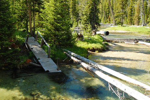
As you can see from the picture, there are PLENTY of logs down across the creek to choose from. And the creek is shallow enough to wade too. We chose a log. And once again I made it across without falling in!
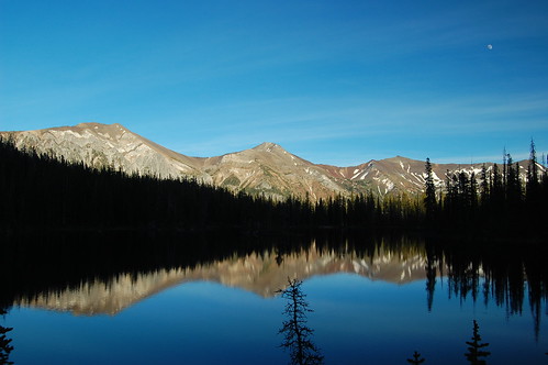
And then began what felt like a really difficult climb up to the lake. It's an 1,100 feet gain in those 3.1 miles, which really isn't bad. But it was the end of the day and my pack was feeling really heavy (and, I'll admit it, I was not in the best of shape). But man, once we arrived at Horseshoe Lake, all that work was SO worth it. We circled around to the west side of the lake where the campsites were. The huge areas of bare ground amongst the trees there was all the evidence we needed that this area is VERY popular. On a Monday evening in June, though, we had the place completely to ourselves. As we set up camp and made dinner, I kept running out of camp to the edge of the lake to see the view. And what a view it was.
It got very cold very fast. The low temps combined with the nearly full moon and the long wait for total darkness meant that we didn't see stars that night. Even with the nearly full moon we still would have seen a ton, but we were too tired and cold to wait up for them. Darkness is a long time coming during these longest days of the year!
Day 2
Tuesday was another gorgeous day with clear blue skies. We hiked on from Horseshoe Lake, passing Lee Lake and Douglas Lake. Somewhere on the trail between Douglas and Moccasin Lakes, we encountered our first snow, at about 7,400 feet.
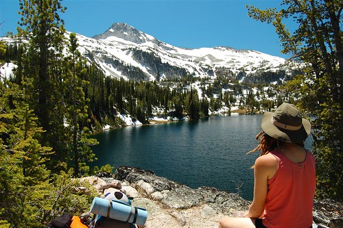
But despite this little bit of the snow, the trail was pretty clear sailing up to Moccasin Lake. We ate lunch on a rock ledge overlooking the lake, with a clear view of Eagle Cap straight ahead. Our original plan had been to camp somewhere in this vicinity on this day and climb Eagle Cap, then go camp at Glacier Lake on our third night. HA! We took one look at all the snow up on Eagle Cap and decided it would be a bad idea to go up there. While eating lunch here, we did see some hikers coming down from there, cutting cross country and sliding down the snow on the mountainside, rather than taking the trail. We actually ran into them the next day and they said the trail up there was pretty well covered in snow for the first part, but that the last part was actually not too bad.
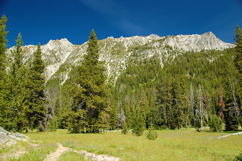
We took a short side trip up to Mirror Lake before continuing on up to Glacier Pass. Mirror Lake is yet another gorgeous alpine lake backdropped by majestic mountains, which were still pretty well covered in snow when we were there, an indication of what we soon faced. We saw a few campers there, as well as a few down at Moccasin Lake. Back down at Moccasin Lake, we crossed the inflow stream on rocks and trekked off toward Glacier Pass. [Begin ominous music here!]
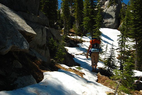
The first little bit after the lake was fine. It got a bit soggy in places, but it wasn't too bad. But soon enough we started encountering more and more snow on the ground. We quickly lost the trail, and knowing we had to cross the creek at some point, we crossed at a spot that looked like where the trail would go. Because the creek was raging with snowmelt, we had to take our boots off and wade. And it turned out that unfortunately, this was not the place where we needed to cross, which we discovered after bushwhacking around for an hour and not finding any trail. So we waded back across and managed to discover where the trail continued upstream, buried in snow.
And so began a brutal and grueling climb. The trail switchbacks a lot here, but since it was all buried under snow, we just went straight up. The melting snow was wet and slippery, and keeping our footing was extremely difficult. Deborah broke trail, bless her. We finally reached the real creek crossing, mostly buried under snow. We filtered some water and pushed on.
We had to climb again, coming out of this creek valley and up to Glacier Pass. More snow to cross. Lots more. My morale plummeted with each slow step. FINALLY, we were on the last push to the pass, and ironically that section was free from snow, even though it was of course higher than all the trail we had just traversed. After 2.7 miles, 4 hours (which included our lost hour when we crossed the creek too soon) and 1,000 feet of elevation gain, we reached Glacier Pass at 6:30 p.m. Oh joy! But then we looked down on the other side of the pass at Glacier Lake and my suspicions were confirmed:
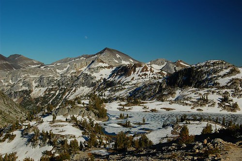
The lake had only barely begun to thaw out and was still mostly covered in ice. The land around the lake was still buried in snow. The outflow from the lake was also under snow. We could hear it raging under there, but we couldn't see it until it emerged from the snow a short ways down. We would not be camping here tonight. I was pretty bummed out. Not only was I exhausted from our snowy climb to the pass, but I had heard how scenic Glacier Lake was, the most photographed lake in the wilderness. We learned from the ranger station later that this lake is one of the last to thaw out in summer.
So we pushed on to Frazier Lake, down the valley two miles. We could see the trail clinging to the valley wall further down, but to get there we first had to make our way down a steep snowy slope. According to the map, the trail wrapped around down along the lake, but we just made our way straight down, completely bypassing the frozen lake. Eventually we broke free of the snow and hit dry trail. As we lost elevation, we started to see a few wildflowers here and there. During the course of the two hours it took to travel the two miles from Glacier Pass to Frazier Lake, we went from winter to summer, just like that. At Frazier Lake, we pitched the tent and made dinner quickly, then fell into bed exhausted.
Day 3
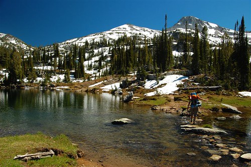
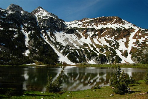
Wednesday morning we woke to more blue skies and warm sunshine. The snowy mountains seemed to rise right out of Frazier Lake.
The morning was beautiful, but the mosquitoes were out. It was the first time we encountered significant mosquitoes on this trip. We later read that this lake is particularly notorious for the little bastards. So we ate breakfast, broke camp, and headed out.
The trail follows the West Fork Wallowa River down to Sixmile Meadow, where we had headed off to the Lakes Basin two days before. We could see down the length of the valley, at the end of which lay our car and Wallowa Lake.
You have to ford the river at some point, which was slightly scary. It was raging with freezing cold snowmelt. I'm pretty short (5'3"), so the swift water soaked me to my upper thighs. I imagine that later in the summer it's not so bad, though.
After the river crossing, the trail just continues its slow descent out of the long valley. It's 10.1 miles from Frazier Lake to the trailhead. We saw quite a few wildflowers along this stretch of trail, which was fun. The lens on my camera started acting up, and my tiredness increased with each step, so my picture-taking rapidly decreased. The last mile of the trail, I was really dragging. I was really happy to see our car waiting for us at the trailhead! We splurged that night and paid to camp at the state park (hot showers!). We had beer and pizza in Joseph and slept like logs that night.
This was a GREAT trip. Deborah's pretty experienced, but It was my first "real" backpacking trip. I'm not a fan of walking around with 35 pounds on my back (who is?), but being able to experience parts of the backcountry that you can't see by day hiking was SO worth it. I'm hooked! Now I just need to get in better shape.
If you do this trip in late June, be prepared for snow. We actually got lucky. The snowpack was pretty low this year; otherwise we would have encountered more snow and at a lower elevation. While the snow is a disadvantage for a late June trip, we were early enough that we beat the worst of the mosquitoes. Even the ones at Frazier Lake weren't as bad as some I've encountered. And we beat the crowds (it also helped being there during the week). This area is really beautiful, and I already can't wait to go back and explore more of the wilderness.
| Re: Lakes Basin - Eagle Cap Wilderness (6/25-27/07) Posted by Grannyhiker (2007-09-12)
| Great report! I wish I could have gotten there this year, but my bum knee has been acting up just enough to curtail any but overnight trips.
35 lbs. is pretty heavy! My pack weight for a week's trip is 24-25 lbs. If you're interested in lightening up, this site was of invaluable help to me--both the articles on the home page (particularly the "27-Lb., 7-Day Pack List") and the excellent forum. | Re: Lakes Basin - Eagle Cap Wilderness (6/25-27/07) Posted by hikingrandma (2007-09-12)
| Great trip report, Peachy! A couple years ago I spent a week
camping at Six Mile Meadow with the Trails Club. We did day
hikes, one of which was the reverse of what you did. It was a
grueling 17 mile day hike but the country is so beautiful, it was worth
every mile. This was in early August and all the snow was
gone. I remember thinking that I was very grateful we weren't
doing the hike in the other direction because it was really, really
steep. Can't imagine doing it through snow. The river
crossing is much easier in the late summer also. We did it
several times (on different hikes) and it was quite easy. That
was the same week we did Polaris Pass and swore that was the "last damn
fool thing" we'd do on that trip. Not sure it was. I had
taken a lot of photos and had never gotten around to backing them up on
CD's and guess what!! Yep! my computer crashed and those photos
were amon the ones I lost. Guess I'll just have to go back and do
the trip again.
| Re: Lakes Basin - Eagle Cap Wilderness (6/25-27/07) Posted by sparklehorse (2007-09-13)
| Nice report and pics Peachy, thanks. Sounds like you had quite the adventure! That is a beautiful area, in fact I think the Wallowas are just about the prettiest mountains to be found anywhere in the state. I've never hiked in to Eagle Cap in June but I did do a trip in early July one year and got eaten alive by skeeters. All my trips since then have been in August when the high passes are mostly free of snow and the bugs aren't too pesky. The Lakes Basin can be busy in August but it is a huge wilderness area and generally it's not that busy outside of the Lakes Basin area. And there are many other areas that are just as pretty.
G |
Return to Portland Hikers Archive
Disclaimer:
Information found on PortlandHikers.org and PortlandHikersFieldGuide.org is
provided by website visitors and volunteers and should be considered anecdotal. All trails
and directions and subject to current conditions. Trails and roads can be rerouted due to
natural events and the website is not able to provide current information for every hike.
Please verify against two other sources before planning a trip. Outdoor activities present
inherent risks. Portlandhikers.org, nor any of its members, accept liability for injuries
relating to information found on this website.
|
Powered by phpBB © 2008 phpBB Group
|
|
© 2008 PortlandHikers.org - No content shall be copied or downloaded without permission
|
|
 |
